Property Record
1040 Main St, Vilonia, AR 72173
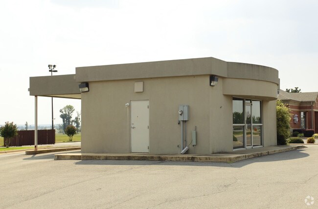


Property Detail
1040 Main St
780-00262-000
PT SE NW
Financialbuilding
Faulkner
B and X Area of moderate flood hazard, usually the area between the limits of the 100-year and 500-year floods.
Arkansas
2025
1.50 AC
2025
Faulkner County
030302
Little Rock/N Little Rock
1,200 SF
Little Rock-North Little Rock-Conway, AR
NEARBY LISTINGS FOR SALE OR LEASE
DEMOGRAPHICS near 1040 Main St
1 mile
3 mile
5 mile
2025 Total Population
1,732
6,893
11,989
2030 Population
1,827
7,305
12,748
Pop Growth 2025-2030
+ 5.48%
+ 5.98%
+ 6.33%
Average Age
36
37
38
2025 Total Households
577
2,384
4,235
HH Growth 2025-2030
+ 5.72%
+ 6.29%
+ 6.59%
Median Household Inc
$83,896
$81,557
$80,951
Avg Household Size
2.80
2.80
2.80
2025 Avg HH Vehicles
2.00
2.00
2.00
Median Home Value
$202,518
$232,379
$241,481
Median Year Built
2002
2000
1999
Nearby Places
Map Layers
Map Styles
 Street
 Aerial
Layers
 Traffic
 Biking
Places
Listings with unknown addresses are not visible on the map
- Restaurants
- Banks
- Shops
- Fitness
- Groceries
PUBLIC TRANSPORTATION
AIRPORT
Bill and Hillary Clinton Ntl/Adams Field
Drive
Walk
Distance
Bill and Hillary Clinton Ntl/Adams Field
56 min
39.2 mi
Nearby Properties
Address
Land Use
TOTAL SIZE
Lot Size
Zoning
Address
Land Use
TOTAL SIZE
Lot Size
Zoning
33,210 SF
1.52 AC
Address
Land Use
TOTAL SIZE
Lot Size
Zoning
44,258 SF
19.97 AC
Address
Land Use
TOTAL SIZE
Lot Size
Zoning
3,440 SF
1.11 AC
Address
Land Use
TOTAL SIZE
Lot Size
Zoning
16,644 SF
1.76 AC
Address
Land Use
TOTAL SIZE
Lot Size
Zoning
5,608 SF
1.15 AC
Address
Land Use
TOTAL SIZE
Lot Size
Zoning
4,050 SF
3.75 AC
Address
Land Use
TOTAL SIZE
Lot Size
Zoning
15,328 SF
32.22 AC
Address
Land Use
TOTAL SIZE
Lot Size
Zoning
16,500 SF
7.15 AC
Address
Land Use
TOTAL SIZE
Lot Size
Zoning
25,400 SF
3.30 AC
Address
Land Use
TOTAL SIZE
Lot Size
Zoning
12,001 SF
1.74 AC
Address
Land Use
TOTAL SIZE
Lot Size
Zoning
10,829 SF
1.83 AC
Address
Land Use
TOTAL SIZE
Lot Size
Zoning
7,003 SF
1.92 AC
Address
Land Use
TOTAL SIZE
Lot Size
Zoning
11,040 SF
1.07 AC
Address
Land Use
TOTAL SIZE
Lot Size
Zoning
29,440 SF
3.42 AC
Address
Land Use
TOTAL SIZE
Lot Size
Zoning
12,480 SF
1.32 AC
Address
Land Use
TOTAL SIZE
Lot Size
Zoning
7,130 SF
0.71 AC
Address
Land Use
TOTAL SIZE
Lot Size
Zoning
4,002 SF
4.24 AC
Address
Land Use
TOTAL SIZE
Lot Size
Zoning
7,620 SF
1.52 AC
Address
Land Use
TOTAL SIZE
Lot Size
Zoning
21,783 SF
4.01 AC
Address
Land Use
TOTAL SIZE
Lot Size
Zoning
4,340 SF
1 AC
Address
Land Use
TOTAL SIZE
Lot Size
Zoning
8,583 SF
2 AC
Address
Land Use
TOTAL SIZE
Lot Size
Zoning
13,513 SF
2 AC
Address
Land Use
TOTAL SIZE
Lot Size
Zoning
4,706 SF
1.43 AC
Address
Land Use
TOTAL SIZE
Lot Size
Zoning
2,416 SF
0.72 AC
Address
Land Use
TOTAL SIZE
Lot Size
Zoning
7,000 SF
2.26 AC
Address
Land Use
TOTAL SIZE
Lot Size
Zoning
8,680 SF
2.19 AC
Address
Land Use
TOTAL SIZE
Lot Size
Zoning
4,728 SF
0.54 AC
Address
Land Use
TOTAL SIZE
Lot Size
Zoning
9,871 SF
1.55 AC
Address
Land Use
TOTAL SIZE
Lot Size
Zoning
3,760 SF
7.93 AC
The World's #1 Commercial Real Estate Marketplace
Connect with us
© 2026 CoStar Group
The information above has been obtained from sources believed reliable. While we do not doubt its accuracy we have not verified it and make no guarantee, warranty or representation about it. It is your responsibility to independently confirm its accuracy and completeness. Any projections, opinions, assumptions, or estimates used are for example only and do not represent the current or future performance of the property. The value of this transaction to you depends on tax and other factors which should be evaluated by your tax, financial, and legal advisors. You and your advisors should conduct a careful, independent investigation of the property to determine to your satisfaction the suitability of the property for your needs.