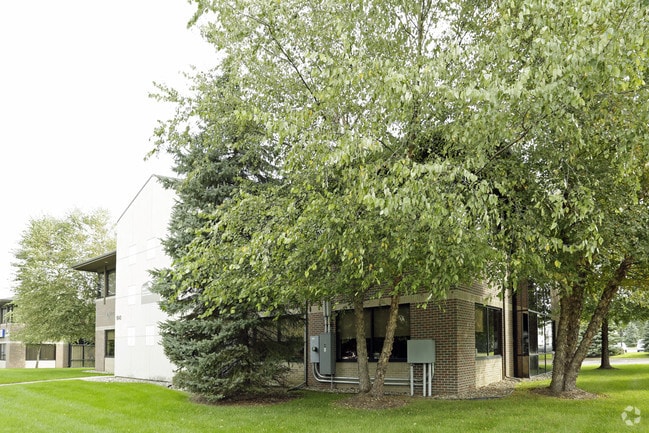
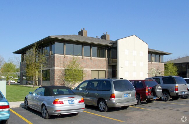
Property Record
1040 N 10Th St, Kalamazoo, MI 49009
Current Lease Availabilities
NEARBY LISTINGS FOR SALE OR LEASE
Property Detail
1040 N 10Th St
05-13-160-008
Westpointe Office Park Condos
Commercialnec
WESTPOINTE OFFICE PARK UNIT 7B* **11-01 2001 SPLIT FROM 13-155-013
X
Kalamazoo
26077C0175E
Michigan
2024
0.03 AC
2025
Western Kalamazoo County
002908
West Michigan
10,176 SF
Kalamazoo-Portage, MI
DEMOGRAPHICS near 1040 N 10Th St
1 Mile
3 Mile
5 Mile
2024 Total Population
5,020
49,108
99,385
2029 Population
5,028
49,204
99,556
Pop Growth 2024-2029
+ 0.16%
+ 0.20%
+ 0.17%
Average Age
39
35
36
2024 Total Households
2,183
20,879
41,606
HH Growth 2024-2029
0.00%
+ 0.22%
+ 0.19%
Median Household Inc
$65,669
$44,755
$50,547
Avg Household Size
2.20
2.10
2.20
2024 Avg HH Vehicles
2.00
2.00
2.00
Median Home Value
$264,178
$210,753
$211,607
Median Year Built
1983
1983
1975
Nearby Places
- Restaurants
- Banks
- Shops
- Fitness
- Groceries
PUBLIC TRANSPORTATION
COMMUTER RAIL
Kalamazoo (Blue Water - Amtrak, Wolverine - Amtrak)
DRIVE
WALK
Distance
Kalamazoo (Blue Water - Amtrak, Wolverine - Amtrak)
10 min
4.8 mi
AIRPORT
Kalamazoo/Battle Creek International
DRIVE
WALK
Distance
Kalamazoo/Battle Creek International
19 min
10.5 mi
Freight Ports
Port of Toledo
DRIVE
WALK
Distance
Port of Toledo
183 min
152.0 mi
Nearby Properties
Address
Land Use
TOTAL SIZE
Lot Size
Zoning
Address
Land Use
TOTAL SIZE
Lot Size
Zoning
374,906 SF
16.31 AC
RM-36
Address
Land Use
TOTAL SIZE
Lot Size
Zoning
289,865 SF
23.60 AC
PUD
Address
Land Use
TOTAL SIZE
Lot Size
Zoning
125,343 SF
37.39 AC
C-1 COM
Address
Land Use
TOTAL SIZE
Lot Size
Zoning
265,402 SF
21.70 AC
R-4 MUL
Address
Land Use
TOTAL SIZE
Lot Size
Zoning
35,870 SF
12.78 AC
CC
Address
Land Use
TOTAL SIZE
Lot Size
Zoning
449,275 SF
33.70 AC
R-4 MUL
Address
Land Use
TOTAL SIZE
Lot Size
Zoning
331,571 SF
19.68 AC
RM-15
Address
Land Use
TOTAL SIZE
Lot Size
Zoning
304,247 SF
44.91 AC
R-4 MUL
Address
Land Use
TOTAL SIZE
Lot Size
Zoning
329,276 SF
43.86 AC
RM-1
Address
Land Use
TOTAL SIZE
Lot Size
Zoning
228,088 SF
19.14 AC
R-4 MUL
Address
Land Use
TOTAL SIZE
Lot Size
Zoning
315,422 SF
25.40 AC
RM-15
Address
Land Use
TOTAL SIZE
Lot Size
Zoning
14,095 SF
27.05 AC
PUD
Address
Land Use
TOTAL SIZE
Lot Size
Zoning
186,073 SF
28.64 AC
C COMM
Address
Land Use
TOTAL SIZE
Lot Size
Zoning
447,142 SF
34.79 AC
R-4 MUL
Address
Land Use
TOTAL SIZE
Lot Size
Zoning
126.09 AC
R-5 MHP
Address
Land Use
TOTAL SIZE
Lot Size
Zoning
291,495 SF
18.39 AC
PUD
Address
Land Use
TOTAL SIZE
Lot Size
Zoning
105,046 SF
19.30 AC
RM-15
Address
Land Use
TOTAL SIZE
Lot Size
Zoning
273,122 SF
16.12 AC
PUD
Address
Land Use
TOTAL SIZE
Lot Size
Zoning
201,940 SF
9.30 AC
RM-36
Address
Land Use
TOTAL SIZE
Lot Size
Zoning
230,820 SF
16.50 AC
R-4 MUL
Address
Land Use
TOTAL SIZE
Lot Size
Zoning
273,205 SF
24.70 AC
R-4 MUL
Address
Land Use
TOTAL SIZE
Lot Size
Zoning
217,443 SF
36.48 AC
C COMM
Address
Land Use
TOTAL SIZE
Lot Size
Zoning
128,586 SF
14.27 AC
R-4 MUL
Address
Land Use
TOTAL SIZE
Lot Size
Zoning
186,652 SF
28.29 AC
PUD
Address
Land Use
TOTAL SIZE
Lot Size
Zoning
235,227 SF
25.18 AC
R-4 MUL
Address
Land Use
TOTAL SIZE
Lot Size
Zoning
224,424 SF
18.89 AC
R-4 MUL
Address
Land Use
TOTAL SIZE
Lot Size
Zoning
216,972 SF
30.83 AC
C COMM
Address
Land Use
TOTAL SIZE
Lot Size
Zoning
179,628 SF
12.99 AC
RM-15
Address
Land Use
TOTAL SIZE
Lot Size
Zoning
86,306 SF
3.72 AC
C COMM
Address
Land Use
TOTAL SIZE
Lot Size
Zoning
136,001 SF
22.56 AC
C COMM
The World's #1 Commercial Real Estate Marketplace
Connect with us
© 2025 CoStar Group
The information above has been obtained from sources believed reliable. While we do not doubt its accuracy we have not verified it and make no guarantee, warranty or representation about it. It is your responsibility to independently confirm its accuracy and completeness. Any projections, opinions, assumptions, or estimates used are for example only and do not represent the current or future performance of the property. The value of this transaction to you depends on tax and other factors which should be evaluated by your tax, financial, and legal advisors. You and your advisors should conduct a careful, independent investigation of the property to determine to your satisfaction the suitability of the property for your needs.