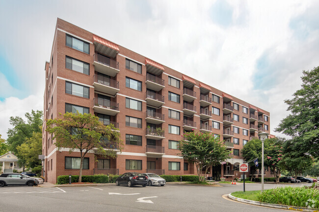
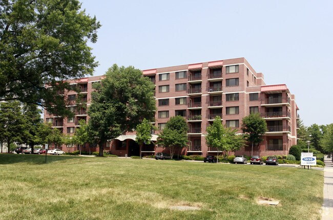
Property Record
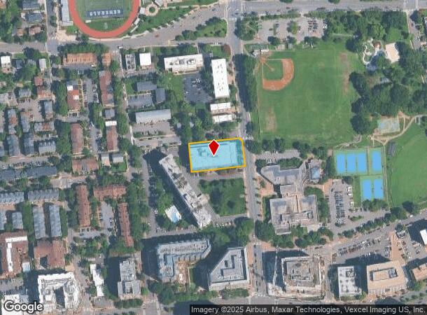
1040 N Quincy St, Arlington, VA 22201
NEARBY LISTINGS FOR SALE OR LEASE
Property Detail
1040 N Quincy St
Washington-Arlington-Alexandria, DC-VA-MD-WV
Library Courts
14-029-016
LOT 1040 LIBRARY COURTS 28,996 SQ FT
Apartment
Arlington
X
Virginia
51013C0038D
1040
2025
0.67 AC
2025
Ballston/Virginia Square
101407
Washington, DC
910,000 SF
DEMOGRAPHICS near 1040 N Quincy St
1 Mile
3 Mile
5 Mile
2024 Total Population
46,603
247,358
621,670
2029 Population
46,011
243,071
597,822
Pop Growth 2024-2029
(1.27%)
(1.73%)
(3.84%)
Average Age
37
38
38
2024 Total Households
22,812
107,880
285,470
HH Growth 2024-2029
(1.36%)
(1.80%)
(4.59%)
Median Household Inc
$140,014
$120,639
$120,273
Avg Household Size
2.00
2.20
2.10
2024 Avg HH Vehicles
1.00
1.00
1.00
Median Home Value
$800,153
$779,317
$785,001
Median Year Built
1991
1973
1967
Nearby Places
Map Layers
Map Styles
 Street
 Aerial
- Restaurants
- Banks
- Shops
- Fitness
- Groceries
PUBLIC TRANSPORTATION
TRANSIT/SUBWAY
Ballston-Mu (Orange Line - Washington Metropolitan Area Transit Authority Metrorail (Metrorail), Silver Line - Washington Metropolitan Area Transit Authority Metrorail (Metrorail))
DRIVE
WALK
Distance
Ballston-Mu (Orange Line - Washington Metropolitan Area Transit Authority Metrorail (Metrorail), Silver Line - Washington Metropolitan Area Transit Authority Metrorail (Metrorail))
1 min
6 min
0.3 mi
Virginia Square-Gmu (Orange Line - Washington Metropolitan Area Transit Authority Metrorail (Metrorail), Silver Line - Washington Metropolitan Area Transit Authority Metrorail (Metrorail))
DRIVE
WALK
Distance
Virginia Square-Gmu (Orange Line - Washington Metropolitan Area Transit Authority Metrorail (Metrorail), Silver Line - Washington Metropolitan Area Transit Authority Metrorail (Metrorail))
1 min
7 min
0.4 mi
Clarendon (Orange Line - Washington Metropolitan Area Transit Authority Metrorail (Metrorail), Silver Line - Washington Metropolitan Area Transit Authority Metrorail (Metrorail))
DRIVE
WALK
Distance
Clarendon (Orange Line - Washington Metropolitan Area Transit Authority Metrorail (Metrorail), Silver Line - Washington Metropolitan Area Transit Authority Metrorail (Metrorail))
2 min
16 min
0.8 mi
COMMUTER RAIL
Crystal City (Fredericksburg Line - Virginia Railway Express, Manassas Line - Virginia Railway Express)
DRIVE
WALK
Distance
Crystal City (Fredericksburg Line - Virginia Railway Express, Manassas Line - Virginia Railway Express)
10 min
4.5 mi
4 (Fredericksburg Line - Virginia Railway Express, Manassas Line - Virginia Railway Express)
DRIVE
WALK
Distance
4 (Fredericksburg Line - Virginia Railway Express, Manassas Line - Virginia Railway Express)
12 min
5.6 mi
AIRPORT
Ronald Reagan Washington Ntl
DRIVE
WALK
Distance
Ronald Reagan Washington Ntl
14 min
5.8 mi
Washington Dulles International
DRIVE
WALK
Distance
Washington Dulles International
36 min
22.3 mi
Freight Ports
Port of Baltimore
DRIVE
WALK
Distance
Port of Baltimore
66 min
44.5 mi
Nearby Properties
Address
Land Use
TOTAL SIZE
Lot Size
Zoning
Address
Land Use
TOTAL SIZE
Lot Size
Zoning
6,500,000 SF
92.03 AC
S-3A
Address
Land Use
TOTAL SIZE
Lot Size
Zoning
2,455,000 SF
11.08 AC
MU-2
Address
Land Use
TOTAL SIZE
Lot Size
Zoning
900,000 SF
260 AC
S-3A
Address
Land Use
TOTAL SIZE
Lot Size
Zoning
77.26 AC
R-3/GT
Address
Land Use
TOTAL SIZE
Lot Size
Zoning
636,768 SF
1.91 AC
C-O-ROSSLY
Address
Land Use
TOTAL SIZE
Lot Size
Zoning
508,547 SF
4.58 AC
C-O-2.5
Address
Land Use
TOTAL SIZE
Lot Size
Zoning
293,674 SF
13.45 AC
C-O-2.5
Address
Land Use
TOTAL SIZE
Lot Size
Zoning
20.19 AC
S-3A/S-D
Address
Land Use
TOTAL SIZE
Lot Size
Zoning
45,523 SF
0.24 AC
C-O-ROSSLY
Address
Land Use
TOTAL SIZE
Lot Size
Zoning
62,298 SF
2.58 AC
R-5
Address
Land Use
TOTAL SIZE
Lot Size
Zoning
1,882 SF
0.97 AC
C-O-A
Address
Land Use
TOTAL SIZE
Lot Size
Zoning
4.67 AC
MU-13;MU-1
Address
Land Use
TOTAL SIZE
Lot Size
Zoning
580,759 SF
0.69 AC
C-O/C-O-RO
Address
Land Use
TOTAL SIZE
Lot Size
Zoning
633,810 SF
3.45 AC
RA-H-3.2
Address
Land Use
TOTAL SIZE
Lot Size
Zoning
591,243 SF
1.90 AC
RA-H-3.2
Address
Land Use
TOTAL SIZE
Lot Size
Zoning
986,000 SF
2.30 AC
C-O-A
Address
Land Use
TOTAL SIZE
Lot Size
Zoning
597,364 SF
1.66 AC
C-O/C-O-2.
Address
Land Use
TOTAL SIZE
Lot Size
Zoning
224,700 SF
1.30 AC
C-O-2.5
Address
Land Use
TOTAL SIZE
Lot Size
Zoning
12,786 SF
2.19 AC
C-2
Address
Land Use
TOTAL SIZE
Lot Size
Zoning
354,000 SF
0.67 AC
C-O-ROSSLY
Address
Land Use
TOTAL SIZE
Lot Size
Zoning
924,015 SF
89.81 AC
S-3A
Address
Land Use
TOTAL SIZE
Lot Size
Zoning
523,155 SF
1.76 AC
RA-H-3.2
Address
Land Use
TOTAL SIZE
Lot Size
Zoning
0.94 AC
C-O-2.5
Address
Land Use
TOTAL SIZE
Lot Size
Zoning
436 SF
75 AC
UNZONED
Address
Land Use
TOTAL SIZE
Lot Size
Zoning
9,800 SF
1.40 AC
C-O-A
Address
Land Use
TOTAL SIZE
Lot Size
Zoning
727,145 SF
19.72 AC
S-3A
Address
Land Use
TOTAL SIZE
Lot Size
Zoning
528 SF
296.59 AC
MU-11;MU-1
The World's #1 Commercial Real Estate Marketplace
Connect with us
© 2025 CoStar Group
The information above has been obtained from sources believed reliable. While we do not doubt its accuracy we have not verified it and make no guarantee, warranty or representation about it. It is your responsibility to independently confirm its accuracy and completeness. Any projections, opinions, assumptions, or estimates used are for example only and do not represent the current or future performance of the property. The value of this transaction to you depends on tax and other factors which should be evaluated by your tax, financial, and legal advisors. You and your advisors should conduct a careful, independent investigation of the property to determine to your satisfaction the suitability of the property for your needs.