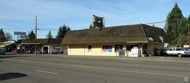
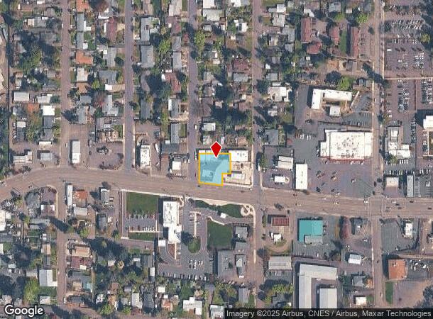
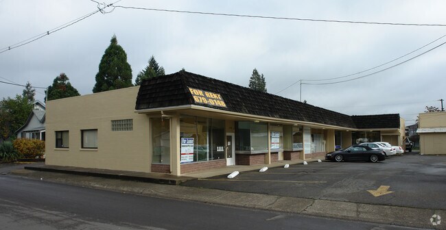
Property Record
1040 W Harvard Ave, Roseburg, OR 97471
Property Detail
1040 W Harvard Ave
Roseburg, OR
Maynards Harvard Ave Add
R29725
MAYNARDS HARVARD AVE ADD, LOT PT 1, 2, 3 (M&B INST 2022-10446 ADJ UNIT 1), ACRES 0.31
Commercialnec
Douglas
X
Oregon
41019C1728F
1,2,3
2025
0.31 AC
2025
Oregon West Area
140000
Other Market Areas
3,629 SF
NEARBY LISTINGS FOR SALE OR LEASE
DEMOGRAPHICS near 1040 W Harvard Ave
1 mile
3 mile
5 mile
2024 Total Population
6,306
31,572
44,393
2029 Population
6,576
33,014
46,204
Pop Growth 2024-2029
+ 4.28%
+ 4.57%
+ 4.08%
Average Age
42
43
43
2024 Total Households
2,658
13,342
18,424
HH Growth 2024-2029
+ 4.44%
+ 4.65%
+ 4.14%
Median Household Inc
$45,165
$46,723
$49,924
Avg Household Size
2.20
2.20
2.30
2024 Avg HH Vehicles
2.00
2.00
2.00
Median Home Value
$244,719
$263,264
$261,217
Median Year Built
1959
1976
1979
Nearby Places
Map Layers
Map Styles
 Street
 Aerial
Transit
 Traffic
 Biking
Places
Listings with unknown addresses are not visible on the map
- Restaurants
- Banks
- Shops
- Fitness
- Groceries
SALE & LEASE HISTORY
LISTING DATE
SALE/LEASE

Feb 04, 2020
For Lease
Nearby Properties
Address
Land Use
TOTAL SIZE
Lot Size
Zoning
Address
Land Use
TOTAL SIZE
Lot Size
Zoning
276,720 SF
18.77 AC
PR
Address
Land Use
TOTAL SIZE
Lot Size
Zoning
149.62 AC
PR
Address
Land Use
TOTAL SIZE
Lot Size
Zoning
1,000 SF
18.99 AC
PR
Address
Land Use
TOTAL SIZE
Lot Size
Zoning
239,143 SF
6.29 AC
PR
Address
Land Use
TOTAL SIZE
Lot Size
Zoning
102.28 AC
AP
Address
Land Use
TOTAL SIZE
Lot Size
Zoning
9.96 AC
PR
Address
Land Use
TOTAL SIZE
Lot Size
Zoning
63.52 AC
PR
Address
Land Use
TOTAL SIZE
Lot Size
Zoning
199,245 SF
13.97 AC
C3
Address
Land Use
TOTAL SIZE
Lot Size
Zoning
86,285 SF
4.91 AC
C3
Address
Land Use
TOTAL SIZE
Lot Size
Zoning
152,625 SF
20.21 AC
C3
Address
Land Use
TOTAL SIZE
Lot Size
Zoning
90,785 SF
2.76 AC
PR
Address
Land Use
TOTAL SIZE
Lot Size
Zoning
230,093 SF
17.80 AC
C3
Address
Land Use
TOTAL SIZE
Lot Size
Zoning
82,532 SF
2.43 AC
C3
Address
Land Use
TOTAL SIZE
Lot Size
Zoning
40 AC
M3
Address
Land Use
TOTAL SIZE
Lot Size
Zoning
115,574 SF
4.32 AC
C3
Address
Land Use
TOTAL SIZE
Lot Size
Zoning
43,384 SF
9.16 AC
PR
Address
Land Use
TOTAL SIZE
Lot Size
Zoning
124,320 SF
13.02 AC
MR40
Address
Land Use
TOTAL SIZE
Lot Size
Zoning
103,469 SF
10.45 AC
MU
Address
Land Use
TOTAL SIZE
Lot Size
Zoning
2.11 AC
MU
Address
Land Use
TOTAL SIZE
Lot Size
Zoning
115,934 SF
3.48 AC
MR29
Address
Land Use
TOTAL SIZE
Lot Size
Zoning
119,646 SF
10.03 AC
MR18
Address
Land Use
TOTAL SIZE
Lot Size
Zoning
42,708 SF
0.78 AC
PR
Address
Land Use
TOTAL SIZE
Lot Size
Zoning
13.73 AC
M2
Address
Land Use
TOTAL SIZE
Lot Size
Zoning
68,135 SF
8.13 AC
C3
Address
Land Use
TOTAL SIZE
Lot Size
Zoning
4.76 AC
PR
Address
Land Use
TOTAL SIZE
Lot Size
Zoning
37,755 SF
2.80 AC
C3
Address
Land Use
TOTAL SIZE
Lot Size
Zoning
2.55 AC
M2
Address
Land Use
TOTAL SIZE
Lot Size
Zoning
129,644 SF
4.85 AC
MU
Address
Land Use
TOTAL SIZE
Lot Size
Zoning
41,353 SF
4.18 AC
C3
Address
Land Use
TOTAL SIZE
Lot Size
Zoning
57,685 SF
5.34 AC
C3
The World's #1 Commercial Real Estate Marketplace
Connect with us
© 2026 CoStar Group
The information above has been obtained from sources believed reliable. While we do not doubt its accuracy we have not verified it and make no guarantee, warranty or representation about it. It is your responsibility to independently confirm its accuracy and completeness. Any projections, opinions, assumptions, or estimates used are for example only and do not represent the current or future performance of the property. The value of this transaction to you depends on tax and other factors which should be evaluated by your tax, financial, and legal advisors. You and your advisors should conduct a careful, independent investigation of the property to determine to your satisfaction the suitability of the property for your needs.