Property Record
10400 S Crater Rd, South Prince George, VA 23805
NEARBY LISTINGS FOR SALE OR LEASE
-
-
View all South Prince George listings for sale on LoopNet.com
Property Detail
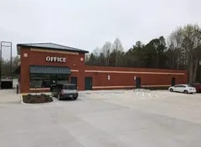
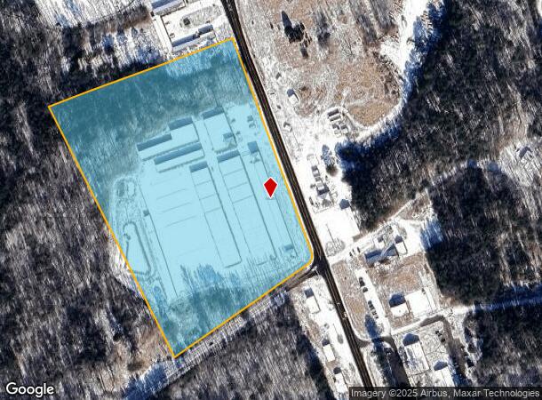
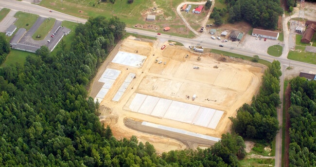
10400 S Crater Rd
Richmond, VA
SECOND SWAMP; AC:13.249;
330(0A)00-003-A
Prince George
Publicstorage
Virginia
0
3a
2025
13.24 AC
850501
Prince George
960 SF
Richmond VA
DEMOGRAPHICS near 10400 S Crater Rd
1 Mile
3 Mile
5 Mile
2024 Total Population
1,042
12,461
40,144
2029 Population
1,014
12,160
40,028
Pop Growth 2024-2029
(2.69%)
(2.42%)
(0.29%)
Average Age
40
43
39
2024 Total Households
490
5,395
16,839
HH Growth 2024-2029
(2.65%)
(2.63%)
(0.49%)
Median Household Inc
$63,600
$65,072
$52,234
Avg Household Size
2.10
2.20
2.30
2024 Avg HH Vehicles
2.00
2.00
2.00
Median Home Value
$215,217
$171,557
$163,634
Median Year Built
1986
1977
1974
Nearby Places
- Restaurants
- Banks
- Shops
- Fitness
- Groceries
PUBLIC TRANSPORTATION
COMMUTER RAIL
Petersburg Amtrak Station (Carolinian - Amtrak, Northeast Regional - Amtrak, Palmetto - Amtrak, Silver Meteor - Amtrak, Silver Star - Amtrak)
DRIVE
WALK
Distance
Petersburg Amtrak Station (Carolinian - Amtrak, Northeast Regional - Amtrak, Palmetto - Amtrak, Silver Meteor - Amtrak, Silver Star - Amtrak)
12 min
7.5 mi
AIRPORT
Richmond International
DRIVE
WALK
Distance
Richmond International
42 min
33.0 mi
Freight Ports
Virginia Port Authority - Richmond
DRIVE
WALK
Distance
Virginia Port Authority - Richmond
34 min
23.7 mi
Nearby Properties
Address
Land Use
TOTAL SIZE
Lot Size
Zoning
Address
Land Use
TOTAL SIZE
Lot Size
Zoning
24.02 AC
B-2C
Address
Land Use
TOTAL SIZE
Lot Size
Zoning
67,456 SF
512.10 AC
A2
Address
Land Use
TOTAL SIZE
Lot Size
Zoning
28.17 AC
PUD
Address
Land Use
TOTAL SIZE
Lot Size
Zoning
220.52 AC
R1
Address
Land Use
TOTAL SIZE
Lot Size
Zoning
17.09 AC
PUD
Address
Land Use
TOTAL SIZE
Lot Size
Zoning
264,335 SF
70 AC
M-2
Address
Land Use
TOTAL SIZE
Lot Size
Zoning
11.57 AC
PUD
Address
Land Use
TOTAL SIZE
Lot Size
Zoning
205,626 SF
151.04 AC
M-2
Address
Land Use
TOTAL SIZE
Lot Size
Zoning
407,650 SF
136.67 AC
M-2
Address
Land Use
TOTAL SIZE
Lot Size
Zoning
65,214 SF
8.46 AC
R-4
Address
Land Use
TOTAL SIZE
Lot Size
Zoning
42,561 SF
6.91 AC
B-2C
Address
Land Use
TOTAL SIZE
Lot Size
Zoning
151,980 SF
23.12 AC
PUD
Address
Land Use
TOTAL SIZE
Lot Size
Zoning
149,472 SF
14.68 AC
R-4
Address
Land Use
TOTAL SIZE
Lot Size
Zoning
8.72 AC
PUD
Address
Land Use
TOTAL SIZE
Lot Size
Zoning
1.09 AC
PUD
Address
Land Use
TOTAL SIZE
Lot Size
Zoning
102,424 SF
14.71 AC
PUD
Address
Land Use
TOTAL SIZE
Lot Size
Zoning
84,064 SF
15.54 AC
PUD
Address
Land Use
TOTAL SIZE
Lot Size
Zoning
33,360 SF
0.45 AC
B-2C
Address
Land Use
TOTAL SIZE
Lot Size
Zoning
68,713 SF
2.33 AC
11
Address
Land Use
TOTAL SIZE
Lot Size
Zoning
58,986 SF
3.83 AC
11
Address
Land Use
TOTAL SIZE
Lot Size
Zoning
44,311 SF
9.05 AC
R-1
Address
Land Use
TOTAL SIZE
Lot Size
Zoning
8 AC
PUD
Address
Land Use
TOTAL SIZE
Lot Size
Zoning
16 AC
R-A
Address
Land Use
TOTAL SIZE
Lot Size
Zoning
136,293 SF
23.70 AC
PUD
Address
Land Use
TOTAL SIZE
Lot Size
Zoning
40,884 SF
2.50 AC
Address
Land Use
TOTAL SIZE
Lot Size
Zoning
76,005 SF
16.13 AC
PUD
Address
Land Use
TOTAL SIZE
Lot Size
Zoning
85,838 SF
10.18 AC
B-2C
Address
Land Use
TOTAL SIZE
Lot Size
Zoning
39,886 SF
2.74 AC
11
Address
Land Use
TOTAL SIZE
Lot Size
Zoning
70,320 SF
5.83 AC
B-2C
The World's #1 Commercial Real Estate Marketplace
Connect with us
© 2025 CoStar Group
The information above has been obtained from sources believed reliable. While we do not doubt its accuracy we have not verified it and make no guarantee, warranty or representation about it. It is your responsibility to independently confirm its accuracy and completeness. Any projections, opinions, assumptions, or estimates used are for example only and do not represent the current or future performance of the property. The value of this transaction to you depends on tax and other factors which should be evaluated by your tax, financial, and legal advisors. You and your advisors should conduct a careful, independent investigation of the property to determine to your satisfaction the suitability of the property for your needs.