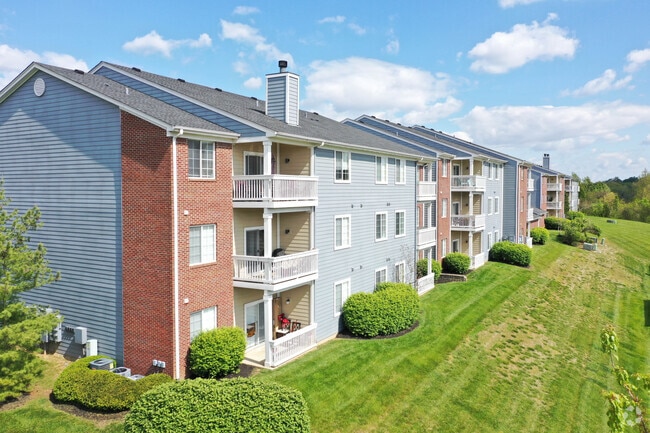
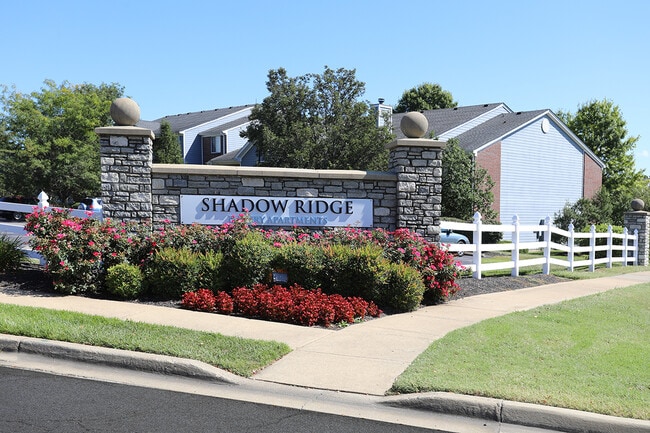
Property Record
10400 Shadow Ridge Ln, Louisville, KY 40241

NEARBY LISTINGS FOR SALE OR LEASE
-
-
View all Louisville listings for sale on LoopNet.com
Property Detail
10400 Shadow Ridge Ln
000801450000
Ns Ky 22 Shadow Ridge Apts
Apartment
25.6524 AC +/- NS KY 22 SHADOW RIDGE APTS
AE
Jefferson
21185C0185D
Kentucky
2025
25.65 AC
2025
Outer East End
010323
Louisville
4,283 SF
Louisville/Jefferson County, KY-IN
DEMOGRAPHICS near 10400 Shadow Ridge Ln
1 Mile
3 Mile
5 Mile
2024 Total Population
11,019
48,462
115,252
2029 Population
11,069
48,441
115,547
Pop Growth 2024-2029
+ 0.45%
(0.04%)
+ 0.26%
Average Age
41
41
42
2024 Total Households
4,719
19,506
46,750
HH Growth 2024-2029
+ 0.32%
(0.28%)
+ 0.01%
Median Household Inc
$96,512
$98,663
$98,466
Avg Household Size
2.30
2.50
2.40
2024 Avg HH Vehicles
2.00
2.00
2.00
Median Home Value
$327,110
$323,348
$344,116
Median Year Built
2002
1994
1990
Nearby Places
Map Layers
Map Styles
 Street
 Aerial
- Restaurants
- Banks
- Shops
- Fitness
- Groceries
PUBLIC TRANSPORTATION
AIRPORT
Louisville Muhammad Ali International
DRIVE
WALK
Distance
Louisville Muhammad Ali International
32 min
19.7 mi
Freight Ports
Port of Toledo
DRIVE
WALK
Distance
Port of Toledo
341 min
294.9 mi
Nearby Properties
Address
Land Use
TOTAL SIZE
Lot Size
Zoning
Address
Land Use
TOTAL SIZE
Lot Size
Zoning
39,200 SF
38.66 AC
C2-COMMERC
Address
Land Use
TOTAL SIZE
Lot Size
Zoning
Address
Land Use
TOTAL SIZE
Lot Size
Zoning
2,922 SF
23.24 AC
R4-RESIDEN
Address
Land Use
TOTAL SIZE
Lot Size
Zoning
160,000 SF
421.24 AC
PEC-PLANNE
Address
Land Use
TOTAL SIZE
Lot Size
Zoning
17.93 AC
R4-RESIDEN
Address
Land Use
TOTAL SIZE
Lot Size
Zoning
11.92 AC
OTF-OFFICE
Address
Land Use
TOTAL SIZE
Lot Size
Zoning
10.31 AC
Address
Land Use
TOTAL SIZE
Lot Size
Zoning
1,582 SF
4.25 AC
R4-RESIDEN
Address
Land Use
TOTAL SIZE
Lot Size
Zoning
2,325 SF
17.65 AC
R7-RESIDEN
Address
Land Use
TOTAL SIZE
Lot Size
Zoning
Address
Land Use
TOTAL SIZE
Lot Size
Zoning
21,340 SF
17.43 AC
R7-RESIDEN
Address
Land Use
TOTAL SIZE
Lot Size
Zoning
11,484 SF
13.83 AC
R7-RESIDEN
Address
Land Use
TOTAL SIZE
Lot Size
Zoning
6.90 AC
C2-COMMERC
Address
Land Use
TOTAL SIZE
Lot Size
Zoning
23,284 SF
19.61 AC
R5A-RESIDE
Address
Land Use
TOTAL SIZE
Lot Size
Zoning
62,500 SF
59.16 AC
PEC-PLANNE
Address
Land Use
TOTAL SIZE
Lot Size
Zoning
17,352 SF
10.86 AC
R7-RESIDEN
Address
Land Use
TOTAL SIZE
Lot Size
Zoning
112,959 SF
6.94 AC
Address
Land Use
TOTAL SIZE
Lot Size
Zoning
62,840 SF
29.42 AC
PEC-PLANNE
Address
Land Use
TOTAL SIZE
Lot Size
Zoning
124,760 SF
8.33 AC
OR3-OFFICE
Address
Land Use
TOTAL SIZE
Lot Size
Zoning
59,386 SF
10.56 AC
OR3-OFFICE
Address
Land Use
TOTAL SIZE
Lot Size
Zoning
116,445 SF
12.21 AC
C1-COMMERC
Address
Land Use
TOTAL SIZE
Lot Size
Zoning
1,416 SF
11.98 AC
R7-RESIDEN
Address
Land Use
TOTAL SIZE
Lot Size
Zoning
90,433 SF
9.14 AC
OR3-OFFICE
Address
Land Use
TOTAL SIZE
Lot Size
Zoning
8,920 SF
11.43 AC
R6-RESIDEN
Address
Land Use
TOTAL SIZE
Lot Size
Zoning
154,911 SF
15.97 AC
C2-COMMERC
Address
Land Use
TOTAL SIZE
Lot Size
Zoning
9,032 SF
8.12 AC
R7-RESIDEN
Address
Land Use
TOTAL SIZE
Lot Size
Zoning
4.05 AC
R1-RESIDEN
Address
Land Use
TOTAL SIZE
Lot Size
Zoning
3,359 SF
15.07 AC
R4-RESIDEN
Address
Land Use
TOTAL SIZE
Lot Size
Zoning
16,672 SF
6.51 AC
R6-RESIDEN
The World's #1 Commercial Real Estate Marketplace
Connect with us
© 2026 CoStar Group
The information above has been obtained from sources believed reliable. While we do not doubt its accuracy we have not verified it and make no guarantee, warranty or representation about it. It is your responsibility to independently confirm its accuracy and completeness. Any projections, opinions, assumptions, or estimates used are for example only and do not represent the current or future performance of the property. The value of this transaction to you depends on tax and other factors which should be evaluated by your tax, financial, and legal advisors. You and your advisors should conduct a careful, independent investigation of the property to determine to your satisfaction the suitability of the property for your needs.