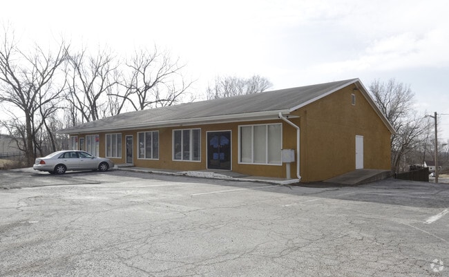
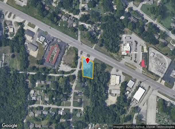
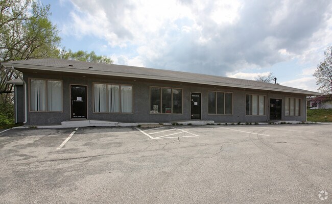
Property Record
10401 E Us Highway 40 Hwy, Independence, MO 64055
NEARBY LISTINGS FOR SALE OR LEASE
Property Detail
10401 E Us Highway 40 Hwy
32-120-16-05-00-0-00-000
W B Dickinsons Addition
Miscellaneous
SEC-21 TWP-49 RNG-32 BEG SE COR OF INTERSEC OF HARDY & 40 HW Y TH SE 190 TH S 151.67 TH WLY 115.61 TH N TO POB
X
Jackson
29095C0287G
Missouri
2024
0.49 AC
2025
East Jackson County
012501
Kansas City
4,528 SF
Kansas City, MO-KS
DEMOGRAPHICS near 10401 E Us Highway 40 Hwy
1 Mile
3 Mile
5 Mile
2024 Total Population
8,450
65,720
174,763
2029 Population
8,373
65,317
174,871
Pop Growth 2024-2029
(0.91%)
(0.61%)
+ 0.06%
Average Age
40
40
40
2024 Total Households
3,637
27,155
71,669
HH Growth 2024-2029
(1.10%)
(0.75%)
(0.16%)
Median Household Inc
$47,038
$56,179
$51,515
Avg Household Size
2.30
2.30
2.30
2024 Avg HH Vehicles
2.00
2.00
2.00
Median Home Value
$145,538
$140,176
$137,000
Median Year Built
1964
1961
1962
Nearby Places
Map Layers
Map Styles
 Street
 Aerial
- Restaurants
- Banks
- Shops
- Fitness
- Groceries
PUBLIC TRANSPORTATION
COMMUTER RAIL
Independence Amtrak Station (Lincoln Service Missouri River Runner - Amtrak, Missouri River Runner - Amtrak)
DRIVE
WALK
Distance
Independence Amtrak Station (Lincoln Service Missouri River Runner - Amtrak, Missouri River Runner - Amtrak)
7 min
3.9 mi
Kansas City (Lincoln Service Missouri River Runner - Amtrak, Missouri River Runner - Amtrak, Southwest Chief - Amtrak)
DRIVE
WALK
Distance
Kansas City (Lincoln Service Missouri River Runner - Amtrak, Missouri River Runner - Amtrak, Southwest Chief - Amtrak)
15 min
8.8 mi
AIRPORT
Kansas City International
DRIVE
WALK
Distance
Kansas City International
39 min
30.3 mi
Freight Ports
Tulsa Port Of Catoosa
DRIVE
WALK
Distance
Tulsa Port Of Catoosa
272 min
241.3 mi
Nearby Properties
Address
Land Use
TOTAL SIZE
Lot Size
Zoning
Address
Land Use
TOTAL SIZE
Lot Size
Zoning
963,895 SF
20.27 AC
Address
Land Use
TOTAL SIZE
Lot Size
Zoning
474,624 SF
18.82 AC
Address
Land Use
TOTAL SIZE
Lot Size
Zoning
519,315 SF
28.47 AC
Address
Land Use
TOTAL SIZE
Lot Size
Zoning
Address
Land Use
TOTAL SIZE
Lot Size
Zoning
455,100 SF
42.02 AC
Address
Land Use
TOTAL SIZE
Lot Size
Zoning
74,801 SF
8.93 AC
Address
Land Use
TOTAL SIZE
Lot Size
Zoning
210,008 SF
16.89 AC
Address
Land Use
TOTAL SIZE
Lot Size
Zoning
157,666 SF
18.54 AC
Address
Land Use
TOTAL SIZE
Lot Size
Zoning
139,713 SF
15.70 AC
Address
Land Use
TOTAL SIZE
Lot Size
Zoning
389,227 SF
33.30 AC
Address
Land Use
TOTAL SIZE
Lot Size
Zoning
134,082 SF
1.79 AC
Address
Land Use
TOTAL SIZE
Lot Size
Zoning
42,188 SF
7.82 AC
Address
Land Use
TOTAL SIZE
Lot Size
Zoning
147,000 SF
Address
Land Use
TOTAL SIZE
Lot Size
Zoning
190,810 SF
26.90 AC
Address
Land Use
TOTAL SIZE
Lot Size
Zoning
Address
Land Use
TOTAL SIZE
Lot Size
Zoning
23,925 SF
19.96 AC
Address
Land Use
TOTAL SIZE
Lot Size
Zoning
45,832 SF
8.61 AC
Address
Land Use
TOTAL SIZE
Lot Size
Zoning
103,866 SF
13.29 AC
Address
Land Use
TOTAL SIZE
Lot Size
Zoning
118,908 SF
152 AC
Address
Land Use
TOTAL SIZE
Lot Size
Zoning
145,569 SF
16.90 AC
Address
Land Use
TOTAL SIZE
Lot Size
Zoning
114,248 SF
5.02 AC
Address
Land Use
TOTAL SIZE
Lot Size
Zoning
80,433 SF
7.24 AC
Address
Land Use
TOTAL SIZE
Lot Size
Zoning
111,617 SF
9.12 AC
Address
Land Use
TOTAL SIZE
Lot Size
Zoning
81,990 SF
3.47 AC
Address
Land Use
TOTAL SIZE
Lot Size
Zoning
71,368 SF
5.64 AC
Address
Land Use
TOTAL SIZE
Lot Size
Zoning
175,442 SF
11.54 AC
Address
Land Use
TOTAL SIZE
Lot Size
Zoning
57,732 SF
22.42 AC
Address
Land Use
TOTAL SIZE
Lot Size
Zoning
82,432 SF
5.24 AC
Address
Land Use
TOTAL SIZE
Lot Size
Zoning
43,750 SF
6.05 AC
Address
Land Use
TOTAL SIZE
Lot Size
Zoning
58,800 SF
5.72 AC
The World's #1 Commercial Real Estate Marketplace
Connect with us
© 2025 CoStar Group
The information above has been obtained from sources believed reliable. While we do not doubt its accuracy we have not verified it and make no guarantee, warranty or representation about it. It is your responsibility to independently confirm its accuracy and completeness. Any projections, opinions, assumptions, or estimates used are for example only and do not represent the current or future performance of the property. The value of this transaction to you depends on tax and other factors which should be evaluated by your tax, financial, and legal advisors. You and your advisors should conduct a careful, independent investigation of the property to determine to your satisfaction the suitability of the property for your needs.