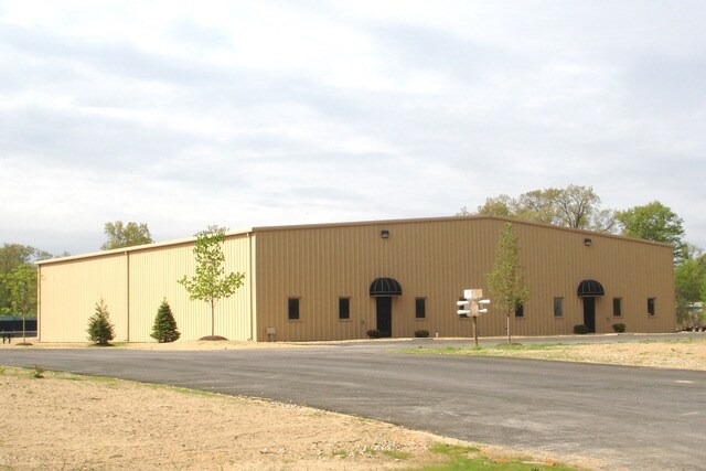
Property Record
10401 Industrial St, Swanton, OH 43558

NEARBY LISTINGS FOR SALE OR LEASE
Property Detail
10401 Industrial St
60-21182
9 8 35 SE 1/4 WLY 213.92 FT FRT ELY 1226.14 FTFRT NLY 407.34 FT AS
Regulatingdistrictsassessmentstaxabatement
Lucas
X
Ohio
39095C0206E
1.31 AC
2024
South/Southwest
2024
Toledo
009500
Toledo, OH
DEMOGRAPHICS near 10401 Industrial St
1 Mile
3 Mile
5 Mile
2024 Total Population
499
6,671
33,600
2029 Population
489
6,528
32,765
Pop Growth 2024-2029
(2.00%)
(2.14%)
(2.49%)
Average Age
44
44
43
2024 Total Households
194
2,544
13,017
HH Growth 2024-2029
(2.06%)
(2.28%)
(2.54%)
Median Household Inc
$39,582
$92,444
$91,439
Avg Household Size
2.50
2.50
2.50
2024 Avg HH Vehicles
2.00
2.00
2.00
Median Home Value
$316,667
$283,576
$260,980
Median Year Built
1979
1991
1988
Nearby Places
Map Layers
Map Styles
 Street
 Aerial
- Restaurants
- Banks
- Shops
- Fitness
- Groceries
PUBLIC TRANSPORTATION
AIRPORT
Eugene F Kranz Toledo Express
DRIVE
WALK
Distance
Eugene F Kranz Toledo Express
17 min
6.6 mi
Freight Ports
Port of Toledo
DRIVE
WALK
Distance
Port of Toledo
36 min
20.1 mi
Nearby Properties
Address
Land Use
TOTAL SIZE
Lot Size
Zoning
Address
Land Use
TOTAL SIZE
Lot Size
Zoning
178,278 SF
399.08 AC
33-A
Address
Land Use
TOTAL SIZE
Lot Size
Zoning
372,117 SF
35 AC
17-AR
Address
Land Use
TOTAL SIZE
Lot Size
Zoning
1,176 SF
626.54 AC
17-AR
Address
Land Use
TOTAL SIZE
Lot Size
Zoning
262.63 AC
33-MX
Address
Land Use
TOTAL SIZE
Lot Size
Zoning
131,800 SF
9.55 AC
33-M1
Address
Land Use
TOTAL SIZE
Lot Size
Zoning
106,687 SF
11.48 AC
19-RA3
Address
Land Use
TOTAL SIZE
Lot Size
Zoning
587,559 SF
45 AC
30-M1
Address
Land Use
TOTAL SIZE
Lot Size
Zoning
21.09 AC
33-A
Address
Land Use
TOTAL SIZE
Lot Size
Zoning
45.57 AC
30-M1
Address
Land Use
TOTAL SIZE
Lot Size
Zoning
77,220 SF
262.63 AC
33-MX
Address
Land Use
TOTAL SIZE
Lot Size
Zoning
69,061 SF
7.50 AC
19-RA3
Address
Land Use
TOTAL SIZE
Lot Size
Zoning
323,240 SF
21.09 AC
33-A
Address
Land Use
TOTAL SIZE
Lot Size
Zoning
100,000 SF
6.70 AC
33-M1
Address
Land Use
TOTAL SIZE
Lot Size
Zoning
35,520 SF
122 AC
19-RA4
Address
Land Use
TOTAL SIZE
Lot Size
Zoning
102,232 SF
6.29 AC
33-MX
Address
Land Use
TOTAL SIZE
Lot Size
Zoning
47,887 SF
12.27 AC
19-PO
Address
Land Use
TOTAL SIZE
Lot Size
Zoning
68,395 SF
398.85 AC
33-A
Address
Land Use
TOTAL SIZE
Lot Size
Zoning
59,900 SF
6.06 AC
30-M1
Address
Land Use
TOTAL SIZE
Lot Size
Zoning
665.87 AC
17-AR
Address
Land Use
TOTAL SIZE
Lot Size
Zoning
30,012 SF
3.44 AC
19-RA3
Address
Land Use
TOTAL SIZE
Lot Size
Zoning
89,700 SF
13.52 AC
19-MX
Address
Land Use
TOTAL SIZE
Lot Size
Zoning
28,760 SF
2.31 AC
19-C2
Address
Land Use
TOTAL SIZE
Lot Size
Zoning
78,149 SF
5.06 AC
30-M1
Address
Land Use
TOTAL SIZE
Lot Size
Zoning
41,816 SF
18.09 AC
19-M1
Address
Land Use
TOTAL SIZE
Lot Size
Zoning
58,438 SF
398.85 AC
33-A
Address
Land Use
TOTAL SIZE
Lot Size
Zoning
27,412 SF
1 AC
17-C2
Address
Land Use
TOTAL SIZE
Lot Size
Zoning
32,704 SF
1.18 AC
33-A
Address
Land Use
TOTAL SIZE
Lot Size
Zoning
37,432 SF
5.05 AC
19-RA3
Address
Land Use
TOTAL SIZE
Lot Size
Zoning
46,149 SF
5.68 AC
30-M1
Address
Land Use
TOTAL SIZE
Lot Size
Zoning
6,603 SF
37.77 AC
30-A
The World's #1 Commercial Real Estate Marketplace
Connect with us
© 2025 CoStar Group
The information above has been obtained from sources believed reliable. While we do not doubt its accuracy we have not verified it and make no guarantee, warranty or representation about it. It is your responsibility to independently confirm its accuracy and completeness. Any projections, opinions, assumptions, or estimates used are for example only and do not represent the current or future performance of the property. The value of this transaction to you depends on tax and other factors which should be evaluated by your tax, financial, and legal advisors. You and your advisors should conduct a careful, independent investigation of the property to determine to your satisfaction the suitability of the property for your needs.