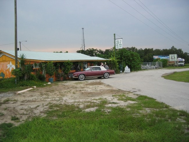
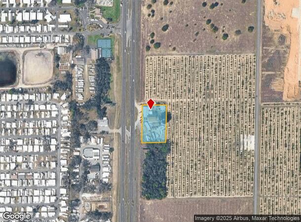
Property Record
10404 Us Highway 27 S, Sebring, FL 33876
NEARBY LISTINGS FOR SALE OR LEASE
-
-
View all Sebring listings for sale on LoopNet.com
Property Detail
10404 Us Highway 27 S
C-27-35-29-A00-0140-0000
N 262 FT OF NW 1/4 OF NW 1/4 OF SW 1/4 E OF HIWAY 27
Commercialnec
Highlands
X
Florida
12055C0243C
1.02 AC
2024
Florida Central South Area
2025
Other Market Areas
961000
Sebring, FL
3,232 SF
DEMOGRAPHICS near 10404 Us Highway 27 S
1 Mile
3 Mile
5 Mile
2024 Total Population
1,785
4,864
16,776
2029 Population
2,036
5,361
18,387
Pop Growth 2024-2029
+ 14.06%
+ 10.22%
+ 9.60%
Average Age
66
55
52
2024 Total Households
947
2,254
7,666
HH Growth 2024-2029
+ 14.36%
+ 10.74%
+ 9.78%
Median Household Inc
$45,345
$54,972
$41,934
Avg Household Size
1.90
2.10
2.10
2024 Avg HH Vehicles
1.00
2.00
2.00
Median Home Value
$65,309
$125,055
$156,202
Median Year Built
1989
1988
1986
Nearby Places
Map Layers
Map Styles
 Street
 Aerial
- Restaurants
- Banks
- Shops
- Fitness
- Groceries
PUBLIC TRANSPORTATION
COMMUTER RAIL
Sebring Amtrak Station (Silver Meteor - Amtrak, Silver Star - Amtrak)
DRIVE
WALK
Distance
Sebring Amtrak Station (Silver Meteor - Amtrak, Silver Star - Amtrak)
12 min
6.8 mi
Freight Ports
Port Manatee
DRIVE
WALK
Distance
Port Manatee
111 min
82.2 mi
SALE & LEASE HISTORY
LISTING DATE
SALE/LEASE

Nov 22, 2016
For Sale
Nearby Properties
Address
Land Use
TOTAL SIZE
Lot Size
Zoning
Address
Land Use
TOTAL SIZE
Lot Size
Zoning
70,602 SF
50 AC
PU
Address
Land Use
TOTAL SIZE
Lot Size
Zoning
113,523 SF
11.38 AC
R1
Address
Land Use
TOTAL SIZE
Lot Size
Zoning
49,298 SF
33.38 AC
PU
Address
Land Use
TOTAL SIZE
Lot Size
Zoning
4,693 SF
13.79 AC
CG1
Address
Land Use
TOTAL SIZE
Lot Size
Zoning
28,360 SF
13.47 AC
B3
Address
Land Use
TOTAL SIZE
Lot Size
Zoning
21,336 SF
1.80 AC
PU
Address
Land Use
TOTAL SIZE
Lot Size
Zoning
30,967 SF
43.49 AC
AU
Address
Land Use
TOTAL SIZE
Lot Size
Zoning
42,026 SF
9.98 AC
PU
Address
Land Use
TOTAL SIZE
Lot Size
Zoning
3,623 SF
9.64 AC
CG3
Address
Land Use
TOTAL SIZE
Lot Size
Zoning
19,362 SF
1.38 AC
B3
Address
Land Use
TOTAL SIZE
Lot Size
Zoning
47,660 SF
5.90 AC
AU
Address
Land Use
TOTAL SIZE
Lot Size
Zoning
7,452 SF
1.29 AC
B2
Address
Land Use
TOTAL SIZE
Lot Size
Zoning
13,987 SF
3.44 AC
AU
Address
Land Use
TOTAL SIZE
Lot Size
Zoning
5,962 SF
3.79 AC
B3
Address
Land Use
TOTAL SIZE
Lot Size
Zoning
31,480 SF
1.68 AC
B3
Address
Land Use
TOTAL SIZE
Lot Size
Zoning
18,800 SF
3.50 AC
B3
Address
Land Use
TOTAL SIZE
Lot Size
Zoning
10,710 SF
6.55 AC
I1
Address
Land Use
TOTAL SIZE
Lot Size
Zoning
13,648 SF
5.75 AC
B3
Address
Land Use
TOTAL SIZE
Lot Size
Zoning
8,580 SF
9.09 AC
I2
Address
Land Use
TOTAL SIZE
Lot Size
Zoning
11,001 SF
1.22 AC
B3
Address
Land Use
TOTAL SIZE
Lot Size
Zoning
7,918 SF
1.24 AC
B3
Address
Land Use
TOTAL SIZE
Lot Size
Zoning
12,000 SF
2.77 AC
I2
Address
Land Use
TOTAL SIZE
Lot Size
Zoning
9,230 SF
1.54 AC
B3
Address
Land Use
TOTAL SIZE
Lot Size
Zoning
8,108 SF
1.52 AC
R3
Address
Land Use
TOTAL SIZE
Lot Size
Zoning
2,494 SF
1.48 AC
B3
Address
Land Use
TOTAL SIZE
Lot Size
Zoning
15,000 SF
1.99 AC
B3
Address
Land Use
TOTAL SIZE
Lot Size
Zoning
9,600 SF
1.85 AC
B3
Address
Land Use
TOTAL SIZE
Lot Size
Zoning
172.15 AC
AU
Address
Land Use
TOTAL SIZE
Lot Size
Zoning
4,500 SF
2.09 AC
B3
Address
Land Use
TOTAL SIZE
Lot Size
Zoning
2,104 SF
510.30 AC
I1
The World's #1 Commercial Real Estate Marketplace
Connect with us
© 2025 CoStar Group
The information above has been obtained from sources believed reliable. While we do not doubt its accuracy we have not verified it and make no guarantee, warranty or representation about it. It is your responsibility to independently confirm its accuracy and completeness. Any projections, opinions, assumptions, or estimates used are for example only and do not represent the current or future performance of the property. The value of this transaction to you depends on tax and other factors which should be evaluated by your tax, financial, and legal advisors. You and your advisors should conduct a careful, independent investigation of the property to determine to your satisfaction the suitability of the property for your needs.