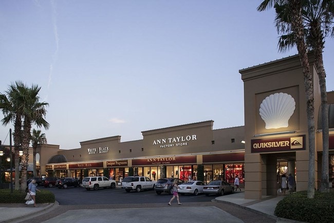
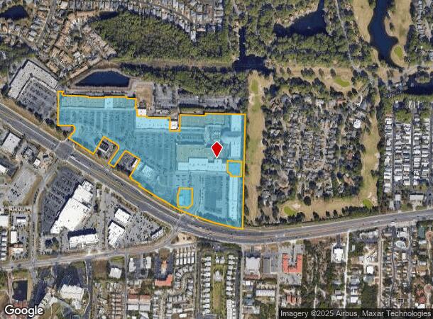
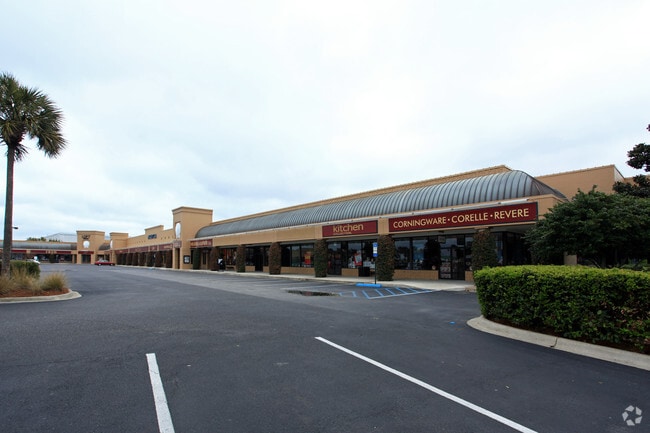
Property Record
10406 Us Highway 98 W, Miramar Beach, FL 32550
NEARBY LISTINGS FOR SALE OR LEASE
Property Detail
10406 Us Highway 98 W
28-2S-21-42000-001-0000
PARCEL 1 DESCRIBED AS: COM SE/COR SEC 28-2S-21W,N 01 DEG 1558E 85.99 FTTO N/LY ROW ST RD 30 FOR POB,N 01 DEG 1558E 667.34 FT,N 75 DEG 50 38W 671.92 FT,S 01 DEG 1558 W 650.03 FT TO CURVED ROW ST RD 30 (US 98 BYPASS)RADIUS 1809.86 FT,SE/LY ALONG CURVE
Regionalshoppingcenterormallwithanchorstore
Walton
X
Florida
12131C0538H
23.38 AC
2025
Fort Walton Beach
2025
Other Market Areas
950609
Crestview-Fort Walton Beach-Destin, FL
429,135 SF
DEMOGRAPHICS near 10406 Us Highway 98 W
1 Mile
3 Mile
5 Mile
2024 Total Population
4,575
16,492
27,228
2029 Population
6,096
21,815
34,386
Pop Growth 2024-2029
+ 33.25%
+ 32.28%
+ 26.29%
Average Age
54
52
48
2024 Total Households
2,318
7,973
12,424
HH Growth 2024-2029
+ 33.95%
+ 33.25%
+ 27.41%
Median Household Inc
$71,466
$71,471
$84,261
Avg Household Size
2.00
2.00
2.10
2024 Avg HH Vehicles
1.00
2.00
2.00
Median Home Value
$443,125
$491,639
$495,059
Median Year Built
1995
1999
2000
Nearby Places
Map Layers
Map Styles
 Street
 Aerial
- Restaurants
- Banks
- Shops
- Fitness
- Groceries
PUBLIC TRANSPORTATION
AIRPORT
Eglin AFB/Destin-Ft Walton Beach
DRIVE
WALK
Distance
Eglin AFB/Destin-Ft Walton Beach
54 min
22.7 mi
Freight Ports
Port of Panama City
DRIVE
WALK
Distance
Port of Panama City
64 min
41.7 mi
Nearby Properties
Address
Land Use
TOTAL SIZE
Lot Size
Zoning
Address
Land Use
TOTAL SIZE
Lot Size
Zoning
437,780 SF
9.40 AC
SD
Address
Land Use
TOTAL SIZE
Lot Size
Zoning
267,405 SF
1.54 AC
Address
Land Use
TOTAL SIZE
Lot Size
Zoning
269,575 SF
5.60 AC
SD
Address
Land Use
TOTAL SIZE
Lot Size
Zoning
399,449 SF
32.23 AC
SMNBHD
Address
Land Use
TOTAL SIZE
Lot Size
Zoning
5.19 AC
GULFFR
Address
Land Use
TOTAL SIZE
Lot Size
Zoning
218,504 SF
11.87 AC
HWY 98
Address
Land Use
TOTAL SIZE
Lot Size
Zoning
195,860 SF
14.03 AC
HWY 98
Address
Land Use
TOTAL SIZE
Lot Size
Zoning
182,539 SF
2.60 AC
SD
Address
Land Use
TOTAL SIZE
Lot Size
Zoning
138,905 SF
4.01 AC
Address
Land Use
TOTAL SIZE
Lot Size
Zoning
205,627 SF
34.20 AC
HWY 98
Address
Land Use
TOTAL SIZE
Lot Size
Zoning
115,433 SF
0.96 AC
Address
Land Use
TOTAL SIZE
Lot Size
Zoning
118,963 SF
7.58 AC
Address
Land Use
TOTAL SIZE
Lot Size
Zoning
74,662 SF
6.02 AC
HWY 98
Address
Land Use
TOTAL SIZE
Lot Size
Zoning
97,373 SF
12.83 AC
HWY 98
Address
Land Use
TOTAL SIZE
Lot Size
Zoning
135,599 SF
1.21 AC
HWY 98
Address
Land Use
TOTAL SIZE
Lot Size
Zoning
9,534 SF
12.45 AC
BAYS
Address
Land Use
TOTAL SIZE
Lot Size
Zoning
65,340 SF
1.01 AC
CCMU
Address
Land Use
TOTAL SIZE
Lot Size
Zoning
87,959 SF
2.76 AC
HWY 98
Address
Land Use
TOTAL SIZE
Lot Size
Zoning
66,001 SF
1.25 AC
HWY 98
Address
Land Use
TOTAL SIZE
Lot Size
Zoning
1,500 SF
241.13 AC
Address
Land Use
TOTAL SIZE
Lot Size
Zoning
18,731 SF
10.15 AC
GULFFR
Address
Land Use
TOTAL SIZE
Lot Size
Zoning
1.81 AC
GULFFR
Address
Land Use
TOTAL SIZE
Lot Size
Zoning
67,668 SF
1.56 AC
Address
Land Use
TOTAL SIZE
Lot Size
Zoning
123,120 SF
4.11 AC
HWY 98
Address
Land Use
TOTAL SIZE
Lot Size
Zoning
7,416 SF
25.45 AC
HWY 98
Address
Land Use
TOTAL SIZE
Lot Size
Zoning
68,849 SF
6.75 AC
HWY 98
Address
Land Use
TOTAL SIZE
Lot Size
Zoning
28,703 SF
0.78 AC
VMU
Address
Land Use
TOTAL SIZE
Lot Size
Zoning
50,665 SF
5.47 AC
Address
Land Use
TOTAL SIZE
Lot Size
Zoning
89,369 SF
6.54 AC
HWY 98
The World's #1 Commercial Real Estate Marketplace
Connect with us
© 2026 CoStar Group
The information above has been obtained from sources believed reliable. While we do not doubt its accuracy we have not verified it and make no guarantee, warranty or representation about it. It is your responsibility to independently confirm its accuracy and completeness. Any projections, opinions, assumptions, or estimates used are for example only and do not represent the current or future performance of the property. The value of this transaction to you depends on tax and other factors which should be evaluated by your tax, financial, and legal advisors. You and your advisors should conduct a careful, independent investigation of the property to determine to your satisfaction the suitability of the property for your needs.