Property Record
1041 Cannons Ct, Woodbridge, VA 22191


Save to a Folder
{{folder.Name}}
{{folder.ListingIds.length}} Properties
{{folder.ListingIds.length}} Property
Create a New Folder
Property Detail
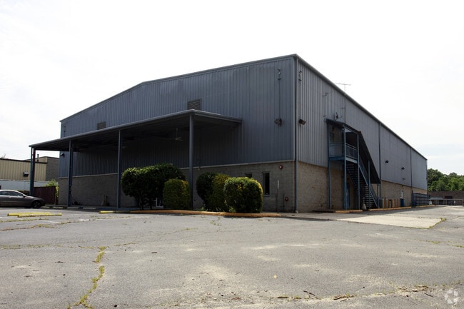
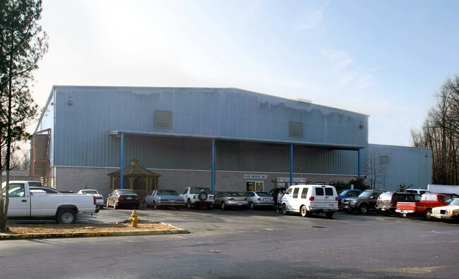
1041 Cannons Ct
8492-02-6712
DAWSON BEACH
Storebuilding
Prince William
M1
Virginia
C and X Area of minimal flood hazard, usually depicted on FIRMs as above the 500-year flood level.
6712
2024
3.09 AC
2025
Woodbridge
900100
Washington, DC
21,424 SF
Washington-Arlington-Alexandria, DC-VA-MD-WV
NEARBY LISTINGS FOR SALE OR LEASE
DEMOGRAPHICS near 1041 Cannons Ct
1 mile
3 mile
5 mile
2025 Total Population
12,493
67,848
177,457
2030 Population
12,891
69,608
181,777
Pop Growth 2025-2030
+ 3.19%
+ 2.59%
+ 2.43%
Average Age
37
37
37
2025 Total Households
4,154
23,688
58,471
HH Growth 2025-2030
+ 3.18%
+ 2.63%
+ 2.39%
Median Household Inc
$111,291
$102,568
$114,663
Avg Household Size
2.90
2.80
2.90
2025 Avg HH Vehicles
2.00
2.00
2.00
Median Home Value
$459,438
$422,071
$460,252
Median Year Built
1992
1989
1989
Nearby Places
Map Layers
Map Styles
 Street
 Aerial
Layers
 Traffic
 Biking
Places
Listings with unknown addresses are not visible on the map
- Restaurants
- Banks
- Shops
- Fitness
- Groceries
PUBLIC TRANSPORTATION
TRANSIT/SUBWAY
Woodbridge (Fredericksburg Line - Virginia Railway Express)
Drive
Walk
Distance
Woodbridge (Fredericksburg Line - Virginia Railway Express)
3 min
18 min
0.9 mi
COMMUTER RAIL
Woodbridge (Fredericksburg Line - Virginia Railway Express)
Drive
Walk
Distance
Woodbridge (Fredericksburg Line - Virginia Railway Express)
3 min
19 min
0.9 mi
Drive
Walk
Distance
12 min
5.0 mi
AIRPORT
Ronald Reagan Washington Ntl
Drive
Walk
Distance
Ronald Reagan Washington Ntl
34 min
21.0 mi
Washington Dulles International
Drive
Walk
Distance
Washington Dulles International
55 min
30.6 mi
Freight Ports
Port of Baltimore
Drive
Walk
Distance
Port of Baltimore
91 min
62.0 mi
Nearby Properties
Address
Land Use
TOTAL SIZE
Lot Size
Zoning
Address
Land Use
TOTAL SIZE
Lot Size
Zoning
1,402,177 SF
104.72 AC
B1
Address
Land Use
TOTAL SIZE
Lot Size
Zoning
570,195 SF
38.70 AC
OH
Address
Land Use
TOTAL SIZE
Lot Size
Zoning
485,714 SF
82.68 AC
MIXED
Address
Land Use
TOTAL SIZE
Lot Size
Zoning
609,447 SF
44.24 AC
R16
Address
Land Use
TOTAL SIZE
Lot Size
Zoning
660,280 SF
10.80 AC
RPC
Address
Land Use
TOTAL SIZE
Lot Size
Zoning
872,283 SF
17.34 AC
PMR
Address
Land Use
TOTAL SIZE
Lot Size
Zoning
465,616 SF
6.45 AC
PMR
Address
Land Use
TOTAL SIZE
Lot Size
Zoning
345,910 SF
18.78 AC
PMR
Address
Land Use
TOTAL SIZE
Lot Size
Zoning
337,789 SF
10.02 AC
PMD
Address
Land Use
TOTAL SIZE
Lot Size
Zoning
568,505 SF
7.19 AC
PMR
Address
Land Use
TOTAL SIZE
Lot Size
Zoning
377,248 SF
26.67 AC
R16
Address
Land Use
TOTAL SIZE
Lot Size
Zoning
93,321 SF
26.28 AC
R16
Address
Land Use
TOTAL SIZE
Lot Size
Zoning
175,001 SF
28.60 AC
R16
Address
Land Use
TOTAL SIZE
Lot Size
Zoning
605,863 SF
14.52 AC
PMD
Address
Land Use
TOTAL SIZE
Lot Size
Zoning
81,628 SF
26.25 AC
R16
Address
Land Use
TOTAL SIZE
Lot Size
Zoning
189,313 SF
18.44 AC
R16
Address
Land Use
TOTAL SIZE
Lot Size
Zoning
316,829 SF
8.96 AC
PMR
Address
Land Use
TOTAL SIZE
Lot Size
Zoning
281,041 SF
76.93 AC
MIXED
Address
Land Use
TOTAL SIZE
Lot Size
Zoning
354,638 SF
28.32 AC
B1
Address
Land Use
TOTAL SIZE
Lot Size
Zoning
86,869 SF
9.54 AC
PMD
Address
Land Use
TOTAL SIZE
Lot Size
Zoning
376,424 SF
24.48 AC
R16
Address
Land Use
TOTAL SIZE
Lot Size
Zoning
424,533 SF
14.74 AC
R16
Address
Land Use
TOTAL SIZE
Lot Size
Zoning
252,614 SF
21.96 AC
B1
Address
Land Use
TOTAL SIZE
Lot Size
Zoning
434,095 SF
18.64 AC
B1
Address
Land Use
TOTAL SIZE
Lot Size
Zoning
120,620 SF
13.10 AC
596
Address
Land Use
TOTAL SIZE
Lot Size
Zoning
199,448 SF
6.14 AC
R30
Address
Land Use
TOTAL SIZE
Lot Size
Zoning
67,551 SF
12.69 AC
R16
Address
Land Use
TOTAL SIZE
Lot Size
Zoning
223,340 SF
20.64 AC
MIXED
Address
Land Use
TOTAL SIZE
Lot Size
Zoning
170,328 SF
13.21 AC
R16
Address
Land Use
TOTAL SIZE
Lot Size
Zoning
120,203 SF
17.35 AC
MIXED
The World's #1 Commercial Real Estate Marketplace
Connect with us
© 2026 CoStar Group
The information above has been obtained from sources believed reliable. While we do not doubt its accuracy we have not verified it and make no guarantee, warranty or representation about it. It is your responsibility to independently confirm its accuracy and completeness. Any projections, opinions, assumptions, or estimates used are for example only and do not represent the current or future performance of the property. The value of this transaction to you depends on tax and other factors which should be evaluated by your tax, financial, and legal advisors. You and your advisors should conduct a careful, independent investigation of the property to determine to your satisfaction the suitability of the property for your needs.