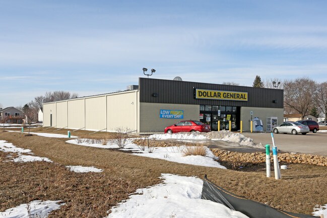
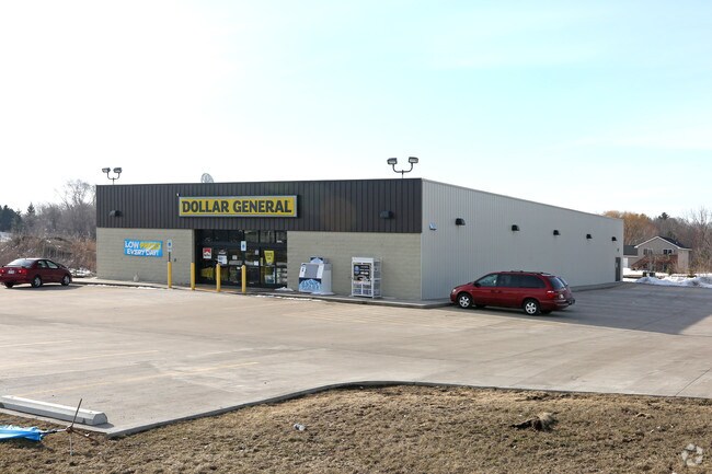
Property Record
1041 Orrin Rd, Prescott, WI 54021

Property Detail
1041 Orrin Rd
Minneapolis-St. Paul-Bloomington, MN-WI
LOT 1 CSM V 14 P 37 CONT 1.234 A PRT OF FORMER LOT 1 CSM V 11 P 155 BEING PRT OF NE 1/4 OF NW 1/4 (FORMERLY PRT OF LOT 9 BL
271-01002-2401
Pierce
Commercialnec
Wisconsin
B and X Area of moderate flood hazard, usually the area between the limits of the 100-year and 500-year floods.
1
2025
1.23 AC
2025
Pierce County
960500
Minneapolis/St Paul
NEARBY LISTINGS FOR SALE OR LEASE
-
-
View all Prescott listings for sale on LoopNet.com
DEMOGRAPHICS near 1041 Orrin Rd
1 mile
3 mile
5 mile
2025 Total Population
3,789
7,186
29,288
2030 Population
3,898
7,432
30,169
Pop Growth 2025-2030
+ 2.88%
+ 3.42%
+ 3.01%
Average Age
40
41
42
2025 Total Households
1,517
2,876
11,910
HH Growth 2025-2030
+ 2.70%
+ 3.41%
+ 3.02%
Median Household Inc
$93,404
$94,932
$94,413
Avg Household Size
2.40
2.40
2.40
2025 Avg HH Vehicles
2.00
2.00
2.00
Median Home Value
$324,564
$347,495
$335,364
Median Year Built
1983
1984
1984
Nearby Places
Map Layers
Map Styles
 Street
 Aerial
Transit
 Traffic
 Biking
Places
Listings with unknown addresses are not visible on the map
- Restaurants
- Banks
- Shops
- Fitness
- Groceries
PUBLIC TRANSPORTATION
AIRPORT
Minneapolis-St Paul International/Wold-Chamberlain
Drive
Walk
Distance
Minneapolis-St Paul International/Wold-Chamberlain
40 min
28.4 mi
Nearby Properties
Address
Land Use
TOTAL SIZE
Lot Size
Zoning
Address
Land Use
TOTAL SIZE
Lot Size
Zoning
42.33 AC
Address
Land Use
TOTAL SIZE
Lot Size
Zoning
109,735 SF
1.12 AC
Address
Land Use
TOTAL SIZE
Lot Size
Zoning
115,394 SF
4.74 AC
Address
Land Use
TOTAL SIZE
Lot Size
Zoning
49,091 SF
1.27 AC
Address
Land Use
TOTAL SIZE
Lot Size
Zoning
11,496 SF
81.36 AC
Address
Land Use
TOTAL SIZE
Lot Size
Zoning
303,706 SF
5.19 AC
Address
Land Use
TOTAL SIZE
Lot Size
Zoning
98,580 SF
7.97 AC
Address
Land Use
TOTAL SIZE
Lot Size
Zoning
2,076 SF
Address
Land Use
TOTAL SIZE
Lot Size
Zoning
1,460 SF
35.71 AC
Address
Land Use
TOTAL SIZE
Lot Size
Zoning
2,980 SF
Address
Land Use
TOTAL SIZE
Lot Size
Zoning
3,949 SF
Address
Land Use
TOTAL SIZE
Lot Size
Zoning
19,828 SF
0.28 AC
Address
Land Use
TOTAL SIZE
Lot Size
Zoning
16,304 SF
29.12 AC
Address
Land Use
TOTAL SIZE
Lot Size
Zoning
1,902 SF
88.83 AC
Address
Land Use
TOTAL SIZE
Lot Size
Zoning
1,514 SF
Address
Land Use
TOTAL SIZE
Lot Size
Zoning
3,159 SF
44.01 AC
Address
Land Use
TOTAL SIZE
Lot Size
Zoning
13,440 SF
0.10 AC
Address
Land Use
TOTAL SIZE
Lot Size
Zoning
159.67 AC
Address
Land Use
TOTAL SIZE
Lot Size
Zoning
26,000 SF
2.18 AC
Address
Land Use
TOTAL SIZE
Lot Size
Zoning
2,256 SF
43.85 AC
Address
Land Use
TOTAL SIZE
Lot Size
Zoning
1,474 SF
33.30 AC
Address
Land Use
TOTAL SIZE
Lot Size
Zoning
2.24 AC
Address
Land Use
TOTAL SIZE
Lot Size
Zoning
1.07 AC
Address
Land Use
TOTAL SIZE
Lot Size
Zoning
Address
Land Use
TOTAL SIZE
Lot Size
Zoning
3.06 AC
Address
Land Use
TOTAL SIZE
Lot Size
Zoning
1,632 SF
39.71 AC
Address
Land Use
TOTAL SIZE
Lot Size
Zoning
3.31 AC
Address
Land Use
TOTAL SIZE
Lot Size
Zoning
1.14 AC
Address
Land Use
TOTAL SIZE
Lot Size
Zoning
1,753 SF
32.93 AC
The World's #1 Commercial Real Estate Marketplace
Connect with us
© 2026 CoStar Group
The information above has been obtained from sources believed reliable. While we do not doubt its accuracy we have not verified it and make no guarantee, warranty or representation about it. It is your responsibility to independently confirm its accuracy and completeness. Any projections, opinions, assumptions, or estimates used are for example only and do not represent the current or future performance of the property. The value of this transaction to you depends on tax and other factors which should be evaluated by your tax, financial, and legal advisors. You and your advisors should conduct a careful, independent investigation of the property to determine to your satisfaction the suitability of the property for your needs.