Property Record
1041 S Pershing Ave, Stockton, CA 95206
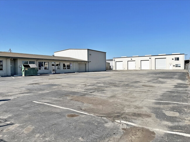

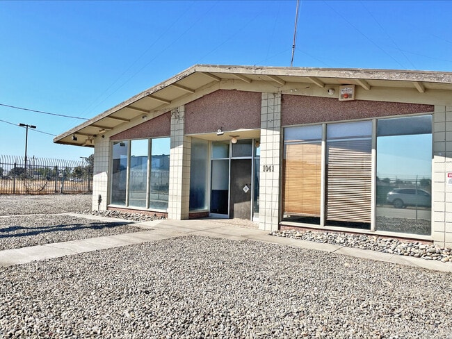

This Property Is For Sale
Current Lease Availabilities
Property Detail
1041 S Pershing Ave
Stockton-Lodi, CA
REDRAW 871102 FR ORIG APN 163030471
163-300-18
San Joaquin
Lightindustrial
California
2025
c
2025
1.07 AC
000803
West Stockton
5,670 SF
Stockton/Modesto
NEARBY LISTINGS FOR SALE OR LEASE
DEMOGRAPHICS near 1041 S Pershing Ave
1 mile
3 mile
5 mile
2025 Total Population
12,522
130,583
253,245
2030 Population
13,127
135,990
263,638
Pop Growth 2025-2030
+ 4.83%
+ 4.14%
+ 4.10%
Average Age
36
36
36
2025 Total Households
3,049
38,913
77,650
HH Growth 2025-2030
+ 5.31%
+ 4.52%
+ 4.35%
Median Household Inc
$77,537
$67,046
$70,211
Avg Household Size
3.60
3.10
3.10
2025 Avg HH Vehicles
2.00
2.00
2.00
Median Home Value
$376,070
$384,582
$398,290
Median Year Built
1989
1964
1972
Nearby Places
Map Layers
Map Styles
 Street
 Aerial
Layers
 Traffic
 Biking
Places
Listings with unknown addresses are not visible on the map
- Restaurants
- Banks
- Shops
- Fitness
- Groceries
PUBLIC TRANSPORTATION
COMMUTER RAIL
Stockton (San Joaquins - Amtrak)
Drive
Walk
Distance
Stockton (San Joaquins - Amtrak)
5 min
1.9 mi
Stockton- Robert J Cabral Station (ACE Train - Altamont Corridor Express)
Drive
Walk
Distance
Stockton- Robert J Cabral Station (ACE Train - Altamont Corridor Express)
6 min
3.1 mi
AIRPORT
Stockton Metro
Drive
Walk
Distance
Stockton Metro
11 min
6.3 mi
Freight Ports
Port of Stockton
Drive
Walk
Distance
Port of Stockton
7 min
3.8 mi
Nearby Properties
Address
Land Use
TOTAL SIZE
Lot Size
Zoning
Address
Land Use
TOTAL SIZE
Lot Size
Zoning
530,700 SF
8.35 AC
Address
Land Use
TOTAL SIZE
Lot Size
Zoning
152,000 SF
1.31 AC
Address
Land Use
TOTAL SIZE
Lot Size
Zoning
4.78 AC
Address
Land Use
TOTAL SIZE
Lot Size
Zoning
656,200 SF
24.07 AC
IG
Address
Land Use
TOTAL SIZE
Lot Size
Zoning
10,208 SF
47.57 AC
Address
Land Use
TOTAL SIZE
Lot Size
Zoning
502,000 SF
19.76 AC
Address
Land Use
TOTAL SIZE
Lot Size
Zoning
512,000 SF
20.16 AC
Address
Land Use
TOTAL SIZE
Lot Size
Zoning
69,954 SF
24.92 AC
Address
Land Use
TOTAL SIZE
Lot Size
Zoning
586,610 SF
27.36 AC
Address
Land Use
TOTAL SIZE
Lot Size
Zoning
328,500 SF
12.27 AC
Address
Land Use
TOTAL SIZE
Lot Size
Zoning
295,680 SF
37.65 AC
Address
Land Use
TOTAL SIZE
Lot Size
Zoning
277,300 SF
13.32 AC
Address
Land Use
TOTAL SIZE
Lot Size
Zoning
82,512 SF
4.14 AC
Address
Land Use
TOTAL SIZE
Lot Size
Zoning
247,850 SF
9.48 AC
Address
Land Use
TOTAL SIZE
Lot Size
Zoning
63,975 SF
6.60 AC
Address
Land Use
TOTAL SIZE
Lot Size
Zoning
23.30 AC
Address
Land Use
TOTAL SIZE
Lot Size
Zoning
8,000 SF
0.67 AC
Address
Land Use
TOTAL SIZE
Lot Size
Zoning
0.79 AC
Address
Land Use
TOTAL SIZE
Lot Size
Zoning
46.75 AC
Address
Land Use
TOTAL SIZE
Lot Size
Zoning
37,846 SF
2.94 AC
Address
Land Use
TOTAL SIZE
Lot Size
Zoning
17,573 SF
3.17 AC
Address
Land Use
TOTAL SIZE
Lot Size
Zoning
Address
Land Use
TOTAL SIZE
Lot Size
Zoning
8.58 AC
Address
Land Use
TOTAL SIZE
Lot Size
Zoning
39,210 SF
10.30 AC
IL
Address
Land Use
TOTAL SIZE
Lot Size
Zoning
7.40 AC
Address
Land Use
TOTAL SIZE
Lot Size
Zoning
2,880 SF
36.83 AC
Address
Land Use
TOTAL SIZE
Lot Size
Zoning
39,840 SF
30 AC
Address
Land Use
TOTAL SIZE
Lot Size
Zoning
84,895 SF
2.21 AC
The World's #1 Commercial Real Estate Marketplace
Connect with us
© 2026 CoStar Group
The information above has been obtained from sources believed reliable. While we do not doubt its accuracy we have not verified it and make no guarantee, warranty or representation about it. It is your responsibility to independently confirm its accuracy and completeness. Any projections, opinions, assumptions, or estimates used are for example only and do not represent the current or future performance of the property. The value of this transaction to you depends on tax and other factors which should be evaluated by your tax, financial, and legal advisors. You and your advisors should conduct a careful, independent investigation of the property to determine to your satisfaction the suitability of the property for your needs.