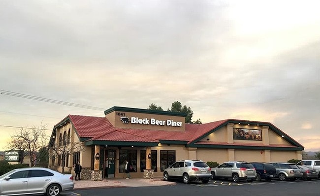
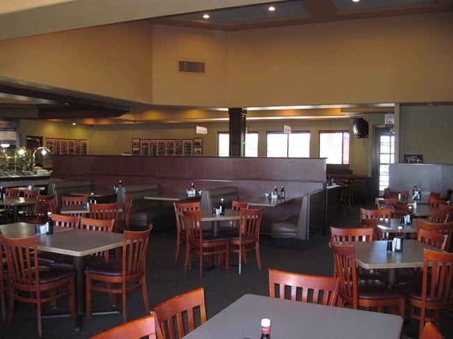
Property Record
1041 S State Route 260, Cottonwood, AZ 86326


NEARBY LISTINGS FOR SALE OR LEASE
Property Detail
1041 S State Route 260
Restaurantbuilding
IRREG PCL BY M&B LYNG 255.2 W OF NE COR OF & IN SE4 SW4 CONT 1.3 9AC SEC 2 15 3E
AE
Yavapai
04025C1757H
Arizona
2024
1.39 AC
2026
Other Market Areas
002003
Prescott, AZ
6,337 SF
406-04-056A
DEMOGRAPHICS near 1041 S State Route 260
1 Mile
3 Mile
5 Mile
2024 Total Population
4,006
25,471
31,591
2029 Population
4,378
28,065
34,692
Pop Growth 2024-2029
+ 9.29%
+ 10.18%
+ 9.82%
Average Age
45
46
46
2024 Total Households
1,760
11,050
13,859
HH Growth 2024-2029
+ 9.60%
+ 10.67%
+ 10.21%
Median Household Inc
$45,663
$51,553
$50,750
Avg Household Size
2.20
2.20
2.20
2024 Avg HH Vehicles
2.00
2.00
2.00
Median Home Value
$291,966
$297,244
$303,913
Median Year Built
1990
1990
1991
Nearby Places
Map Layers
Map Styles
 Street
 Aerial
- Restaurants
- Banks
- Shops
- Fitness
- Groceries
SALE & LEASE HISTORY
LISTING DATE
SALE/LEASE

Mar 14, 2017
For Sale
Jun 06, 2017
For Sale
Nearby Properties
Address
Land Use
TOTAL SIZE
Lot Size
Zoning
Address
Land Use
TOTAL SIZE
Lot Size
Zoning
394,211 SF
31.40 AC
Address
Land Use
TOTAL SIZE
Lot Size
Zoning
208,600 SF
20.55 AC
Address
Land Use
TOTAL SIZE
Lot Size
Zoning
178,867 SF
35.99 AC
Address
Land Use
TOTAL SIZE
Lot Size
Zoning
57,426 SF
7.51 AC
Address
Land Use
TOTAL SIZE
Lot Size
Zoning
136,092 SF
10.71 AC
Address
Land Use
TOTAL SIZE
Lot Size
Zoning
98,998 SF
23.75 AC
Address
Land Use
TOTAL SIZE
Lot Size
Zoning
83,809 SF
13.34 AC
Address
Land Use
TOTAL SIZE
Lot Size
Zoning
76,930 SF
9.38 AC
Address
Land Use
TOTAL SIZE
Lot Size
Zoning
103,490 SF
9.98 AC
Address
Land Use
TOTAL SIZE
Lot Size
Zoning
51,671 SF
1.42 AC
Address
Land Use
TOTAL SIZE
Lot Size
Zoning
30,680 SF
149.02 AC
Address
Land Use
TOTAL SIZE
Lot Size
Zoning
41,847 SF
18.21 AC
Address
Land Use
TOTAL SIZE
Lot Size
Zoning
48,863 SF
1.82 AC
Address
Land Use
TOTAL SIZE
Lot Size
Zoning
73,498 SF
2.74 AC
Address
Land Use
TOTAL SIZE
Lot Size
Zoning
16,984 SF
8.16 AC
Address
Land Use
TOTAL SIZE
Lot Size
Zoning
80,537 SF
1.14 AC
Address
Land Use
TOTAL SIZE
Lot Size
Zoning
103,962 SF
2.29 AC
Address
Land Use
TOTAL SIZE
Lot Size
Zoning
50,018 SF
2.16 AC
Address
Land Use
TOTAL SIZE
Lot Size
Zoning
67,063 SF
9.95 AC
Address
Land Use
TOTAL SIZE
Lot Size
Zoning
40,348 SF
3.92 AC
Address
Land Use
TOTAL SIZE
Lot Size
Zoning
30,312 SF
3.17 AC
Address
Land Use
TOTAL SIZE
Lot Size
Zoning
72,635 SF
21.58 AC
Address
Land Use
TOTAL SIZE
Lot Size
Zoning
40,241 SF
20.12 AC
Address
Land Use
TOTAL SIZE
Lot Size
Zoning
63,930 SF
6.56 AC
Address
Land Use
TOTAL SIZE
Lot Size
Zoning
50,338 SF
2.16 AC
Address
Land Use
TOTAL SIZE
Lot Size
Zoning
35,261 SF
3.94 AC
Address
Land Use
TOTAL SIZE
Lot Size
Zoning
74,940 SF
7.67 AC
Address
Land Use
TOTAL SIZE
Lot Size
Zoning
33,385 SF
6.16 AC
Address
Land Use
TOTAL SIZE
Lot Size
Zoning
24,460 SF
1.39 AC
Address
Land Use
TOTAL SIZE
Lot Size
Zoning
50,748 SF
6.41 AC
The World's #1 Commercial Real Estate Marketplace
Connect with us
© 2026 CoStar Group
The information above has been obtained from sources believed reliable. While we do not doubt its accuracy we have not verified it and make no guarantee, warranty or representation about it. It is your responsibility to independently confirm its accuracy and completeness. Any projections, opinions, assumptions, or estimates used are for example only and do not represent the current or future performance of the property. The value of this transaction to you depends on tax and other factors which should be evaluated by your tax, financial, and legal advisors. You and your advisors should conduct a careful, independent investigation of the property to determine to your satisfaction the suitability of the property for your needs.