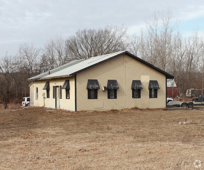
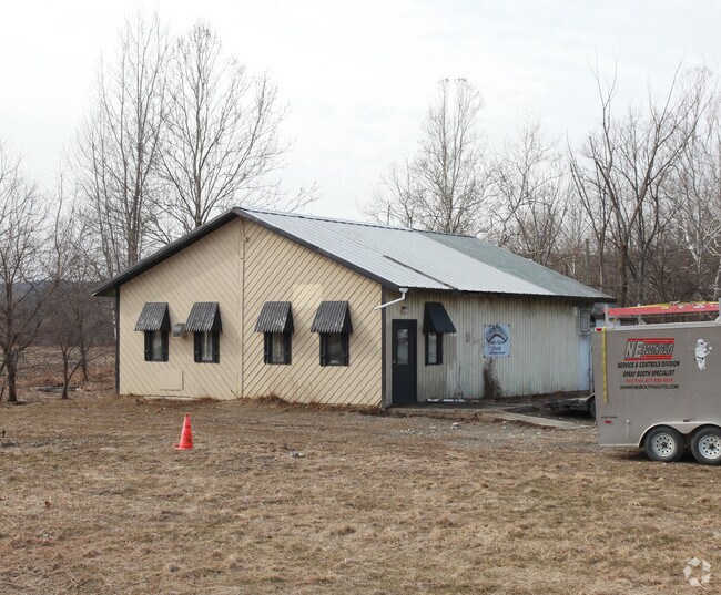
Property Record
1041 State Route 22, Cambridge, NY 12816

NEARBY LISTINGS FOR SALE OR LEASE
Property Detail
1041 State Route 22
Glens Falls, NY
STORAGE & VAC COMM BLDG
535089-264-000-0001-032-007-0000
Washington
Distributionwarehouseregional
New York
2025
32.007
2024
2.29 AC
091000
Washington County
920 SF
Albany/Schenectady/Troy
DEMOGRAPHICS near 1041 State Route 22
1 Mile
3 Mile
5 Mile
2024 Total Population
622
3,071
5,150
2029 Population
615
3,049
5,114
Pop Growth 2024-2029
(1.13%)
(0.72%)
(0.70%)
Average Age
44
44
44
2024 Total Households
267
1,315
2,139
HH Growth 2024-2029
(0.75%)
(0.68%)
(0.75%)
Median Household Inc
$58,749
$60,701
$67,698
Avg Household Size
2.30
2.30
2.30
2024 Avg HH Vehicles
2.00
2.00
2.00
Median Home Value
$179,310
$183,531
$195,788
Median Year Built
1951
1949
1958
Nearby Places
Map Layers
Map Styles
 Street
 Aerial
- Restaurants
- Banks
- Shops
- Fitness
- Groceries
PUBLIC TRANSPORTATION
AIRPORT
Albany International
DRIVE
WALK
Distance
Albany International
59 min
36.3 mi
Freight Ports
Albany, NY Port
DRIVE
WALK
Distance
Albany, NY Port
64 min
39.0 mi
Nearby Properties
Address
Land Use
TOTAL SIZE
Lot Size
Zoning
Address
Land Use
TOTAL SIZE
Lot Size
Zoning
184,610 SF
46.80 AC
RR
Address
Land Use
TOTAL SIZE
Lot Size
Zoning
980 SF
9.90 AC
VR
Address
Land Use
TOTAL SIZE
Lot Size
Zoning
11,984 SF
0.99 AC
MU
Address
Land Use
TOTAL SIZE
Lot Size
Zoning
2,880 SF
4.50 AC
Address
Land Use
TOTAL SIZE
Lot Size
Zoning
3,585 SF
2.80 AC
RT
Address
Land Use
TOTAL SIZE
Lot Size
Zoning
17,728 SF
4 AC
VR
Address
Land Use
TOTAL SIZE
Lot Size
Zoning
2,200 SF
0.59 AC
MU
Address
Land Use
TOTAL SIZE
Lot Size
Zoning
30,448 SF
9.80 AC
RR
Address
Land Use
TOTAL SIZE
Lot Size
Zoning
2,708 SF
0.82 AC
VR
Address
Land Use
TOTAL SIZE
Lot Size
Zoning
18,213 SF
14.70 AC
Address
Land Use
TOTAL SIZE
Lot Size
Zoning
28,307 SF
5.73 AC
01 - NOT Z
Address
Land Use
TOTAL SIZE
Lot Size
Zoning
21,565 SF
102.10 AC
RR
Address
Land Use
TOTAL SIZE
Lot Size
Zoning
5,364 SF
1.40 AC
RT
Address
Land Use
TOTAL SIZE
Lot Size
Zoning
Address
Land Use
TOTAL SIZE
Lot Size
Zoning
14,274 SF
2.95 AC
Address
Land Use
TOTAL SIZE
Lot Size
Zoning
22,696 SF
3.60 AC
VR
Address
Land Use
TOTAL SIZE
Lot Size
Zoning
4,273 SF
0.96 AC
MU
Address
Land Use
TOTAL SIZE
Lot Size
Zoning
44,747 SF
2.40 AC
I
Address
Land Use
TOTAL SIZE
Lot Size
Zoning
13.60 AC
Address
Land Use
TOTAL SIZE
Lot Size
Zoning
22,560 SF
1.74 AC
VR
Address
Land Use
TOTAL SIZE
Lot Size
Zoning
7,025 SF
4.70 AC
GC
Address
Land Use
TOTAL SIZE
Lot Size
Zoning
3,244 SF
16.86 AC
Address
Land Use
TOTAL SIZE
Lot Size
Zoning
27,963 SF
3.37 AC
Address
Land Use
TOTAL SIZE
Lot Size
Zoning
5,720 SF
2.10 AC
MU
Address
Land Use
TOTAL SIZE
Lot Size
Zoning
2,176 SF
0.65 AC
MU
Address
Land Use
TOTAL SIZE
Lot Size
Zoning
2,596 SF
0.50 AC
MU
Address
Land Use
TOTAL SIZE
Lot Size
Zoning
25,212 SF
4.47 AC
Address
Land Use
TOTAL SIZE
Lot Size
Zoning
419.20 AC
Address
Land Use
TOTAL SIZE
Lot Size
Zoning
24,921 SF
1.90 AC
I
Address
Land Use
TOTAL SIZE
Lot Size
Zoning
15,103 SF
5 AC
The World's #1 Commercial Real Estate Marketplace
Connect with us
© 2026 CoStar Group
The information above has been obtained from sources believed reliable. While we do not doubt its accuracy we have not verified it and make no guarantee, warranty or representation about it. It is your responsibility to independently confirm its accuracy and completeness. Any projections, opinions, assumptions, or estimates used are for example only and do not represent the current or future performance of the property. The value of this transaction to you depends on tax and other factors which should be evaluated by your tax, financial, and legal advisors. You and your advisors should conduct a careful, independent investigation of the property to determine to your satisfaction the suitability of the property for your needs.