Property Record
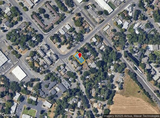
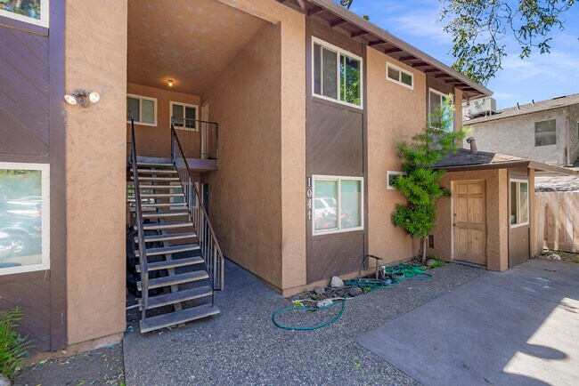
1041 W 9Th St, Chico, CA 95928


NEARBY LISTINGS FOR SALE OR LEASE
Property Detail
1041 W 9Th St
Chico, CA
Chico
004-290-015-000
1041 W. 9TH ST.
Quadruplex
Butte
AO
California
06007C0502E
6
2024
0.20 AC
2025
Downtown Chico
001100
Other Market Areas
4,416 SF
DEMOGRAPHICS near 1041 W 9Th St
1 Mile
3 Mile
5 Mile
2024 Total Population
12,185
63,645
104,788
2029 Population
11,649
60,629
100,200
Pop Growth 2024-2029
(4.40%)
(4.74%)
(4.38%)
Average Age
31
36
37
2024 Total Households
5,205
25,946
42,860
HH Growth 2024-2029
(4.55%)
(4.93%)
(4.58%)
Median Household Inc
$42,747
$60,415
$68,650
Avg Household Size
2.20
2.30
2.30
2024 Avg HH Vehicles
2.00
2.00
2.00
Median Home Value
$356,928
$401,701
$424,703
Median Year Built
1968
1976
1982
Nearby Places
Map Layers
Map Styles
 Street
 Aerial
- Restaurants
- Banks
- Shops
- Fitness
- Groceries
PUBLIC TRANSPORTATION
COMMUTER RAIL
Chico Amtrak (Coast Starlight - Amtrak)
DRIVE
WALK
Distance
Chico Amtrak (Coast Starlight - Amtrak)
1 min
7 min
0.4 mi
Freight Ports
Port of Stockton
DRIVE
WALK
Distance
Port of Stockton
160 min
131.7 mi
SALE & LEASE HISTORY
LISTING DATE
SALE/LEASE

Jul 20, 2022
For Sale
Nearby Properties
Address
Land Use
TOTAL SIZE
Lot Size
Zoning
Address
Land Use
TOTAL SIZE
Lot Size
Zoning
150,000 SF
2.31 AC
Address
Land Use
TOTAL SIZE
Lot Size
Zoning
135,668 SF
3.43 AC
PQ
Address
Land Use
TOTAL SIZE
Lot Size
Zoning
102,010 SF
12.55 AC
Address
Land Use
TOTAL SIZE
Lot Size
Zoning
194,612 SF
4.72 AC
R3
Address
Land Use
TOTAL SIZE
Lot Size
Zoning
32,880 SF
25.36 AC
Address
Land Use
TOTAL SIZE
Lot Size
Zoning
90,859 SF
5.60 AC
PQ
Address
Land Use
TOTAL SIZE
Lot Size
Zoning
20,643 SF
3.32 AC
TND
Address
Land Use
TOTAL SIZE
Lot Size
Zoning
84,280 SF
1.60 AC
R4
Address
Land Use
TOTAL SIZE
Lot Size
Zoning
133,120 SF
5.37 AC
R3
Address
Land Use
TOTAL SIZE
Lot Size
Zoning
1,189 SF
1.25 AC
A40
Address
Land Use
TOTAL SIZE
Lot Size
Zoning
61,571 SF
6.47 AC
Address
Land Use
TOTAL SIZE
Lot Size
Zoning
158,426 SF
16.19 AC
M1
Address
Land Use
TOTAL SIZE
Lot Size
Zoning
1.58 AC
Address
Land Use
TOTAL SIZE
Lot Size
Zoning
247,613 SF
10.77 AC
CR
Address
Land Use
TOTAL SIZE
Lot Size
Zoning
160,214 SF
13.50 AC
Address
Land Use
TOTAL SIZE
Lot Size
Zoning
160,354 SF
11.39 AC
00
Address
Land Use
TOTAL SIZE
Lot Size
Zoning
175,392 SF
14.83 AC
Address
Land Use
TOTAL SIZE
Lot Size
Zoning
16,020 SF
12.01 AC
Address
Land Use
TOTAL SIZE
Lot Size
Zoning
83,886 SF
4.55 AC
Address
Land Use
TOTAL SIZE
Lot Size
Zoning
44,492 SF
2.05 AC
R3
Address
Land Use
TOTAL SIZE
Lot Size
Zoning
92,292 SF
5.14 AC
Address
Land Use
TOTAL SIZE
Lot Size
Zoning
18,809 SF
13.55 AC
Address
Land Use
TOTAL SIZE
Lot Size
Zoning
3.30 AC
CR
Address
Land Use
TOTAL SIZE
Lot Size
Zoning
51,698 SF
3.88 AC
C2
Address
Land Use
TOTAL SIZE
Lot Size
Zoning
99,180 SF
10.18 AC
OC
Address
Land Use
TOTAL SIZE
Lot Size
Zoning
24.26 AC
Address
Land Use
TOTAL SIZE
Lot Size
Zoning
115,792 SF
5.69 AC
R3
Address
Land Use
TOTAL SIZE
Lot Size
Zoning
90,400 SF
7.50 AC
Address
Land Use
TOTAL SIZE
Lot Size
Zoning
105,700 SF
10.03 AC
Address
Land Use
TOTAL SIZE
Lot Size
Zoning
105,390 SF
8.13 AC
The World's #1 Commercial Real Estate Marketplace
Connect with us
© 2025 CoStar Group
The information above has been obtained from sources believed reliable. While we do not doubt its accuracy we have not verified it and make no guarantee, warranty or representation about it. It is your responsibility to independently confirm its accuracy and completeness. Any projections, opinions, assumptions, or estimates used are for example only and do not represent the current or future performance of the property. The value of this transaction to you depends on tax and other factors which should be evaluated by your tax, financial, and legal advisors. You and your advisors should conduct a careful, independent investigation of the property to determine to your satisfaction the suitability of the property for your needs.