Property Record
Maple Spring Dr, Louisville, KY 40211

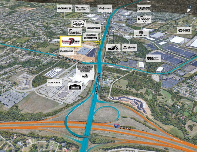
NEARBY LISTINGS FOR SALE OR LEASE
Property Detail
Maple Spring Dr
008500960000
.24 ACRES PRESTON STREET RD
Commercialacreage
Jefferson
X
Kentucky
21029C0060G
0.30 AC
2024
South Central
2024
Louisville
001000
Louisville-Jefferson County, KY-IN
DEMOGRAPHICS near Maple Spring Dr
1 Mile
3 Mile
5 Mile
2024 Total Population
7,962
61,824
122,986
2029 Population
7,847
62,285
123,296
Pop Growth 2024-2029
(1.44%)
+ 0.75%
+ 0.25%
Average Age
38
40
40
2024 Total Households
3,181
23,957
48,355
HH Growth 2024-2029
(1.45%)
+ 0.66%
+ 0.15%
Median Household Inc
$69,580
$64,871
$61,628
Avg Household Size
2.50
2.50
2.50
2024 Avg HH Vehicles
2.00
2.00
2.00
Median Home Value
$184,090
$169,334
$181,218
Median Year Built
1986
1979
1977
Nearby Places
Map Layers
Map Styles
 Street
 Aerial
- Restaurants
- Banks
- Shops
- Fitness
- Groceries
PUBLIC TRANSPORTATION
AIRPORT
Louisville Muhammad Ali International
DRIVE
WALK
Distance
Louisville Muhammad Ali International
16 min
8.5 mi
Freight Ports
Port of Toledo
DRIVE
WALK
Distance
Port of Toledo
365 min
312.7 mi
SALE & LEASE HISTORY
LISTING DATE
SALE/LEASE

Jun 26, 2024
For Sale
Nearby Properties
Address
Land Use
TOTAL SIZE
Lot Size
Zoning
Address
Land Use
TOTAL SIZE
Lot Size
Zoning
109.84 AC
R5-RESIDEN
Address
Land Use
TOTAL SIZE
Lot Size
Zoning
21.73 AC
Address
Land Use
TOTAL SIZE
Lot Size
Zoning
15 AC
C2-COMMERC
Address
Land Use
TOTAL SIZE
Lot Size
Zoning
Address
Land Use
TOTAL SIZE
Lot Size
Zoning
39.61 AC
Address
Land Use
TOTAL SIZE
Lot Size
Zoning
407,840 SF
25.51 AC
C2-COMMERC
Address
Land Use
TOTAL SIZE
Lot Size
Zoning
35 AC
C2-COMMERC
Address
Land Use
TOTAL SIZE
Lot Size
Zoning
13.68 AC
Address
Land Use
TOTAL SIZE
Lot Size
Zoning
500,000 SF
33.27 AC
PEC-PLANNE
Address
Land Use
TOTAL SIZE
Lot Size
Zoning
1,411 SF
7.65 AC
OR1-OFFICE
Address
Land Use
TOTAL SIZE
Lot Size
Zoning
2,767 SF
14.38 AC
R7-RESIDEN
Address
Land Use
TOTAL SIZE
Lot Size
Zoning
500,000 SF
27.89 AC
Address
Land Use
TOTAL SIZE
Lot Size
Zoning
9.44 AC
R5-RESIDEN
Address
Land Use
TOTAL SIZE
Lot Size
Zoning
402,560 SF
23.70 AC
PEC-PLANNE
Address
Land Use
TOTAL SIZE
Lot Size
Zoning
23.20 AC
EZ1-ENTERP
Address
Land Use
TOTAL SIZE
Lot Size
Zoning
396,422 SF
23.30 AC
PEC-PLANNE
Address
Land Use
TOTAL SIZE
Lot Size
Zoning
22,076 SF
9.49 AC
R6-RESIDEN
Address
Land Use
TOTAL SIZE
Lot Size
Zoning
16,372 SF
9.75 AC
CN-NEIGHBO
Address
Land Use
TOTAL SIZE
Lot Size
Zoning
Address
Land Use
TOTAL SIZE
Lot Size
Zoning
Address
Land Use
TOTAL SIZE
Lot Size
Zoning
Address
Land Use
TOTAL SIZE
Lot Size
Zoning
12,972 SF
28.36 AC
R6-RESIDEN
Address
Land Use
TOTAL SIZE
Lot Size
Zoning
300,000 SF
19.31 AC
PEC-PLANNE
Address
Land Use
TOTAL SIZE
Lot Size
Zoning
297,024 SF
14.08 AC
Address
Land Use
TOTAL SIZE
Lot Size
Zoning
Address
Land Use
TOTAL SIZE
Lot Size
Zoning
Address
Land Use
TOTAL SIZE
Lot Size
Zoning
4,128 SF
13.33 AC
OR3-OFFICE
Address
Land Use
TOTAL SIZE
Lot Size
Zoning
112,651 SF
9.81 AC
C2-COMMERC
Address
Land Use
TOTAL SIZE
Lot Size
Zoning
203,421 SF
23 AC
C2-COMMERC
Address
Land Use
TOTAL SIZE
Lot Size
Zoning
249,600 SF
15.62 AC
PEC-PLANNE
The World's #1 Commercial Real Estate Marketplace
Connect with us
© 2025 CoStar Group
The information above has been obtained from sources believed reliable. While we do not doubt its accuracy we have not verified it and make no guarantee, warranty or representation about it. It is your responsibility to independently confirm its accuracy and completeness. Any projections, opinions, assumptions, or estimates used are for example only and do not represent the current or future performance of the property. The value of this transaction to you depends on tax and other factors which should be evaluated by your tax, financial, and legal advisors. You and your advisors should conduct a careful, independent investigation of the property to determine to your satisfaction the suitability of the property for your needs.