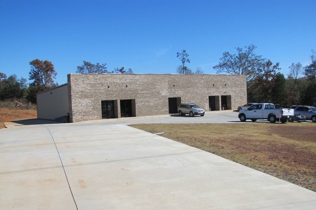
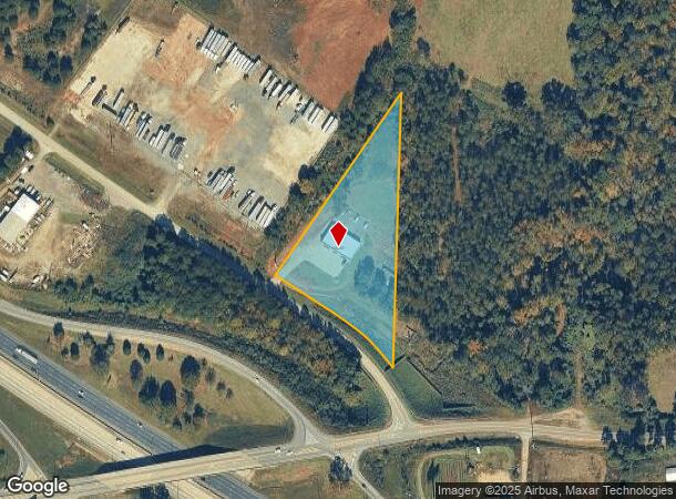
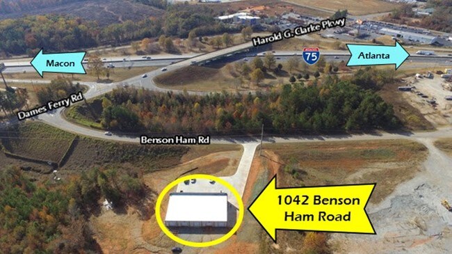
Property Record
1042 Benson Ham Rd, Forsyth, GA 31029
NEARBY LISTINGS FOR SALE OR LEASE
Property Detail
1042 Benson Ham Rd
053-029H
Southeast Monroe County
Officebuilding
LL 214,213 LD 6 PARCEL 1-A-2-B
X
Monroe
13207C0120E
Georgia
2024
4 AC
2025
Monroe County
050102
Atlanta
6,000 SF
Macon-Bibb County, GA
DEMOGRAPHICS near 1042 Benson Ham Rd
1 mile
3 mile
5 mile
2024 Total Population
658
8,204
11,061
2029 Population
744
9,283
12,509
Pop Growth 2024-2029
+ 13.07%
+ 13.15%
+ 13.09%
Average Age
40
40
41
2024 Total Households
248
3,154
4,210
HH Growth 2024-2029
+ 13.71%
+ 13.73%
+ 13.66%
Median Household Inc
$46,923
$56,630
$57,871
Avg Household Size
2.40
2.50
2.50
2024 Avg HH Vehicles
2.00
2.00
2.00
Median Home Value
$240,322
$210,609
$197,660
Median Year Built
1982
1978
1982
Nearby Places
Map Layers
Map Styles
 Street
 Aerial
Transit
 Traffic
 Biking
Places
Listings with unknown addresses are not visible on the map
- Restaurants
- Banks
- Shops
- Fitness
- Groceries
SALE & LEASE HISTORY
LISTING DATE
SALE/LEASE

Dec 27, 2016
For Sale
Dec 27, 2016
For Sale
Nearby Properties
Address
Land Use
TOTAL SIZE
Lot Size
Zoning
Address
Land Use
TOTAL SIZE
Lot Size
Zoning
155,109 SF
23.90 AC
Address
Land Use
TOTAL SIZE
Lot Size
Zoning
1,575 SF
40.87 AC
006
Address
Land Use
TOTAL SIZE
Lot Size
Zoning
37,507 SF
6.17 AC
001
Address
Land Use
TOTAL SIZE
Lot Size
Zoning
53,324 SF
18.14 AC
Address
Land Use
TOTAL SIZE
Lot Size
Zoning
2,871 SF
0.51 AC
001
Address
Land Use
TOTAL SIZE
Lot Size
Zoning
1,192 SF
7.36 AC
006
Address
Land Use
TOTAL SIZE
Lot Size
Zoning
53,324 SF
18.14 AC
Address
Land Use
TOTAL SIZE
Lot Size
Zoning
0.25 AC
003
Address
Land Use
TOTAL SIZE
Lot Size
Zoning
0.11 AC
007
Address
Land Use
TOTAL SIZE
Lot Size
Zoning
40,452 SF
2 AC
Address
Land Use
TOTAL SIZE
Lot Size
Zoning
47,072 SF
2.81 AC
003
Address
Land Use
TOTAL SIZE
Lot Size
Zoning
25,753 SF
5.14 AC
003
Address
Land Use
TOTAL SIZE
Lot Size
Zoning
55,261 SF
17.91 AC
006
Address
Land Use
TOTAL SIZE
Lot Size
Zoning
0.16 AC
003
Address
Land Use
TOTAL SIZE
Lot Size
Zoning
23,360 SF
5.75 AC
003
Address
Land Use
TOTAL SIZE
Lot Size
Zoning
12,960 SF
2.70 AC
001
Address
Land Use
TOTAL SIZE
Lot Size
Zoning
40,280 SF
3.08 AC
001
Address
Land Use
TOTAL SIZE
Lot Size
Zoning
39,132 SF
0.91 AC
Address
Land Use
TOTAL SIZE
Lot Size
Zoning
2,464 SF
10.70 AC
006
Address
Land Use
TOTAL SIZE
Lot Size
Zoning
3.02 AC
006
Address
Land Use
TOTAL SIZE
Lot Size
Zoning
50,820 SF
2.43 AC
006
Address
Land Use
TOTAL SIZE
Lot Size
Zoning
2,568 SF
10.14 AC
003
Address
Land Use
TOTAL SIZE
Lot Size
Zoning
55.20 AC
Address
Land Use
TOTAL SIZE
Lot Size
Zoning
719 SF
3.52 AC
001
Address
Land Use
TOTAL SIZE
Lot Size
Zoning
20,000 SF
9.50 AC
006
Address
Land Use
TOTAL SIZE
Lot Size
Zoning
15,628 SF
5.56 AC
001
Address
Land Use
TOTAL SIZE
Lot Size
Zoning
32,406 SF
7.64 AC
001
Address
Land Use
TOTAL SIZE
Lot Size
Zoning
76.10 AC
Address
Land Use
TOTAL SIZE
Lot Size
Zoning
0.53 AC
003
Address
Land Use
TOTAL SIZE
Lot Size
Zoning
25,208 SF
2.08 AC
The World's #1 Commercial Real Estate Marketplace
Connect with us
© 2026 CoStar Group
The information above has been obtained from sources believed reliable. While we do not doubt its accuracy we have not verified it and make no guarantee, warranty or representation about it. It is your responsibility to independently confirm its accuracy and completeness. Any projections, opinions, assumptions, or estimates used are for example only and do not represent the current or future performance of the property. The value of this transaction to you depends on tax and other factors which should be evaluated by your tax, financial, and legal advisors. You and your advisors should conduct a careful, independent investigation of the property to determine to your satisfaction the suitability of the property for your needs.