Property Record
1042 N Crystal Ave, Benton Harbor, MI 49022


Current Lease Availabilities
NEARBY LISTINGS FOR SALE OR LEASE
Property Detail
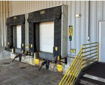
1042 N Crystal Ave
11-03-0009-0020-06-3
COM 607.29' N0DEG43'W OF SW COR SEC 9 T4S R18W TH N0DEG43'W 605' TH N89DEG44'22''E 655.91' TH S0DEG40'28''E 835' TH N70DEG58'13''W 696.21' TO POB SEE 11-54-0009-0020-08-2 & 11-54-0009-0020-09-1 FOR CONTRACT ANNEXATION BETWEEN THE CITY OF BENTON HARBO
Industrialgeneral
Berrien
X
Michigan
26021C0018D
10.84 AC
0
Michigan Southwest Area
2025
Other Market Areas
002300
Niles-Benton Harbor, MI
DEMOGRAPHICS near 1042 N Crystal Ave
1 Mile
3 Mile
5 Mile
2024 Total Population
1,807
18,033
35,712
2029 Population
1,792
18,027
35,365
Pop Growth 2024-2029
(0.83%)
(0.03%)
(0.97%)
Average Age
35
36
39
2024 Total Households
655
6,778
14,843
HH Growth 2024-2029
(1.07%)
(0.32%)
(1.31%)
Median Household Inc
$31,264
$28,080
$39,052
Avg Household Size
2.50
2.50
2.30
2024 Avg HH Vehicles
1.00
1.00
2.00
Median Home Value
$81,455
$108,363
$165,126
Median Year Built
1964
1964
1959
Nearby Places
Map Layers
Map Styles
 Street
 Aerial
- Restaurants
- Banks
- Shops
- Fitness
- Groceries
PUBLIC TRANSPORTATION
COMMUTER RAIL
St. Joseph-Benton Harbor Amtrak Station (Pere Marquette - Amtrak)
DRIVE
WALK
Distance
St. Joseph-Benton Harbor Amtrak Station (Pere Marquette - Amtrak)
12 min
5.5 mi
AIRPORT
South Bend International
DRIVE
WALK
Distance
South Bend International
53 min
36.8 mi
Freight Ports
Port Milwaukee
DRIVE
WALK
Distance
Port Milwaukee
226 min
187.1 mi
Nearby Properties
Address
Land Use
TOTAL SIZE
Lot Size
Zoning
Address
Land Use
TOTAL SIZE
Lot Size
Zoning
365,903 SF
95.25 AC
Address
Land Use
TOTAL SIZE
Lot Size
Zoning
99,468 SF
10.07 AC
DISTRICT G
Address
Land Use
TOTAL SIZE
Lot Size
Zoning
86,000 SF
22.38 AC
D1 COMM
Address
Land Use
TOTAL SIZE
Lot Size
Zoning
75,050 SF
5.33 AC
NONE
Address
Land Use
TOTAL SIZE
Lot Size
Zoning
108,300 SF
12.36 AC
DISTRICT F
Address
Land Use
TOTAL SIZE
Lot Size
Zoning
40,063 SF
9.78 AC
DISTRICT G
Address
Land Use
TOTAL SIZE
Lot Size
Zoning
70,617 SF
12 AC
E RESTRICT
Address
Land Use
TOTAL SIZE
Lot Size
Zoning
151,462 SF
9.96 AC
DISTRICT F
Address
Land Use
TOTAL SIZE
Lot Size
Zoning
71,755 SF
11.06 AC
Address
Land Use
TOTAL SIZE
Lot Size
Zoning
142,200 SF
18 AC
DISTRICT G
Address
Land Use
TOTAL SIZE
Lot Size
Zoning
48,756 SF
3.33 AC
DISTRICT A
Address
Land Use
TOTAL SIZE
Lot Size
Zoning
34,384 SF
2.76 AC
DISTRICT D
Address
Land Use
TOTAL SIZE
Lot Size
Zoning
21,600 SF
Address
Land Use
TOTAL SIZE
Lot Size
Zoning
70,321 SF
14.71 AC
C MULTI
Address
Land Use
TOTAL SIZE
Lot Size
Zoning
1,590 SF
33.32 AC
C MULTI
Address
Land Use
TOTAL SIZE
Lot Size
Zoning
174,061 SF
17.95 AC
DISTRICT G
Address
Land Use
TOTAL SIZE
Lot Size
Zoning
24,800 SF
0.29 AC
DISTRICT E
Address
Land Use
TOTAL SIZE
Lot Size
Zoning
24,280 SF
DISTRICT A
Address
Land Use
TOTAL SIZE
Lot Size
Zoning
112,288 SF
12.31 AC
DISTRICT G
Address
Land Use
TOTAL SIZE
Lot Size
Zoning
Address
Land Use
TOTAL SIZE
Lot Size
Zoning
9,276 SF
1.48 AC
D1 COMM
Address
Land Use
TOTAL SIZE
Lot Size
Zoning
13,500 SF
3.54 AC
E RESTRICT
Address
Land Use
TOTAL SIZE
Lot Size
Zoning
58,903 SF
DISTRICT A
Address
Land Use
TOTAL SIZE
Lot Size
Zoning
23,030 SF
0.13 AC
DISTRICT E
Address
Land Use
TOTAL SIZE
Lot Size
Zoning
62,528 SF
0.23 AC
DISTRICT A
Address
Land Use
TOTAL SIZE
Lot Size
Zoning
38,648 SF
0.15 AC
DISTRICT E
Address
Land Use
TOTAL SIZE
Lot Size
Zoning
16 AC
F HEAVY
Address
Land Use
TOTAL SIZE
Lot Size
Zoning
16,432 SF
44.73 AC
DISTRICT A
Address
Land Use
TOTAL SIZE
Lot Size
Zoning
48,267 SF
10.49 AC
DISTRICT G
Address
Land Use
TOTAL SIZE
Lot Size
Zoning
0.15 AC
DISTRICT B
The World's #1 Commercial Real Estate Marketplace
Connect with us
© 2026 CoStar Group
The information above has been obtained from sources believed reliable. While we do not doubt its accuracy we have not verified it and make no guarantee, warranty or representation about it. It is your responsibility to independently confirm its accuracy and completeness. Any projections, opinions, assumptions, or estimates used are for example only and do not represent the current or future performance of the property. The value of this transaction to you depends on tax and other factors which should be evaluated by your tax, financial, and legal advisors. You and your advisors should conduct a careful, independent investigation of the property to determine to your satisfaction the suitability of the property for your needs.