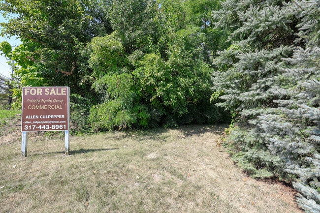
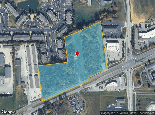
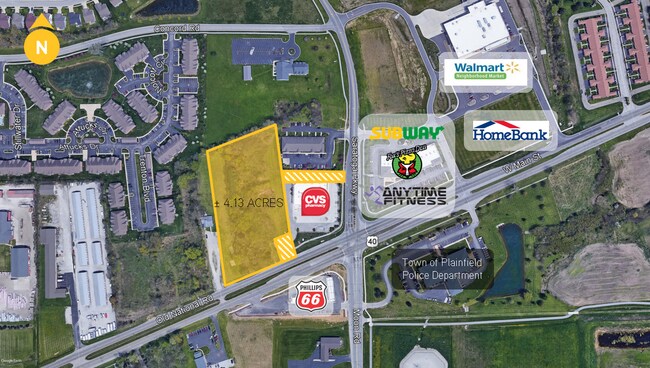
Property Record
1042 W Main St, Plainfield, IN 46168
NEARBY LISTINGS FOR SALE OR LEASE
Property Detail
1042 W Main St
32-10-33-200-034.000-012
PT SE NE 33-15N-1E 8.913 AC
Commercialacreage
Hendricks
X
Indiana
18109C0025E
8.91 AC
2024
Hendricks County
2024
Indianapolis
210802
Indianapolis-Carmel-Greenwood, IN
DEMOGRAPHICS near 1042 W Main St
1 Mile
3 Mile
5 Mile
2024 Total Population
8,074
37,272
63,981
2029 Population
9,049
41,661
71,556
Pop Growth 2024-2029
+ 12.08%
+ 11.78%
+ 11.84%
Average Age
39
40
40
2024 Total Households
3,100
13,615
23,636
HH Growth 2024-2029
+ 12.23%
+ 11.96%
+ 11.95%
Median Household Inc
$90,215
$82,218
$88,421
Avg Household Size
2.60
2.50
2.50
2024 Avg HH Vehicles
2.00
2.00
2.00
Median Home Value
$249,912
$246,194
$249,664
Median Year Built
2004
1993
1995
Nearby Places
Map Layers
Map Styles
 Street
 Aerial
- Restaurants
- Banks
- Shops
- Fitness
- Groceries
PUBLIC TRANSPORTATION
AIRPORT
Indianapolis International
DRIVE
WALK
Distance
Indianapolis International
20 min
8.7 mi
Freight Ports
Port of Toledo
DRIVE
WALK
Distance
Port of Toledo
296 min
240.6 mi
SALE & LEASE HISTORY
LISTING DATE
SALE/LEASE

Feb 12, 2018
For Sale
Aug 17, 2020
For Sale
Nearby Properties
Address
Land Use
TOTAL SIZE
Lot Size
Zoning
Address
Land Use
TOTAL SIZE
Lot Size
Zoning
518,536 SF
25.66 AC
Address
Land Use
TOTAL SIZE
Lot Size
Zoning
3,443 SF
15.82 AC
Address
Land Use
TOTAL SIZE
Lot Size
Zoning
357,000 SF
27.34 AC
Address
Land Use
TOTAL SIZE
Lot Size
Zoning
Address
Land Use
TOTAL SIZE
Lot Size
Zoning
4,933 SF
20.70 AC
Address
Land Use
TOTAL SIZE
Lot Size
Zoning
2.31 AC
Address
Land Use
TOTAL SIZE
Lot Size
Zoning
2,811 SF
14.97 AC
Address
Land Use
TOTAL SIZE
Lot Size
Zoning
354,573 SF
70.34 AC
Address
Land Use
TOTAL SIZE
Lot Size
Zoning
16,224 SF
14.08 AC
Address
Land Use
TOTAL SIZE
Lot Size
Zoning
81,910 SF
10.62 AC
Address
Land Use
TOTAL SIZE
Lot Size
Zoning
146,051 SF
13.77 AC
Address
Land Use
TOTAL SIZE
Lot Size
Zoning
192,212 SF
30.87 AC
Address
Land Use
TOTAL SIZE
Lot Size
Zoning
220,371 SF
22.56 AC
Address
Land Use
TOTAL SIZE
Lot Size
Zoning
67,502 SF
5.06 AC
Address
Land Use
TOTAL SIZE
Lot Size
Zoning
96,288 SF
0.84 AC
Address
Land Use
TOTAL SIZE
Lot Size
Zoning
79,540 SF
12.93 AC
Address
Land Use
TOTAL SIZE
Lot Size
Zoning
10,953 SF
4.37 AC
Address
Land Use
TOTAL SIZE
Lot Size
Zoning
11,538 SF
14.30 AC
Address
Land Use
TOTAL SIZE
Lot Size
Zoning
49,984 SF
5.59 AC
Address
Land Use
TOTAL SIZE
Lot Size
Zoning
2,640 SF
8.70 AC
Address
Land Use
TOTAL SIZE
Lot Size
Zoning
57,602 SF
5.96 AC
Address
Land Use
TOTAL SIZE
Lot Size
Zoning
17,688 SF
1.05 AC
Address
Land Use
TOTAL SIZE
Lot Size
Zoning
29,629 SF
2 AC
Address
Land Use
TOTAL SIZE
Lot Size
Zoning
41,092 SF
7.33 AC
Address
Land Use
TOTAL SIZE
Lot Size
Zoning
14,544 SF
2.39 AC
Address
Land Use
TOTAL SIZE
Lot Size
Zoning
24,144 SF
2.06 AC
Address
Land Use
TOTAL SIZE
Lot Size
Zoning
61,404 SF
6 AC
Address
Land Use
TOTAL SIZE
Lot Size
Zoning
8,800 SF
6.15 AC
Address
Land Use
TOTAL SIZE
Lot Size
Zoning
51,034 SF
4.41 AC
Address
Land Use
TOTAL SIZE
Lot Size
Zoning
21,544 SF
2.69 AC
The World's #1 Commercial Real Estate Marketplace
Connect with us
© 2026 CoStar Group
The information above has been obtained from sources believed reliable. While we do not doubt its accuracy we have not verified it and make no guarantee, warranty or representation about it. It is your responsibility to independently confirm its accuracy and completeness. Any projections, opinions, assumptions, or estimates used are for example only and do not represent the current or future performance of the property. The value of this transaction to you depends on tax and other factors which should be evaluated by your tax, financial, and legal advisors. You and your advisors should conduct a careful, independent investigation of the property to determine to your satisfaction the suitability of the property for your needs.