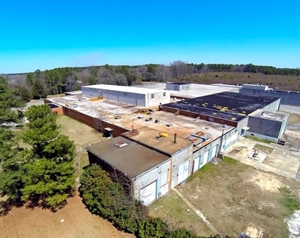
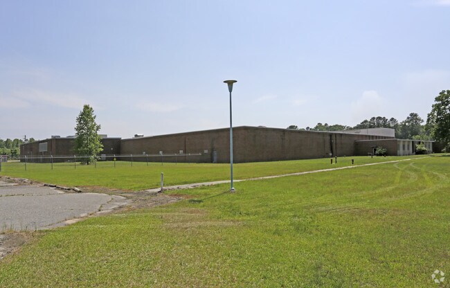
Property Record
10420 Old Wire Rd, Laurel Hill, NC 28351

Property Detail
10420 Old Wire Rd
02-0309-01-003
LAUREL CREST PLANT
Industrialgeneral
SCOTLAND
I2
North Carolina
AE The base floodplain where base flood elevations are provided. AE Zones are now used on new format FIRMs instead of A1-A30 Zones.
45.50 AC
2025
North Carolina Southeast Area
2025
Other Market Areas
010502
Laurinburg, NC
197,535 SF
NEARBY LISTINGS FOR SALE OR LEASE
DEMOGRAPHICS near 10420 Old Wire Rd
1 mile
3 mile
5 mile
2025 Total Population
457
2,831
10,882
2030 Population
463
2,882
11,048
Pop Growth 2025-2030
+ 1.31%
+ 1.80%
+ 1.53%
Average Age
43
42
41
2025 Total Households
178
1,148
4,522
HH Growth 2025-2030
+ 0.56%
+ 1.66%
+ 1.22%
Median Household Inc
$36,750
$49,438
$51,240
Avg Household Size
2.40
2.40
2.40
2025 Avg HH Vehicles
2.00
2.00
2.00
Median Home Value
$81,249
$92,307
$118,827
Median Year Built
1988
1987
1979
Nearby Places
Map Layers
Map Styles
 Street
 Aerial
Layers
 Traffic
 Biking
Places
Listings with unknown addresses are not visible on the map
- Restaurants
- Banks
- Shops
- Fitness
- Groceries
SALE & LEASE HISTORY
LISTING DATE
SALE/LEASE

Sep 24, 2016
For Lease
Sep 23, 2016
For Sale
Nearby Properties
Address
Land Use
TOTAL SIZE
Lot Size
Zoning
Address
Land Use
TOTAL SIZE
Lot Size
Zoning
90,002 SF
45.09 AC
RA
Address
Land Use
TOTAL SIZE
Lot Size
Zoning
220,565 SF
52.48 AC
I
Address
Land Use
TOTAL SIZE
Lot Size
Zoning
77,619 SF
21.91 AC
RA
Address
Land Use
TOTAL SIZE
Lot Size
Zoning
5,223 SF
32.10 AC
I
Address
Land Use
TOTAL SIZE
Lot Size
Zoning
9,450 SF
26.80 AC
I2
Address
Land Use
TOTAL SIZE
Lot Size
Zoning
204,213 SF
21.40 AC
I2
Address
Land Use
TOTAL SIZE
Lot Size
Zoning
9,984 SF
2.23 AC
RA
Address
Land Use
TOTAL SIZE
Lot Size
Zoning
12,168 SF
8.26 AC
R1
Address
Land Use
TOTAL SIZE
Lot Size
Zoning
2,568 SF
0.81 AC
RA
Address
Land Use
TOTAL SIZE
Lot Size
Zoning
8,736 SF
11.88 AC
I1
Address
Land Use
TOTAL SIZE
Lot Size
Zoning
37,730 SF
50.25 AC
I2
Address
Land Use
TOTAL SIZE
Lot Size
Zoning
6,436 SF
2.42 AC
RA
Address
Land Use
TOTAL SIZE
Lot Size
Zoning
1,152 SF
273.29 AC
RA
Address
Land Use
TOTAL SIZE
Lot Size
Zoning
13,080 SF
10 AC
RA
Address
Land Use
TOTAL SIZE
Lot Size
Zoning
3,124 SF
5.80 AC
RA
Address
Land Use
TOTAL SIZE
Lot Size
Zoning
8,980 SF
2.07 AC
HC
Address
Land Use
TOTAL SIZE
Lot Size
Zoning
7,763 SF
8.77 AC
RA
Address
Land Use
TOTAL SIZE
Lot Size
Zoning
2,264 SF
10 AC
HC
Address
Land Use
TOTAL SIZE
Lot Size
Zoning
4,620 SF
2.34 AC
RA
Address
Land Use
TOTAL SIZE
Lot Size
Zoning
3,324 SF
2 AC
RA
Address
Land Use
TOTAL SIZE
Lot Size
Zoning
87 AC
I2
Address
Land Use
TOTAL SIZE
Lot Size
Zoning
1,896 SF
2.06 AC
RA
Address
Land Use
TOTAL SIZE
Lot Size
Zoning
2,734 SF
2.50 AC
HC
Address
Land Use
TOTAL SIZE
Lot Size
Zoning
255.40 AC
RA
Address
Land Use
TOTAL SIZE
Lot Size
Zoning
720.60 AC
RA
Address
Land Use
TOTAL SIZE
Lot Size
Zoning
20.01 AC
Address
Land Use
TOTAL SIZE
Lot Size
Zoning
4,032 SF
0.25 AC
RA
Address
Land Use
TOTAL SIZE
Lot Size
Zoning
5,968 SF
3.53 AC
RA
Address
Land Use
TOTAL SIZE
Lot Size
Zoning
4,000 SF
2.06 AC
I1
The World's #1 Commercial Real Estate Marketplace
Connect with us
© 2026 CoStar Group
The information above has been obtained from sources believed reliable. While we do not doubt its accuracy we have not verified it and make no guarantee, warranty or representation about it. It is your responsibility to independently confirm its accuracy and completeness. Any projections, opinions, assumptions, or estimates used are for example only and do not represent the current or future performance of the property. The value of this transaction to you depends on tax and other factors which should be evaluated by your tax, financial, and legal advisors. You and your advisors should conduct a careful, independent investigation of the property to determine to your satisfaction the suitability of the property for your needs.