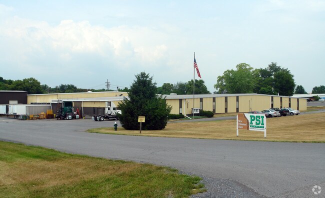
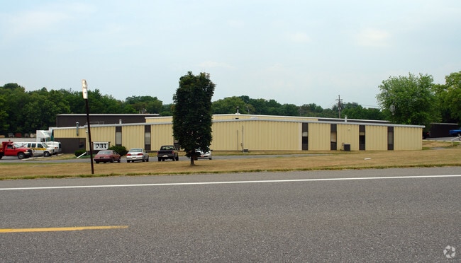
Property Record
10422 Governor Lane Blvd, Williamsport, MD 21795

NEARBY LISTINGS FOR SALE OR LEASE
Property Detail
10422 Governor Lane Blvd
02-010658
7.564 ACRES 10422 GOVERNOR LANE BLVD
Warehouse
Washington
X
Maryland
24043C0281D
7.56 AC
2024
Washington County
2025
Washington, DC
010802
Hagerstown-Martinsburg, MD-WV
20,000 SF
DEMOGRAPHICS near 10422 Governor Lane Blvd
1 Mile
3 Mile
5 Mile
2024 Total Population
4,463
16,788
50,527
2029 Population
4,534
17,212
52,192
Pop Growth 2024-2029
+ 1.59%
+ 2.53%
+ 3.30%
Average Age
45
43
41
2024 Total Households
1,869
6,753
19,723
HH Growth 2024-2029
+ 1.77%
+ 2.72%
+ 3.35%
Median Household Inc
$66,755
$66,828
$64,456
Avg Household Size
2.20
2.40
2.50
2024 Avg HH Vehicles
2.00
2.00
2.00
Median Home Value
$250,295
$222,141
$210,825
Median Year Built
1971
1973
1976
Nearby Places
Map Layers
Map Styles
 Street
 Aerial
- Restaurants
- Banks
- Shops
- Fitness
- Groceries
PUBLIC TRANSPORTATION
AIRPORT
Hagerstown Regional/Richard A Henson Field
DRIVE
WALK
Distance
Hagerstown Regional/Richard A Henson Field
15 min
9.7 mi
Nearby Properties
Address
Land Use
TOTAL SIZE
Lot Size
Zoning
Address
Land Use
TOTAL SIZE
Lot Size
Zoning
1,234,240 SF
134.80 AC
HI
Address
Land Use
TOTAL SIZE
Lot Size
Zoning
825,620 SF
53.74 AC
IG
Address
Land Use
TOTAL SIZE
Lot Size
Zoning
737,000 SF
59.57 AC
PB
Address
Land Use
TOTAL SIZE
Lot Size
Zoning
157,680 SF
69.83 AC
HI
Address
Land Use
TOTAL SIZE
Lot Size
Zoning
591,555 SF
114.50 AC
HI
Address
Land Use
TOTAL SIZE
Lot Size
Zoning
153,846 SF
110.85 AC
U
Address
Land Use
TOTAL SIZE
Lot Size
Zoning
1,021,162 SF
117.63 AC
HI
Address
Land Use
TOTAL SIZE
Lot Size
Zoning
824,298 SF
70.25 AC
HI
Address
Land Use
TOTAL SIZE
Lot Size
Zoning
162,850 SF
65.81 AC
IG
Address
Land Use
TOTAL SIZE
Lot Size
Zoning
294,240 SF
43.79 AC
HI
Address
Land Use
TOTAL SIZE
Lot Size
Zoning
161,172 SF
19.70 AC
HI
Address
Land Use
TOTAL SIZE
Lot Size
Zoning
506,003 SF
40 AC
HI
Address
Land Use
TOTAL SIZE
Lot Size
Zoning
91,026 SF
20.28 AC
A
Address
Land Use
TOTAL SIZE
Lot Size
Zoning
486,861 SF
35.40 AC
HI
Address
Land Use
TOTAL SIZE
Lot Size
Zoning
231,293 SF
16.93 AC
PI
Address
Land Use
TOTAL SIZE
Lot Size
Zoning
88,042 SF
9.98 AC
RT
Address
Land Use
TOTAL SIZE
Lot Size
Zoning
39,578 SF
64.90 AC
ORI
Address
Land Use
TOTAL SIZE
Lot Size
Zoning
36,000 SF
23.49 AC
HI
Address
Land Use
TOTAL SIZE
Lot Size
Zoning
9,918 SF
17 AC
IG
Address
Land Use
TOTAL SIZE
Lot Size
Zoning
5,427 SF
20.49 AC
BG
Address
Land Use
TOTAL SIZE
Lot Size
Zoning
2,324 SF
6 AC
TR
Address
Land Use
TOTAL SIZE
Lot Size
Zoning
924 SF
67.86 AC
RU
Address
Land Use
TOTAL SIZE
Lot Size
Zoning
58,065 SF
15.42 AC
BG
Address
Land Use
TOTAL SIZE
Lot Size
Zoning
16,102 SF
14 AC
ORI
Address
Land Use
TOTAL SIZE
Lot Size
Zoning
7,943 SF
26.33 AC
HI
Address
Land Use
TOTAL SIZE
Lot Size
Zoning
2,723 SF
89.57 AC
RB-E
Address
Land Use
TOTAL SIZE
Lot Size
Zoning
110,387 SF
10.51 AC
PB
Address
Land Use
TOTAL SIZE
Lot Size
Zoning
110,000 SF
27.85 AC
IG
Address
Land Use
TOTAL SIZE
Lot Size
Zoning
136,874 SF
17.48 AC
CR
Address
Land Use
TOTAL SIZE
Lot Size
Zoning
32,788 SF
22.20 AC
PI
The World's #1 Commercial Real Estate Marketplace
Connect with us
© 2026 CoStar Group
The information above has been obtained from sources believed reliable. While we do not doubt its accuracy we have not verified it and make no guarantee, warranty or representation about it. It is your responsibility to independently confirm its accuracy and completeness. Any projections, opinions, assumptions, or estimates used are for example only and do not represent the current or future performance of the property. The value of this transaction to you depends on tax and other factors which should be evaluated by your tax, financial, and legal advisors. You and your advisors should conduct a careful, independent investigation of the property to determine to your satisfaction the suitability of the property for your needs.