Property Record
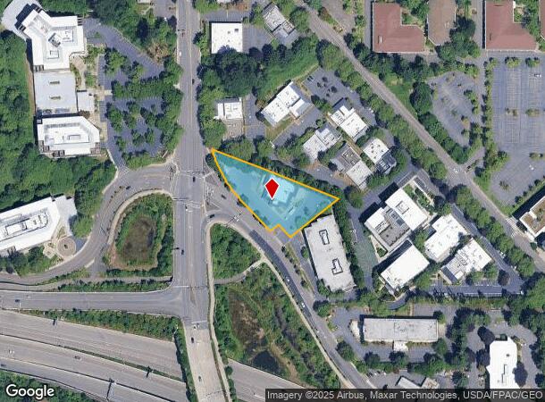
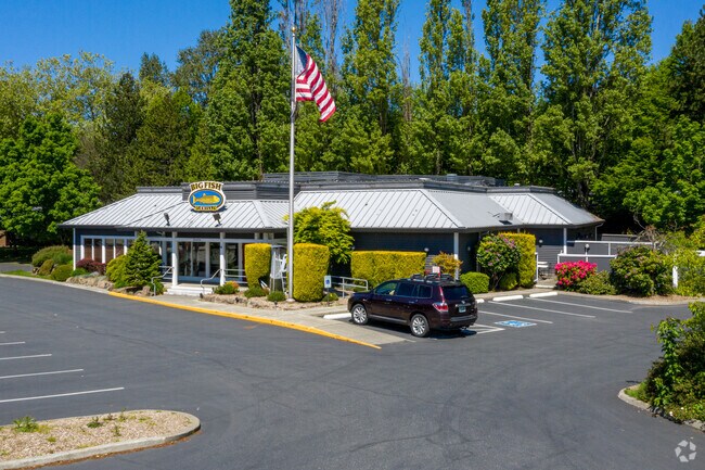
10426 Northup Way, Kirkland, WA 98033


NEARBY LISTINGS FOR SALE OR LEASE
Property Detail
10426 Northup Way
Seattle-Tacoma-Bellevue, WA
Sp 77-11-1 El
202505-9055
LOT A KIRKLAND SP 77-11-1 (EL) REC AF #7712010846 SD SP DAF - THAT POR OF NE 1/4 OF NW 1/4 OF 20-25-05 STR DAF - BEG IRON PIPE WCH IS S 968.77 FT &W 879.49 FT FR N 1/4 COR OF SD SEC TH N 69-44-45 W TO ELY MGN OF RD TH SELY ALG SD ELY MGN TO S LN OF S
Restaurantbuilding
King
X
Washington
53033C0365G
a
2025
0.91 AC
2024
520 Corridor
022701
Seattle/Puget Sound
6,518 SF
DEMOGRAPHICS near 10426 Northup Way
1 Mile
3 Mile
5 Mile
2024 Total Population
10,127
96,780
294,068
2029 Population
10,220
98,715
298,635
Pop Growth 2024-2029
+ 0.92%
+ 2.00%
+ 1.55%
Average Age
39
39
39
2024 Total Households
3,902
43,500
124,342
HH Growth 2024-2029
+ 0.82%
+ 2.06%
+ 1.62%
Median Household Inc
$195,637
$159,135
$149,042
Avg Household Size
2.50
2.20
2.30
2024 Avg HH Vehicles
2.00
2.00
2.00
Median Home Value
$1,127,191
$1,095,804
$1,053,942
Median Year Built
1982
1990
1983
Nearby Places
Map Layers
Map Styles
 Street
 Aerial
- Restaurants
- Banks
- Shops
- Fitness
- Groceries
PUBLIC TRANSPORTATION
COMMUTER RAIL
King Street (Seattle) Station (Sounder South Line - Central Puget Sound Regional Transit Authority Rail (Link Light Rail/Sounder))
DRIVE
WALK
Distance
King Street (Seattle) Station (Sounder South Line - Central Puget Sound Regional Transit Authority Rail (Link Light Rail/Sounder))
15 min
9.5 mi
AIRPORT
Seattle-Tacoma International
DRIVE
WALK
Distance
Seattle-Tacoma International
30 min
19.3 mi
Seattle Paine Field International
DRIVE
WALK
Distance
Seattle Paine Field International
34 min
22.1 mi
SALE & LEASE HISTORY
LISTING DATE
SALE/LEASE

Jun 09, 2020
For Lease
Nearby Properties
Address
Land Use
TOTAL SIZE
Lot Size
Zoning
Address
Land Use
TOTAL SIZE
Lot Size
Zoning
6,575 SF
2.03 AC
DNTNO-1
Address
Land Use
TOTAL SIZE
Lot Size
Zoning
629,600 SF
2.62 AC
DNTN-MU
Address
Land Use
TOTAL SIZE
Lot Size
Zoning
218,371 SF
16.41 AC
DNTN-MU
Address
Land Use
TOTAL SIZE
Lot Size
Zoning
521,058 SF
2.46 AC
DT-O-2-S
Address
Land Use
TOTAL SIZE
Lot Size
Zoning
5,500 SF
1.77 AC
DT-O-2-N
Address
Land Use
TOTAL SIZE
Lot Size
Zoning
397,428 SF
2.48 AC
DT-O-2-N
Address
Land Use
TOTAL SIZE
Lot Size
Zoning
786,424 SF
1.54 AC
DT-O-2-N
Address
Land Use
TOTAL SIZE
Lot Size
Zoning
574,970 SF
1.72 AC
DNTNO-1
Address
Land Use
TOTAL SIZE
Lot Size
Zoning
781,977 SF
1.32 AC
DT-O-2-S
Address
Land Use
TOTAL SIZE
Lot Size
Zoning
723,028 SF
1.73 AC
DNTNO-1
Address
Land Use
TOTAL SIZE
Lot Size
Zoning
331,098 SF
1.50 AC
DNTN-MU
Address
Land Use
TOTAL SIZE
Lot Size
Zoning
538,017 SF
0.91 AC
DNTNO-1
Address
Land Use
TOTAL SIZE
Lot Size
Zoning
105,056 SF
15.92 AC
PLA 15A
Address
Land Use
TOTAL SIZE
Lot Size
Zoning
372,228 SF
1.04 AC
DT-O-2-S
Address
Land Use
TOTAL SIZE
Lot Size
Zoning
134,200 SF
4.04 AC
DT-OLB-N
Address
Land Use
TOTAL SIZE
Lot Size
Zoning
976,392 SF
0.88 AC
DNTNO-1
Address
Land Use
TOTAL SIZE
Lot Size
Zoning
783,546 SF
0.92 AC
DNTNO-1
Address
Land Use
TOTAL SIZE
Lot Size
Zoning
265,300 SF
1.91 AC
DNTN-OB
Address
Land Use
TOTAL SIZE
Lot Size
Zoning
672,713 SF
1.31 AC
DNTNO-1
Address
Land Use
TOTAL SIZE
Lot Size
Zoning
18,398 SF
1.45 AC
DNTNO-1
Address
Land Use
TOTAL SIZE
Lot Size
Zoning
695,328 SF
4.81 AC
DT-O-2-E
Address
Land Use
TOTAL SIZE
Lot Size
Zoning
10,500 SF
2.33 AC
BR-RC-2
Address
Land Use
TOTAL SIZE
Lot Size
Zoning
726,000 SF
1.66 AC
DNTNO-1
Address
Land Use
TOTAL SIZE
Lot Size
Zoning
113,412 SF
10.26 AC
OBAT
Address
Land Use
TOTAL SIZE
Lot Size
Zoning
188,062 SF
0.91 AC
DNTN-MU
Address
Land Use
TOTAL SIZE
Lot Size
Zoning
2.25 AC
DNTNO-1
Address
Land Use
TOTAL SIZE
Lot Size
Zoning
27,900 SF
4.02 AC
DNTNO-1
Address
Land Use
TOTAL SIZE
Lot Size
Zoning
337,096 SF
0.94 AC
DNTN-MU
Address
Land Use
TOTAL SIZE
Lot Size
Zoning
230,239 SF
1.77 AC
DNTN-MU
Address
Land Use
TOTAL SIZE
Lot Size
Zoning
629,094 SF
2.01 AC
DNTN-MU
The World's #1 Commercial Real Estate Marketplace
Connect with us
© 2025 CoStar Group
The information above has been obtained from sources believed reliable. While we do not doubt its accuracy we have not verified it and make no guarantee, warranty or representation about it. It is your responsibility to independently confirm its accuracy and completeness. Any projections, opinions, assumptions, or estimates used are for example only and do not represent the current or future performance of the property. The value of this transaction to you depends on tax and other factors which should be evaluated by your tax, financial, and legal advisors. You and your advisors should conduct a careful, independent investigation of the property to determine to your satisfaction the suitability of the property for your needs.