Property Record
1043 Fish Creek Rd, Estes Park, CO 80517
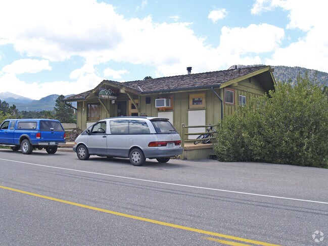

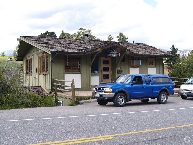
Property Detail
1043 Fish Creek Rd
Fort Collins-Loveland, CO
LOT 1, STONE BRIDGE ESTATES, EP (20080035445)
25311-68-001
Larimer
Officebuilding
Colorado
AE The base floodplain where base flood elevations are provided. AE Zones are now used on new format FIRMs instead of A1-A30 Zones.
1
2024
0.66 AC
2025
Outlying Larimer County
002804
Denver
2,088 SF
NEARBY LISTINGS FOR SALE OR LEASE
DEMOGRAPHICS near 1043 Fish Creek Rd
1 mile
3 mile
5 mile
2024 Total Population
2,481
11,801
13,667
2029 Population
2,653
12,820
14,840
Pop Growth 2024-2029
+ 6.93%
+ 8.63%
+ 8.58%
Average Age
48
50
50
2024 Total Households
1,159
5,390
6,210
HH Growth 2024-2029
+ 7.08%
+ 8.91%
+ 8.87%
Median Household Inc
$70,754
$79,036
$78,259
Avg Household Size
2.10
2.10
2.10
2024 Avg HH Vehicles
2.00
2.00
2.00
Median Home Value
$746,788
$747,086
$748,720
Median Year Built
1986
1985
1984
Nearby Places
Map Layers
Map Styles
 Street
 Aerial
Transit
 Traffic
 Biking
Places
Listings with unknown addresses are not visible on the map
- Restaurants
- Banks
- Shops
- Fitness
- Groceries
Nearby Properties
Address
Land Use
TOTAL SIZE
Lot Size
Zoning
Address
Land Use
TOTAL SIZE
Lot Size
Zoning
146,778 SF
34.35 AC
Address
Land Use
TOTAL SIZE
Lot Size
Zoning
142,497 SF
13.91 AC
Address
Land Use
TOTAL SIZE
Lot Size
Zoning
38,222 SF
3.53 AC
Address
Land Use
TOTAL SIZE
Lot Size
Zoning
45,000 SF
6.88 AC
Address
Land Use
TOTAL SIZE
Lot Size
Zoning
99,837 SF
3.91 AC
Address
Land Use
TOTAL SIZE
Lot Size
Zoning
54,061 SF
5.55 AC
Address
Land Use
TOTAL SIZE
Lot Size
Zoning
88,668 SF
4.16 AC
Address
Land Use
TOTAL SIZE
Lot Size
Zoning
45,229 SF
3.80 AC
Address
Land Use
TOTAL SIZE
Lot Size
Zoning
55,690 SF
5 AC
Address
Land Use
TOTAL SIZE
Lot Size
Zoning
44,531 SF
3.33 AC
Address
Land Use
TOTAL SIZE
Lot Size
Zoning
51,044 SF
3.26 AC
Address
Land Use
TOTAL SIZE
Lot Size
Zoning
76,952 SF
1.95 AC
Address
Land Use
TOTAL SIZE
Lot Size
Zoning
17,933 SF
2.58 AC
Address
Land Use
TOTAL SIZE
Lot Size
Zoning
21,352 SF
4.56 AC
Address
Land Use
TOTAL SIZE
Lot Size
Zoning
24,983 SF
1.61 AC
Address
Land Use
TOTAL SIZE
Lot Size
Zoning
22,800 SF
10.50 AC
Address
Land Use
TOTAL SIZE
Lot Size
Zoning
23,803 SF
4.02 AC
Address
Land Use
TOTAL SIZE
Lot Size
Zoning
20,112 SF
1.89 AC
Address
Land Use
TOTAL SIZE
Lot Size
Zoning
27,198 SF
6 AC
RE
Address
Land Use
TOTAL SIZE
Lot Size
Zoning
43,004 SF
4.19 AC
Address
Land Use
TOTAL SIZE
Lot Size
Zoning
61,320 SF
5.87 AC
Address
Land Use
TOTAL SIZE
Lot Size
Zoning
35,430 SF
39.15 AC
O
Address
Land Use
TOTAL SIZE
Lot Size
Zoning
19,308 SF
1.34 AC
Address
Land Use
TOTAL SIZE
Lot Size
Zoning
17,218 SF
2.47 AC
Address
Land Use
TOTAL SIZE
Lot Size
Zoning
7,495 SF
49 AC
Address
Land Use
TOTAL SIZE
Lot Size
Zoning
29,800 SF
1.55 AC
Address
Land Use
TOTAL SIZE
Lot Size
Zoning
23,362 SF
5.54 AC
Address
Land Use
TOTAL SIZE
Lot Size
Zoning
16,838 SF
1.64 AC
Address
Land Use
TOTAL SIZE
Lot Size
Zoning
5,747 SF
12 AC
A
Address
Land Use
TOTAL SIZE
Lot Size
Zoning
19,015 SF
2.21 AC
The World's #1 Commercial Real Estate Marketplace
Connect with us
© 2026 CoStar Group
The information above has been obtained from sources believed reliable. While we do not doubt its accuracy we have not verified it and make no guarantee, warranty or representation about it. It is your responsibility to independently confirm its accuracy and completeness. Any projections, opinions, assumptions, or estimates used are for example only and do not represent the current or future performance of the property. The value of this transaction to you depends on tax and other factors which should be evaluated by your tax, financial, and legal advisors. You and your advisors should conduct a careful, independent investigation of the property to determine to your satisfaction the suitability of the property for your needs.