Property Record
1043 S State Road 7, Wellington, FL 33414

Current Lease Availabilities
NEARBY LISTINGS FOR SALE OR LEASE
Property Detail
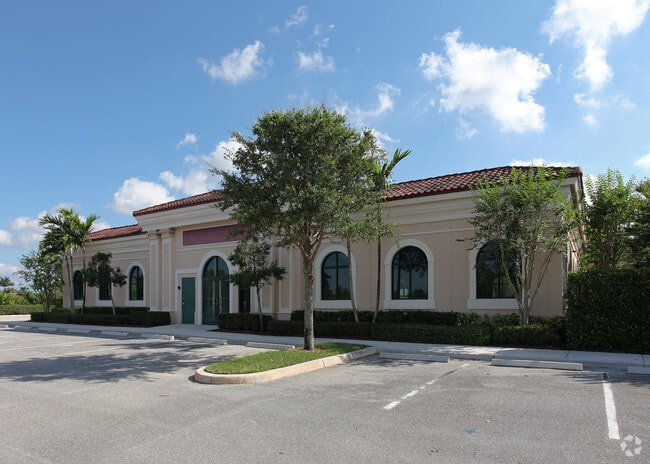
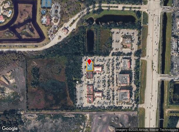
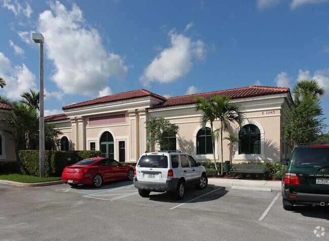
1043 S State Road 7
73-41-44-12-17-005-0000
Wellington Reserve Office Park
Officebuilding
WELLINGTON RESERVE OFFICE PARK TR E K/A DEVELOPMENT
X
Palm Beach
12099C0562F
Florida
2024
0.18 AC
2025
Royal Palm Bch/Wellington
007763
South Florida
5,986 SF
West Palm Beach-Boca Raton-Delray Beach, FL
DEMOGRAPHICS near 1043 S State Road 7
1 Mile
3 Mile
5 Mile
2024 Total Population
9,694
62,210
189,935
2029 Population
9,892
63,715
194,336
Pop Growth 2024-2029
+ 2.04%
+ 2.42%
+ 2.32%
Average Age
37
40
41
2024 Total Households
3,128
21,233
68,401
HH Growth 2024-2029
+ 1.28%
+ 1.81%
+ 1.77%
Median Household Inc
$99,737
$95,368
$75,769
Avg Household Size
3.00
2.80
2.60
2024 Avg HH Vehicles
2.00
2.00
2.00
Median Home Value
$425,752
$420,670
$348,502
Median Year Built
2003
1997
1989
Nearby Places
Map Layers
Map Styles
 Street
 Aerial
- Restaurants
- Banks
- Shops
- Fitness
- Groceries
PUBLIC TRANSPORTATION
AIRPORT
Palm Beach International
DRIVE
WALK
Distance
Palm Beach International
16 min
8.3 mi
Nearby Properties
Address
Land Use
TOTAL SIZE
Lot Size
Zoning
Address
Land Use
TOTAL SIZE
Lot Size
Zoning
590,128 SF
19.55 AC
MUPD
Address
Land Use
TOTAL SIZE
Lot Size
Zoning
398,622 SF
21.62 AC
RM-18
Address
Land Use
TOTAL SIZE
Lot Size
Zoning
536,770 SF
25.06 AC
PUD
Address
Land Use
TOTAL SIZE
Lot Size
Zoning
466,667 SF
36.10 AC
PUD
Address
Land Use
TOTAL SIZE
Lot Size
Zoning
199,032 SF
769.86 AC
PO
Address
Land Use
TOTAL SIZE
Lot Size
Zoning
435,320 SF
13.75 AC
MCPD
Address
Land Use
TOTAL SIZE
Lot Size
Zoning
535,508 SF
19.17 AC
PUD
Address
Land Use
TOTAL SIZE
Lot Size
Zoning
669,818 SF
42.79 AC
IL
Address
Land Use
TOTAL SIZE
Lot Size
Zoning
428,659 SF
26.16 AC
MUPD
Address
Land Use
TOTAL SIZE
Lot Size
Zoning
691,249 SF
33.20 AC
MUPD
Address
Land Use
TOTAL SIZE
Lot Size
Zoning
349,316 SF
49.95 AC
CG
Address
Land Use
TOTAL SIZE
Lot Size
Zoning
377,137 SF
17.64 AC
PUD
Address
Land Use
TOTAL SIZE
Lot Size
Zoning
346,161 SF
17.21 AC
PUD
Address
Land Use
TOTAL SIZE
Lot Size
Zoning
318,687 SF
29.98 AC
RM-9
Address
Land Use
TOTAL SIZE
Lot Size
Zoning
52,656 SF
849.42 AC
PO
Address
Land Use
TOTAL SIZE
Lot Size
Zoning
286,092 SF
11.62 AC
PUD
Address
Land Use
TOTAL SIZE
Lot Size
Zoning
294,321 SF
109.37 AC
PO
Address
Land Use
TOTAL SIZE
Lot Size
Zoning
159,302 SF
29.36 AC
Address
Land Use
TOTAL SIZE
Lot Size
Zoning
338,248 SF
54.21 AC
CF
Address
Land Use
TOTAL SIZE
Lot Size
Zoning
261,118 SF
58.77 AC
IPF
Address
Land Use
TOTAL SIZE
Lot Size
Zoning
106,630 SF
25.01 AC
MUPD
Address
Land Use
TOTAL SIZE
Lot Size
Zoning
180,153 SF
19.22 AC
MUPD
Address
Land Use
TOTAL SIZE
Lot Size
Zoning
113,379 SF
16.56 AC
MUPD
Address
Land Use
TOTAL SIZE
Lot Size
Zoning
185,453 SF
9.63 AC
PUD
Address
Land Use
TOTAL SIZE
Lot Size
Zoning
159,433 SF
38.65 AC
PO
Address
Land Use
TOTAL SIZE
Lot Size
Zoning
116,601 SF
13.94 AC
CG
Address
Land Use
TOTAL SIZE
Lot Size
Zoning
114,960 SF
11.71 AC
PUD
Address
Land Use
TOTAL SIZE
Lot Size
Zoning
68,094 SF
39.77 AC
MUPD
Address
Land Use
TOTAL SIZE
Lot Size
Zoning
94,179 SF
13.01 AC
MUPD
Address
Land Use
TOTAL SIZE
Lot Size
Zoning
149,934 SF
3.47 AC
CG
The World's #1 Commercial Real Estate Marketplace
Connect with us
© 2026 CoStar Group
The information above has been obtained from sources believed reliable. While we do not doubt its accuracy we have not verified it and make no guarantee, warranty or representation about it. It is your responsibility to independently confirm its accuracy and completeness. Any projections, opinions, assumptions, or estimates used are for example only and do not represent the current or future performance of the property. The value of this transaction to you depends on tax and other factors which should be evaluated by your tax, financial, and legal advisors. You and your advisors should conduct a careful, independent investigation of the property to determine to your satisfaction the suitability of the property for your needs.