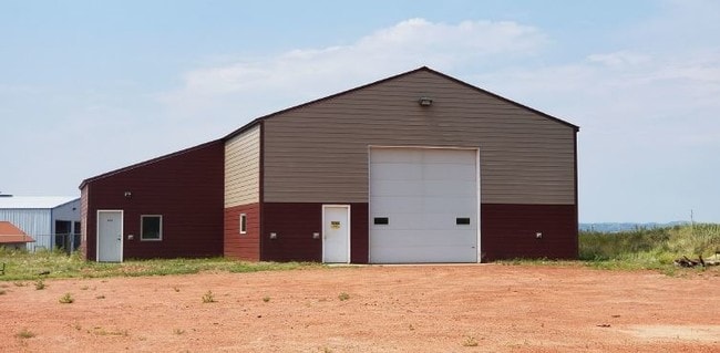
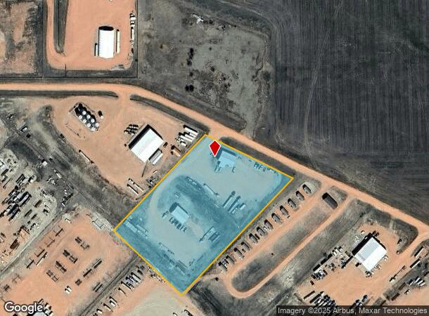
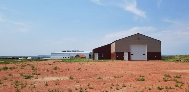
Property Record
10434 1J St Sw, Killdeer, ND 58640
NEARBY LISTINGS FOR SALE OR LEASE
Property Detail
10434 1J St Sw
Dickinson, ND
North Ridge Subdivision
011224127
LOT 10 BLK-003 NORTH RIDGE SUBDIVISION
Commercialnec
Dunn
X
North Dakota
3800260315B
10
2025
4.50 AC
2025
North Dakota Area
962200
Other Market Areas
DEMOGRAPHICS near 10434 1J St Sw
1 mile
3 mile
5 mile
2024 Total Population
31
935
1,104
2029 Population
31
914
1,079
Pop Growth 2024-2029
0.00%
(2.25%)
(2.26%)
Average Age
40
39
39
2024 Total Households
11
336
400
HH Growth 2024-2029
0.00%
(2.38%)
(2.25%)
Median Household Inc
$99,999
$90,937
$91,489
Avg Household Size
2.60
2.70
2.60
2024 Avg HH Vehicles
3.00
3.00
3.00
Median Home Value
$274,999
$290,677
$288,027
Median Year Built
1981
1983
1983
Nearby Places
Map Layers
Map Styles
 Street
 Aerial
Transit
 Traffic
 Biking
Places
Listings with unknown addresses are not visible on the map
- Restaurants
- Banks
- Shops
- Fitness
- Groceries
SALE & LEASE HISTORY
LISTING DATE
SALE/LEASE

Mar 08, 2019
For Sale
Jun 21, 2023
For Sale
Dec 07, 2018
For Lease
Aug 28, 2018
For Sale
Nearby Properties
Address
Land Use
TOTAL SIZE
Lot Size
Zoning
Address
Land Use
TOTAL SIZE
Lot Size
Zoning
Address
Land Use
TOTAL SIZE
Lot Size
Zoning
6.88 AC
Address
Land Use
TOTAL SIZE
Lot Size
Zoning
Address
Land Use
TOTAL SIZE
Lot Size
Zoning
4.81 AC
Address
Land Use
TOTAL SIZE
Lot Size
Zoning
4.03 AC
Address
Land Use
TOTAL SIZE
Lot Size
Zoning
2.99 AC
Address
Land Use
TOTAL SIZE
Lot Size
Zoning
3.60 AC
Address
Land Use
TOTAL SIZE
Lot Size
Zoning
9.92 AC
Address
Land Use
TOTAL SIZE
Lot Size
Zoning
37.10 AC
Address
Land Use
TOTAL SIZE
Lot Size
Zoning
9.91 AC
Address
Land Use
TOTAL SIZE
Lot Size
Zoning
0.40 AC
Address
Land Use
TOTAL SIZE
Lot Size
Zoning
13.19 AC
Address
Land Use
TOTAL SIZE
Lot Size
Zoning
3.86 AC
Address
Land Use
TOTAL SIZE
Lot Size
Zoning
5.06 AC
Address
Land Use
TOTAL SIZE
Lot Size
Zoning
159.15 AC
Address
Land Use
TOTAL SIZE
Lot Size
Zoning
Address
Land Use
TOTAL SIZE
Lot Size
Zoning
1.50 AC
Address
Land Use
TOTAL SIZE
Lot Size
Zoning
93.56 AC
The World's #1 Commercial Real Estate Marketplace
Connect with us
© 2026 CoStar Group
The information above has been obtained from sources believed reliable. While we do not doubt its accuracy we have not verified it and make no guarantee, warranty or representation about it. It is your responsibility to independently confirm its accuracy and completeness. Any projections, opinions, assumptions, or estimates used are for example only and do not represent the current or future performance of the property. The value of this transaction to you depends on tax and other factors which should be evaluated by your tax, financial, and legal advisors. You and your advisors should conduct a careful, independent investigation of the property to determine to your satisfaction the suitability of the property for your needs.