Property Record
10434 E Jomax Rd, Scottsdale, AZ 85262
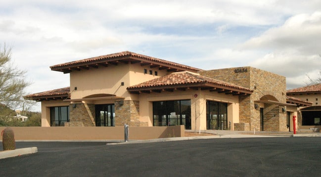

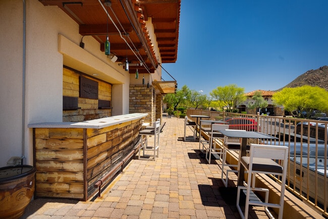
This Property Is For Sale
NEARBY LISTINGS FOR SALE OR LEASE
-
-
View all Scottsdale listings for sale on LoopNet.com
Property Detail
10434 E Jomax Rd
Phoenix-Mesa-Chandler, AZ
Villages At Pinnacle Peak Condominium
216-80-145
VILLAGES AT PINNACLE PEAK CONDOMINIUM MCR 721-49
Storebuilding
Maricopa
X
Arizona
04013C1330L
101
2025
0.10 AC
2025
North Scottsdale
216829
Phoenix
4,220 SF
DEMOGRAPHICS near 10434 E Jomax Rd
1 Mile
3 Mile
5 Mile
2024 Total Population
2,688
14,825
40,267
2029 Population
3,046
16,735
44,834
Pop Growth 2024-2029
+ 13.32%
+ 12.88%
+ 11.34%
Average Age
60
58
53
2024 Total Households
1,301
6,908
17,494
HH Growth 2024-2029
+ 13.37%
+ 13.06%
+ 11.58%
Median Household Inc
$170,351
$164,513
$150,706
Avg Household Size
2.00
2.10
2.30
2024 Avg HH Vehicles
2.00
2.00
2.00
Median Home Value
$989,870
$963,899
$909,769
Median Year Built
2000
1999
2000
Nearby Places
Map Layers
Map Styles
 Street
 Aerial
- Restaurants
- Banks
- Shops
- Fitness
- Groceries
PUBLIC TRANSPORTATION
AIRPORT
Phoenix Sky Harbor International
DRIVE
WALK
Distance
Phoenix Sky Harbor International
45 min
29.8 mi
Phoenix-Mesa Gateway
DRIVE
WALK
Distance
Phoenix-Mesa Gateway
65 min
45.1 mi
Nearby Properties
Address
Land Use
TOTAL SIZE
Lot Size
Zoning
Address
Land Use
TOTAL SIZE
Lot Size
Zoning
244,244 SF
23.25 AC
R-4R
Address
Land Use
TOTAL SIZE
Lot Size
Zoning
8.40 AC
Address
Land Use
TOTAL SIZE
Lot Size
Zoning
169,930 SF
656.35 AC
R1130
Address
Land Use
TOTAL SIZE
Lot Size
Zoning
270,264 SF
5.84 AC
C-C
Address
Land Use
TOTAL SIZE
Lot Size
Zoning
66,317 SF
20.82 AC
R-190
Address
Land Use
TOTAL SIZE
Lot Size
Zoning
100,378 SF
12.29 AC
C-C
Address
Land Use
TOTAL SIZE
Lot Size
Zoning
98,156 SF
15.08 AC
R-4R
Address
Land Use
TOTAL SIZE
Lot Size
Zoning
29,289 SF
24.71 AC
R-190
Address
Land Use
TOTAL SIZE
Lot Size
Zoning
6,569 SF
3.07 AC
R-190
Address
Land Use
TOTAL SIZE
Lot Size
Zoning
4,491 SF
34.11 AC
OS
Address
Land Use
TOTAL SIZE
Lot Size
Zoning
56,495 SF
94.89 AC
R143
Address
Land Use
TOTAL SIZE
Lot Size
Zoning
74,220 SF
1.99 AC
C-C
Address
Land Use
TOTAL SIZE
Lot Size
Zoning
32,508 SF
90.43 AC
O-S
Address
Land Use
TOTAL SIZE
Lot Size
Zoning
45,806 SF
5.68 AC
PAD
Address
Land Use
TOTAL SIZE
Lot Size
Zoning
14,801 SF
85.02 AC
R1-43
Address
Land Use
TOTAL SIZE
Lot Size
Zoning
4.81 AC
R-190
Address
Land Use
TOTAL SIZE
Lot Size
Zoning
4.36 AC
R-190
Address
Land Use
TOTAL SIZE
Lot Size
Zoning
32,678 SF
18.01 AC
Address
Land Use
TOTAL SIZE
Lot Size
Zoning
4.85 AC
R-190
Address
Land Use
TOTAL SIZE
Lot Size
Zoning
4.85 AC
R-190
Address
Land Use
TOTAL SIZE
Lot Size
Zoning
4.82 AC
R-190
Address
Land Use
TOTAL SIZE
Lot Size
Zoning
4.55 AC
R-190
Address
Land Use
TOTAL SIZE
Lot Size
Zoning
4.55 AC
R-190
Address
Land Use
TOTAL SIZE
Lot Size
Zoning
156,912 SF
4.21 AC
C-C
Address
Land Use
TOTAL SIZE
Lot Size
Zoning
8,753 SF
5.39 AC
C-C
Address
Land Use
TOTAL SIZE
Lot Size
Zoning
273.28 AC
R135
Address
Land Use
TOTAL SIZE
Lot Size
Zoning
15,897 SF
4.10 AC
R-190
Address
Land Use
TOTAL SIZE
Lot Size
Zoning
28,818 SF
2.78 AC
C-N
Address
Land Use
TOTAL SIZE
Lot Size
Zoning
13,012 SF
18.91 AC
R1190
The World's #1 Commercial Real Estate Marketplace
Connect with us
© 2026 CoStar Group
The information above has been obtained from sources believed reliable. While we do not doubt its accuracy we have not verified it and make no guarantee, warranty or representation about it. It is your responsibility to independently confirm its accuracy and completeness. Any projections, opinions, assumptions, or estimates used are for example only and do not represent the current or future performance of the property. The value of this transaction to you depends on tax and other factors which should be evaluated by your tax, financial, and legal advisors. You and your advisors should conduct a careful, independent investigation of the property to determine to your satisfaction the suitability of the property for your needs.