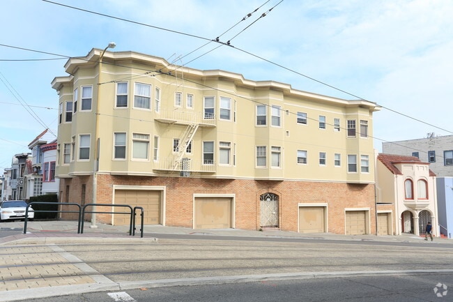
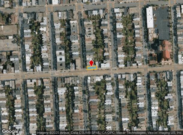
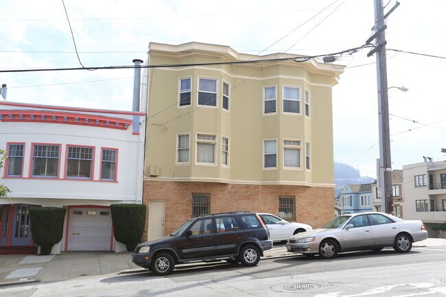
Property Record
1044 Judah St, San Francisco, CA 94122

NEARBY LISTINGS FOR SALE OR LEASE
Property Detail
1044 Judah St
San Francisco-Redwood City-South San Francisco, CA
Portion Outside Land Block #687
1770-024
San Francisco
Apartment
California
2024
24
2025
0.08 AC
030201
Inner Sunset
5,144 SF
San Francisco
DEMOGRAPHICS near 1044 Judah St
1 Mile
3 Mile
5 Mile
2024 Total Population
44,362
369,439
814,692
2029 Population
40,973
341,317
754,310
Pop Growth 2024-2029
(7.64%)
(7.61%)
(7.41%)
Average Age
43
43
42
2024 Total Households
17,663
155,875
343,722
HH Growth 2024-2029
(8.15%)
(8.08%)
(7.76%)
Median Household Inc
$134,711
$144,431
$125,921
Avg Household Size
2.40
2.30
2.20
2024 Avg HH Vehicles
1.00
1.00
1.00
Median Home Value
$1,128,306
$1,117,450
$1,097,831
Median Year Built
1947
1947
1949
Nearby Places
Map Layers
Map Styles
 Street
 Aerial
- Restaurants
- Banks
- Shops
- Fitness
- Groceries
PUBLIC TRANSPORTATION
TRANSIT/SUBWAY
Judah And 15Th Avenue (JUDAH - San Francisco Municipal Railway (MUNI Metro), N Judah - San Francisco Municipal Railway (MUNI Metro))
DRIVE
WALK
Distance
Judah And 15Th Avenue (JUDAH - San Francisco Municipal Railway (MUNI Metro), N Judah - San Francisco Municipal Railway (MUNI Metro))
1 min
1 min
0.1 mi
Judah And Funston (JUDAH - San Francisco Municipal Railway (MUNI Metro), N Judah - San Francisco Municipal Railway (MUNI Metro))
DRIVE
WALK
Distance
Judah And Funston (JUDAH - San Francisco Municipal Railway (MUNI Metro), N Judah - San Francisco Municipal Railway (MUNI Metro))
1 min
3 min
0.2 mi
Judah And 19Th Avenue (JUDAH - San Francisco Municipal Railway (MUNI Metro), N Judah - San Francisco Municipal Railway (MUNI Metro))
DRIVE
WALK
Distance
Judah And 19Th Avenue (JUDAH - San Francisco Municipal Railway (MUNI Metro), N Judah - San Francisco Municipal Railway (MUNI Metro))
3 min
3 min
0.2 mi
Judah And 12Th Avenue (JUDAH - San Francisco Municipal Railway (MUNI Metro), N Judah - San Francisco Municipal Railway (MUNI Metro))
DRIVE
WALK
Distance
Judah And 12Th Avenue (JUDAH - San Francisco Municipal Railway (MUNI Metro), N Judah - San Francisco Municipal Railway (MUNI Metro))
2 min
4 min
0.2 mi
Judah And 22Nd Avenue (JUDAH - San Francisco Municipal Railway (MUNI Metro), N Judah - San Francisco Municipal Railway (MUNI Metro))
DRIVE
WALK
Distance
Judah And 22Nd Avenue (JUDAH - San Francisco Municipal Railway (MUNI Metro), N Judah - San Francisco Municipal Railway (MUNI Metro))
1 min
7 min
0.4 mi
COMMUTER RAIL
San Francisco 4Th & King (Caltrain - Caltrain (Caltrain))
DRIVE
WALK
Distance
San Francisco 4Th & King (Caltrain - Caltrain (Caltrain))
13 min
5.2 mi
San Francisco Caltrain Station Southbound (Express - Caltrain (Caltrain), Limited - Caltrain (Caltrain), Local Weekday - Caltrain (Caltrain), Local Weekend - Caltrain (Caltrain))
DRIVE
WALK
Distance
San Francisco Caltrain Station Southbound (Express - Caltrain (Caltrain), Limited - Caltrain (Caltrain), Local Weekday - Caltrain (Caltrain), Local Weekend - Caltrain (Caltrain))
13 min
5.2 mi
AIRPORT
San Francisco International
DRIVE
WALK
Distance
San Francisco International
26 min
14.4 mi
Metro Oakland International
DRIVE
WALK
Distance
Metro Oakland International
40 min
24.1 mi
Freight Ports
Port of San Francisco
DRIVE
WALK
Distance
Port of San Francisco
16 min
6.0 mi
SALE & LEASE HISTORY
LISTING DATE
SALE/LEASE

Oct 09, 2019
For Sale
Nearby Properties
Address
Land Use
TOTAL SIZE
Lot Size
Zoning
Address
Land Use
TOTAL SIZE
Lot Size
Zoning
411,904 SF
21.74 AC
C2
Address
Land Use
TOTAL SIZE
Lot Size
Zoning
718 SF
18.55 AC
RH2
Address
Land Use
TOTAL SIZE
Lot Size
Zoning
409,895 SF
7.20 AC
RH3
Address
Land Use
TOTAL SIZE
Lot Size
Zoning
2.40 AC
NC3
Address
Land Use
TOTAL SIZE
Lot Size
Zoning
250,843 SF
6.62 AC
NC3
Address
Land Use
TOTAL SIZE
Lot Size
Zoning
225,851 SF
1.19 AC
NCT1
Address
Land Use
TOTAL SIZE
Lot Size
Zoning
17.91 AC
RH-2
Address
Land Use
TOTAL SIZE
Lot Size
Zoning
126,849 SF
0.60 AC
CM
Address
Land Use
TOTAL SIZE
Lot Size
Zoning
420,000 SF
0.79 AC
NC-3
Address
Land Use
TOTAL SIZE
Lot Size
Zoning
1.14 AC
P
Address
Land Use
TOTAL SIZE
Lot Size
Zoning
4.41 AC
RH-3/RM-2
Address
Land Use
TOTAL SIZE
Lot Size
Zoning
905,491 SF
10.27 AC
RM1
Address
Land Use
TOTAL SIZE
Lot Size
Zoning
230,310 SF
0.65 AC
NC3
Address
Land Use
TOTAL SIZE
Lot Size
Zoning
2.03 AC
C2
Address
Land Use
TOTAL SIZE
Lot Size
Zoning
210,935 SF
1.58 AC
UMU
Address
Land Use
TOTAL SIZE
Lot Size
Zoning
140,380 SF
0.53 AC
NC3
Address
Land Use
TOTAL SIZE
Lot Size
Zoning
88,900 SF
5.37 AC
NCS
Address
Land Use
TOTAL SIZE
Lot Size
Zoning
2.24 AC
RM3
Address
Land Use
TOTAL SIZE
Lot Size
Zoning
160,983 SF
1.84 AC
NC2
Address
Land Use
TOTAL SIZE
Lot Size
Zoning
75,989 SF
0.72 AC
Address
Land Use
TOTAL SIZE
Lot Size
Zoning
90,539 SF
2.28 AC
RH2
Address
Land Use
TOTAL SIZE
Lot Size
Zoning
14,525 SF
0.46 AC
NC2
Address
Land Use
TOTAL SIZE
Lot Size
Zoning
107,588 SF
1.04 AC
RM1
Address
Land Use
TOTAL SIZE
Lot Size
Zoning
Address
Land Use
TOTAL SIZE
Lot Size
Zoning
70,563 SF
0.42 AC
Address
Land Use
TOTAL SIZE
Lot Size
Zoning
88,402 SF
1.03 AC
RM1RM2
Address
Land Use
TOTAL SIZE
Lot Size
Zoning
73,491 SF
4.48 AC
C2
Address
Land Use
TOTAL SIZE
Lot Size
Zoning
146,036 SF
0.49 AC
RH3
Address
Land Use
TOTAL SIZE
Lot Size
Zoning
176,000 SF
1.64 AC
C2
Address
Land Use
TOTAL SIZE
Lot Size
Zoning
127,189 SF
0.74 AC
RM2
The World's #1 Commercial Real Estate Marketplace
Connect with us
© 2025 CoStar Group
The information above has been obtained from sources believed reliable. While we do not doubt its accuracy we have not verified it and make no guarantee, warranty or representation about it. It is your responsibility to independently confirm its accuracy and completeness. Any projections, opinions, assumptions, or estimates used are for example only and do not represent the current or future performance of the property. The value of this transaction to you depends on tax and other factors which should be evaluated by your tax, financial, and legal advisors. You and your advisors should conduct a careful, independent investigation of the property to determine to your satisfaction the suitability of the property for your needs.