Property Record
10440 Fm 2432 Rd, Conroe, TX 77303
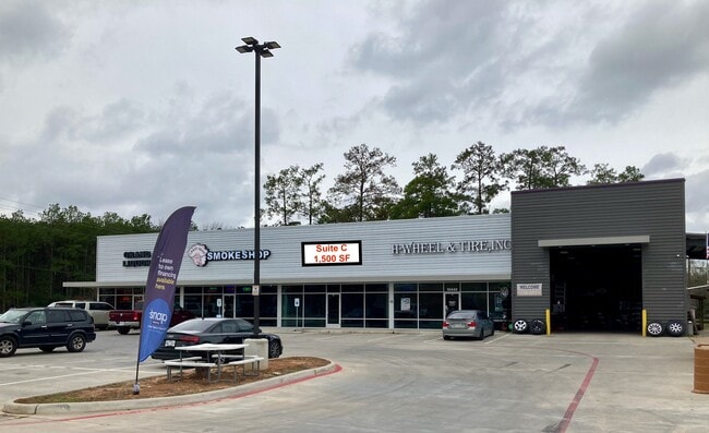

This Property Is For Sale
Property Detail
10440 Fm 2432 Rd
7139-00-00100
S713900 - MAX ALLEY AT FM 1484 PARTIAL REPLAT NO 1, BLOCK 1, RES A-1, ACRES 1.0053
Commercialnec
Montgomery
B and X Area of moderate flood hazard, usually the area between the limits of the 100-year and 500-year floods.
Texas
2024
1 AC
2025
Montgomery County
694104
Houston
7,296 SF
Houston-Pasadena-The Woodlands, TX
NEARBY LISTINGS FOR SALE OR LEASE
DEMOGRAPHICS near 10440 Fm 2432 Rd
1 mile
3 mile
5 mile
2025 Total Population
1,492
11,093
43,064
2030 Population
1,761
13,086
50,598
Pop Growth 2025-2030
+ 18.03%
+ 17.97%
+ 17.49%
Average Age
38
39
37
2025 Total Households
491
3,767
13,453
HH Growth 2025-2030
+ 18.53%
+ 18.53%
+ 18.83%
Median Household Inc
$110,348
$96,874
$72,351
Avg Household Size
3.10
2.90
3.00
2025 Avg HH Vehicles
2.00
2.00
2.00
Median Home Value
$339,516
$276,629
$251,375
Median Year Built
2007
2006
2005
Nearby Places
Map Layers
Map Styles
 Street
 Aerial
Layers
 Traffic
 Biking
Places
Listings with unknown addresses are not visible on the map
- Restaurants
- Banks
- Shops
- Fitness
- Groceries
PUBLIC TRANSPORTATION
AIRPORT
George Bush Intcntl/Houston
Drive
Walk
Distance
George Bush Intcntl/Houston
51 min
39.5 mi
Freight Ports
Port of Houston
Drive
Walk
Distance
Port of Houston
73 min
55.2 mi
Nearby Properties
Address
Land Use
TOTAL SIZE
Lot Size
Zoning
Address
Land Use
TOTAL SIZE
Lot Size
Zoning
165,071 SF
16.01 AC
Address
Land Use
TOTAL SIZE
Lot Size
Zoning
123,674 SF
21.67 AC
Address
Land Use
TOTAL SIZE
Lot Size
Zoning
236,986 SF
19.54 AC
Address
Land Use
TOTAL SIZE
Lot Size
Zoning
271,688 SF
114.31 AC
Address
Land Use
TOTAL SIZE
Lot Size
Zoning
38,742 SF
249.26 AC
1
Address
Land Use
TOTAL SIZE
Lot Size
Zoning
82,560 SF
1
Address
Land Use
TOTAL SIZE
Lot Size
Zoning
255 SF
254.02 AC
Address
Land Use
TOTAL SIZE
Lot Size
Zoning
80,044 SF
493.71 AC
Address
Land Use
TOTAL SIZE
Lot Size
Zoning
25,011 SF
8.57 AC
Address
Land Use
TOTAL SIZE
Lot Size
Zoning
24,488 SF
51.81 AC
1
Address
Land Use
TOTAL SIZE
Lot Size
Zoning
10,857 SF
2.91 AC
Address
Land Use
TOTAL SIZE
Lot Size
Zoning
47,285 SF
3 AC
Address
Land Use
TOTAL SIZE
Lot Size
Zoning
73,762 SF
12.47 AC
1
Address
Land Use
TOTAL SIZE
Lot Size
Zoning
40,500 SF
10 AC
Address
Land Use
TOTAL SIZE
Lot Size
Zoning
39,453 SF
23.68 AC
1
Address
Land Use
TOTAL SIZE
Lot Size
Zoning
23.64 AC
Address
Land Use
TOTAL SIZE
Lot Size
Zoning
8,880 SF
3 AC
4
Address
Land Use
TOTAL SIZE
Lot Size
Zoning
56,320 SF
493.71 AC
Address
Land Use
TOTAL SIZE
Lot Size
Zoning
12,472 SF
2.51 AC
Address
Land Use
TOTAL SIZE
Lot Size
Zoning
30,100 SF
4 AC
Address
Land Use
TOTAL SIZE
Lot Size
Zoning
8,320 SF
1.05 AC
Address
Land Use
TOTAL SIZE
Lot Size
Zoning
38,360 SF
6 AC
Address
Land Use
TOTAL SIZE
Lot Size
Zoning
26,200 SF
493.71 AC
Address
Land Use
TOTAL SIZE
Lot Size
Zoning
22,286 SF
Address
Land Use
TOTAL SIZE
Lot Size
Zoning
21,686 SF
7.20 AC
1
Address
Land Use
TOTAL SIZE
Lot Size
Zoning
27,712 SF
2.78 AC
1
Address
Land Use
TOTAL SIZE
Lot Size
Zoning
5,312 SF
126.42 AC
4
The World's #1 Commercial Real Estate Marketplace
Connect with us
© 2026 CoStar Group
The information above has been obtained from sources believed reliable. While we do not doubt its accuracy we have not verified it and make no guarantee, warranty or representation about it. It is your responsibility to independently confirm its accuracy and completeness. Any projections, opinions, assumptions, or estimates used are for example only and do not represent the current or future performance of the property. The value of this transaction to you depends on tax and other factors which should be evaluated by your tax, financial, and legal advisors. You and your advisors should conduct a careful, independent investigation of the property to determine to your satisfaction the suitability of the property for your needs.