Property Record
1045 State Route 173, Asbury, NJ 08802
NEARBY LISTINGS FOR SALE OR LEASE
Property Detail
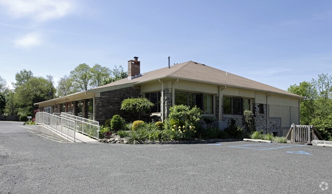
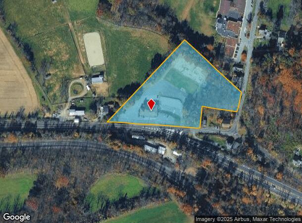
1045 State Route 173
02-00027-0000-00010
Hunterdon
Restaurantbuilding
New Jersey
A
10
34041C0316E
4.70 AC
2024
Hunterdon
2025
Northern New Jersey
010400
Newark, NJ
6,271 SF
DEMOGRAPHICS near 1045 State Route 173
1 mile
3 mile
5 mile
2024 Total Population
337
5,209
16,169
2029 Population
338
5,250
16,348
Pop Growth 2024-2029
+ 0.30%
+ 0.79%
+ 1.11%
Average Age
44
44
44
2024 Total Households
124
1,935
5,625
HH Growth 2024-2029
+ 0.81%
+ 0.72%
+ 1.24%
Median Household Inc
$125,735
$116,424
$123,159
Avg Household Size
2.70
2.70
2.70
2024 Avg HH Vehicles
2.00
2.00
3.00
Median Home Value
$450,000
$426,397
$434,419
Median Year Built
1975
1972
1976
Nearby Places
Map Layers
Map Styles
 Street
 Aerial
Transit
 Traffic
 Biking
Places
Listings with unknown addresses are not visible on the map
- Restaurants
- Banks
- Shops
- Fitness
- Groceries
PUBLIC TRANSPORTATION
COMMUTER RAIL
Annandale (Raritan Valley Line - NJ Transit Commuter Rail (NJ Transit))
Drive
Walk
Distance
Annandale (Raritan Valley Line - NJ Transit Commuter Rail (NJ Transit))
15 min
9.8 mi
AIRPORT
Lehigh Valley International
Drive
Walk
Distance
Lehigh Valley International
40 min
24.9 mi
Trenton Mercer
Drive
Walk
Distance
Trenton Mercer
58 min
37.1 mi
Freight Ports
Maher Terminal
Drive
Walk
Distance
Maher Terminal
66 min
51.5 mi
Nearby Properties
Address
Land Use
TOTAL SIZE
Lot Size
Zoning
Address
Land Use
TOTAL SIZE
Lot Size
Zoning
9.05 AC
MR
Address
Land Use
TOTAL SIZE
Lot Size
Zoning
800 SF
28.04 AC
MR
Address
Land Use
TOTAL SIZE
Lot Size
Zoning
1,392 SF
5.89 AC
PC
Address
Land Use
TOTAL SIZE
Lot Size
Zoning
185.60 AC
AR
Address
Land Use
TOTAL SIZE
Lot Size
Zoning
11.15 AC
MFG
Address
Land Use
TOTAL SIZE
Lot Size
Zoning
12.02 AC
B-2
Address
Land Use
TOTAL SIZE
Lot Size
Zoning
14.29 AC
B-2
Address
Land Use
TOTAL SIZE
Lot Size
Zoning
14.70 AC
MFG
Address
Land Use
TOTAL SIZE
Lot Size
Zoning
13,478 SF
0.98 AC
R-3
Address
Land Use
TOTAL SIZE
Lot Size
Zoning
6,004 SF
5 AC
RC
Address
Land Use
TOTAL SIZE
Lot Size
Zoning
153.13 AC
MR
Address
Land Use
TOTAL SIZE
Lot Size
Zoning
8,218 SF
1 AC
RC
Address
Land Use
TOTAL SIZE
Lot Size
Zoning
6.04 AC
ROM
Address
Land Use
TOTAL SIZE
Lot Size
Zoning
3,840 SF
3.32 AC
B-2
Address
Land Use
TOTAL SIZE
Lot Size
Zoning
4.07 AC
PC
Address
Land Use
TOTAL SIZE
Lot Size
Zoning
875 SF
0.67 AC
DB
Address
Land Use
TOTAL SIZE
Lot Size
Zoning
2,672 SF
4.52 AC
B-2
Address
Land Use
TOTAL SIZE
Lot Size
Zoning
3,120 SF
7 AC
MR
Address
Land Use
TOTAL SIZE
Lot Size
Zoning
51.80 AC
MR
Address
Land Use
TOTAL SIZE
Lot Size
Zoning
9,979 SF
0.46 AC
R-2
Address
Land Use
TOTAL SIZE
Lot Size
Zoning
97.27 AC
MR
Address
Land Use
TOTAL SIZE
Lot Size
Zoning
0.47 AC
C-1
Address
Land Use
TOTAL SIZE
Lot Size
Zoning
43.52 AC
MR
Address
Land Use
TOTAL SIZE
Lot Size
Zoning
7,109 SF
8.57 AC
MR
Address
Land Use
TOTAL SIZE
Lot Size
Zoning
4,210 SF
7.34 AC
MR
Address
Land Use
TOTAL SIZE
Lot Size
Zoning
4,692 SF
1.50 AC
MR
Address
Land Use
TOTAL SIZE
Lot Size
Zoning
39.64 AC
MR
Address
Land Use
TOTAL SIZE
Lot Size
Zoning
2,788 SF
8 AC
AR
Address
Land Use
TOTAL SIZE
Lot Size
Zoning
3,250 SF
3.32 AC
VCCM
Address
Land Use
TOTAL SIZE
Lot Size
Zoning
4,351 SF
1.50 AC
MR
The World's #1 Commercial Real Estate Marketplace
Connect with us
© 2026 CoStar Group
The information above has been obtained from sources believed reliable. While we do not doubt its accuracy we have not verified it and make no guarantee, warranty or representation about it. It is your responsibility to independently confirm its accuracy and completeness. Any projections, opinions, assumptions, or estimates used are for example only and do not represent the current or future performance of the property. The value of this transaction to you depends on tax and other factors which should be evaluated by your tax, financial, and legal advisors. You and your advisors should conduct a careful, independent investigation of the property to determine to your satisfaction the suitability of the property for your needs.