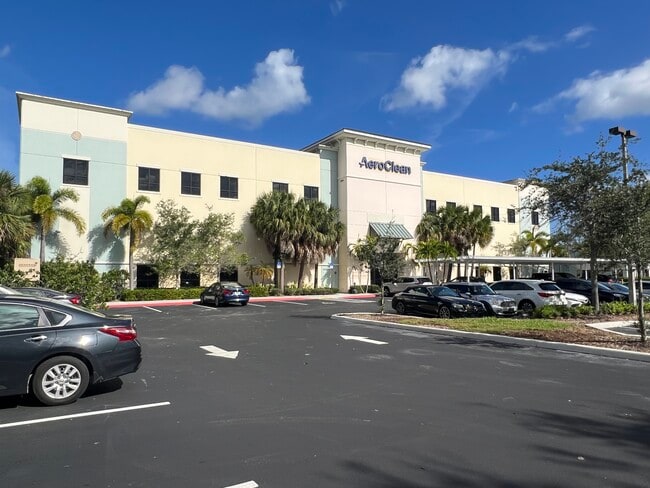
Property Record
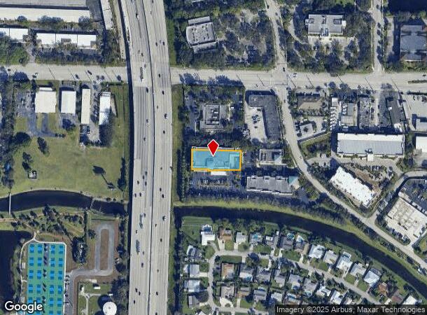
10455 Riverside Dr, Palm Beach Gardens, FL 33410

Current Lease Availabilities
NEARBY LISTINGS FOR SALE OR LEASE
Property Detail
10455 Riverside Dr
West Palm Beach-Boca Raton-Delray Beach, FL
Gardens Commerce Center
52-43-42-07-44-001-0030
GARDENS COMMERCE CENTER SLY 102.53 FT OF NLY 118.61 FT OF ELY 243.52 FT OF WLY 273.52 FT PT OF TR A K/A LT 3 IN OR23520P1019
Warehouse
Palm Beach
X
Florida
12099C0378F
3
2024
0.55 AC
2024
Palm Beach Gardens
000902
South Florida
44,300 SF
DEMOGRAPHICS near 10455 Riverside Dr
1 Mile
3 Mile
5 Mile
2024 Total Population
10,773
87,146
173,616
2029 Population
11,096
90,564
182,661
Pop Growth 2024-2029
+ 3.00%
+ 3.92%
+ 5.21%
Average Age
43
45
45
2024 Total Households
4,910
37,502
73,859
HH Growth 2024-2029
+ 2.63%
+ 3.53%
+ 4.99%
Median Household Inc
$82,221
$85,120
$82,634
Avg Household Size
2.10
2.20
2.20
2024 Avg HH Vehicles
2.00
2.00
2.00
Median Home Value
$328,788
$399,098
$429,019
Median Year Built
1978
1988
1988
Nearby Places
- Restaurants
- Banks
- Shops
- Fitness
- Groceries
PUBLIC TRANSPORTATION
COMMUTER RAIL
Mangonia Park (Tri-County Commuter - South Florida Regional Transportation Authority (Tri-Rail))
DRIVE
WALK
Distance
Mangonia Park (Tri-County Commuter - South Florida Regional Transportation Authority (Tri-Rail))
13 min
6.3 mi
AIRPORT
Palm Beach International
DRIVE
WALK
Distance
Palm Beach International
23 min
15.1 mi
Freight Ports
Port of Palm Beach
DRIVE
WALK
Distance
Port of Palm Beach
12 min
5.7 mi
Nearby Properties
Address
Land Use
TOTAL SIZE
Lot Size
Zoning
Address
Land Use
TOTAL SIZE
Lot Size
Zoning
736,483 SF
43.51 AC
CG1
Address
Land Use
TOTAL SIZE
Lot Size
Zoning
557,199 SF
46.91 AC
PCD
Address
Land Use
TOTAL SIZE
Lot Size
Zoning
621,404 SF
29.95 AC
PCD
Address
Land Use
TOTAL SIZE
Lot Size
Zoning
545,613 SF
19.47 AC
PCD
Address
Land Use
TOTAL SIZE
Lot Size
Zoning
650,167 SF
27.64 AC
PCD
Address
Land Use
TOTAL SIZE
Lot Size
Zoning
390,568 SF
38.79 AC
NZ
Address
Land Use
TOTAL SIZE
Lot Size
Zoning
574,456 SF
43.11 AC
PCD
Address
Land Use
TOTAL SIZE
Lot Size
Zoning
362,386 SF
22.51 AC
PCD
Address
Land Use
TOTAL SIZE
Lot Size
Zoning
351,267 SF
11.12 AC
PUD
Address
Land Use
TOTAL SIZE
Lot Size
Zoning
390,319 SF
44.34 AC
PCD
Address
Land Use
TOTAL SIZE
Lot Size
Zoning
308,087 SF
68.94 AC
P/I
Address
Land Use
TOTAL SIZE
Lot Size
Zoning
351,788 SF
13.75 AC
PCD
Address
Land Use
TOTAL SIZE
Lot Size
Zoning
399,171 SF
6.60 AC
PCD
Address
Land Use
TOTAL SIZE
Lot Size
Zoning
416,171 SF
19.24 AC
R-PUD
Address
Land Use
TOTAL SIZE
Lot Size
Zoning
195,263 SF
2.73 AC
PCD
Address
Land Use
TOTAL SIZE
Lot Size
Zoning
680,979 SF
44.87 AC
PCD
Address
Land Use
TOTAL SIZE
Lot Size
Zoning
406,434 SF
40.60 AC
P/I
Address
Land Use
TOTAL SIZE
Lot Size
Zoning
248,945 SF
10.87 AC
PO
Address
Land Use
TOTAL SIZE
Lot Size
Zoning
23.07 AC
CLIC
Address
Land Use
TOTAL SIZE
Lot Size
Zoning
270,888 SF
8.93 AC
RH
Address
Land Use
TOTAL SIZE
Lot Size
Zoning
59,520 SF
19.04 AC
C-S
Address
Land Use
TOTAL SIZE
Lot Size
Zoning
347,834 SF
8.92 AC
PCD
Address
Land Use
TOTAL SIZE
Lot Size
Zoning
150,114 SF
3.20 AC
MXD
Address
Land Use
TOTAL SIZE
Lot Size
Zoning
291,437 SF
22.02 AC
PO
Address
Land Use
TOTAL SIZE
Lot Size
Zoning
266,196 SF
17.61 AC
R-3
Address
Land Use
TOTAL SIZE
Lot Size
Zoning
109,243 SF
9.14 AC
CG1
Address
Land Use
TOTAL SIZE
Lot Size
Zoning
180,563 SF
54.46 AC
P/I
Address
Land Use
TOTAL SIZE
Lot Size
Zoning
286,353 SF
22.12 AC
RH
Address
Land Use
TOTAL SIZE
Lot Size
Zoning
215,592 SF
38.87 AC
RL3
Address
Land Use
TOTAL SIZE
Lot Size
Zoning
381,665 SF
26.01 AC
PCD
The World's #1 Commercial Real Estate Marketplace
Connect with us
© 2025 CoStar Group
The information above has been obtained from sources believed reliable. While we do not doubt its accuracy we have not verified it and make no guarantee, warranty or representation about it. It is your responsibility to independently confirm its accuracy and completeness. Any projections, opinions, assumptions, or estimates used are for example only and do not represent the current or future performance of the property. The value of this transaction to you depends on tax and other factors which should be evaluated by your tax, financial, and legal advisors. You and your advisors should conduct a careful, independent investigation of the property to determine to your satisfaction the suitability of the property for your needs.