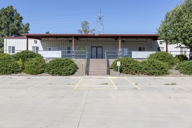
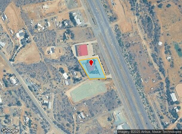
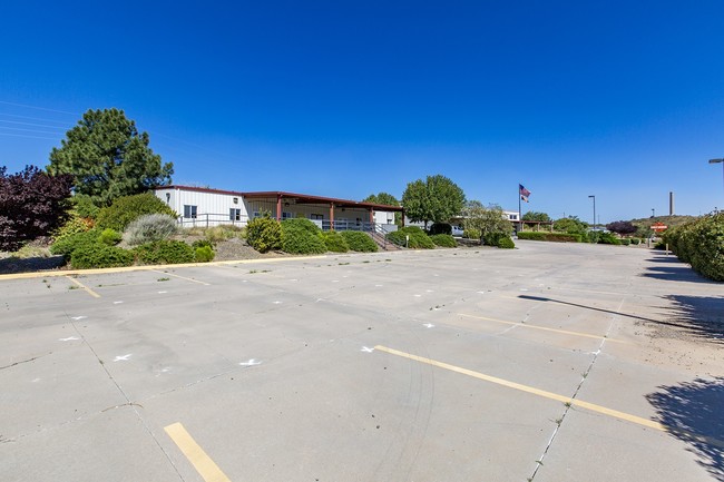
Property Record
10456 S State Route 69, Mayer, AZ 86333
Current Lease Availabilities
NEARBY LISTINGS FOR SALE OR LEASE
Property Detail
10456 S State Route 69
500-16-004J
Highlands
Restaurantbuilding
HIGHLANDS UNIT 2 M&P 12/90 AN IRREG PTN PCL 9 AKA LS 160/47 PCL B NE PCL COR APPROX 193.72SLY OF NE COR PCL 9 26-12-1E CONT 1.15A C
X
Yavapai
04025C2488H
Arizona
2024
1.15 AC
2026
Prescott & Sedona
001502
Other Market Areas
6,030 SF
Prescott, AZ
DEMOGRAPHICS near 10456 S State Route 69
1 Mile
3 Mile
5 Mile
2024 Total Population
253
696
1,889
2029 Population
258
745
2,043
Pop Growth 2024-2029
+ 1.98%
+ 7.04%
+ 8.15%
Average Age
50
49
49
2024 Total Households
117
321
870
HH Growth 2024-2029
+ 2.56%
+ 7.48%
+ 8.51%
Median Household Inc
$52,647
$50,385
$49,610
Avg Household Size
2.10
2.10
2.10
2024 Avg HH Vehicles
2.00
2.00
2.00
Median Home Value
$235,714
$190,624
$185,293
Median Year Built
1985
1987
1988
Nearby Places
- Restaurants
- Banks
- Shops
- Fitness
- Groceries
Nearby Properties
Address
Land Use
TOTAL SIZE
Lot Size
Zoning
Address
Land Use
TOTAL SIZE
Lot Size
Zoning
50,757 SF
7.24 AC
Address
Land Use
TOTAL SIZE
Lot Size
Zoning
16,549 SF
34.61 AC
Address
Land Use
TOTAL SIZE
Lot Size
Zoning
9,600 SF
2.01 AC
Address
Land Use
TOTAL SIZE
Lot Size
Zoning
6,812 SF
3 AC
Address
Land Use
TOTAL SIZE
Lot Size
Zoning
16,680 SF
4.27 AC
Address
Land Use
TOTAL SIZE
Lot Size
Zoning
1,440 SF
10.04 AC
Address
Land Use
TOTAL SIZE
Lot Size
Zoning
9,672 SF
1.17 AC
Address
Land Use
TOTAL SIZE
Lot Size
Zoning
11,892 SF
1.23 AC
Address
Land Use
TOTAL SIZE
Lot Size
Zoning
8,222 SF
0.42 AC
Address
Land Use
TOTAL SIZE
Lot Size
Zoning
6,077 SF
3.87 AC
Address
Land Use
TOTAL SIZE
Lot Size
Zoning
7,451 SF
1.03 AC
Address
Land Use
TOTAL SIZE
Lot Size
Zoning
4,384 SF
0.84 AC
Address
Land Use
TOTAL SIZE
Lot Size
Zoning
279.04 AC
Address
Land Use
TOTAL SIZE
Lot Size
Zoning
3,360 SF
0.97 AC
Address
Land Use
TOTAL SIZE
Lot Size
Zoning
4,015 SF
10 AC
Address
Land Use
TOTAL SIZE
Lot Size
Zoning
4,870 SF
0.85 AC
Address
Land Use
TOTAL SIZE
Lot Size
Zoning
6,101 SF
0.90 AC
Address
Land Use
TOTAL SIZE
Lot Size
Zoning
3,044 SF
0.21 AC
Address
Land Use
TOTAL SIZE
Lot Size
Zoning
10,972 SF
6.02 AC
Address
Land Use
TOTAL SIZE
Lot Size
Zoning
24 SF
6.34 AC
Address
Land Use
TOTAL SIZE
Lot Size
Zoning
4,919 SF
0.80 AC
Address
Land Use
TOTAL SIZE
Lot Size
Zoning
6,225 SF
1.30 AC
Address
Land Use
TOTAL SIZE
Lot Size
Zoning
3,240 SF
4.25 AC
Address
Land Use
TOTAL SIZE
Lot Size
Zoning
2,886 SF
10.38 AC
Address
Land Use
TOTAL SIZE
Lot Size
Zoning
2,548 SF
4.90 AC
Address
Land Use
TOTAL SIZE
Lot Size
Zoning
2,688 SF
4.06 AC
Address
Land Use
TOTAL SIZE
Lot Size
Zoning
Address
Land Use
TOTAL SIZE
Lot Size
Zoning
3,054 SF
0.88 AC
The World's #1 Commercial Real Estate Marketplace
Connect with us
© 2025 CoStar Group
The information above has been obtained from sources believed reliable. While we do not doubt its accuracy we have not verified it and make no guarantee, warranty or representation about it. It is your responsibility to independently confirm its accuracy and completeness. Any projections, opinions, assumptions, or estimates used are for example only and do not represent the current or future performance of the property. The value of this transaction to you depends on tax and other factors which should be evaluated by your tax, financial, and legal advisors. You and your advisors should conduct a careful, independent investigation of the property to determine to your satisfaction the suitability of the property for your needs.