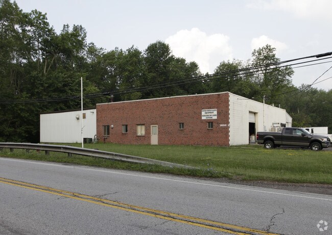
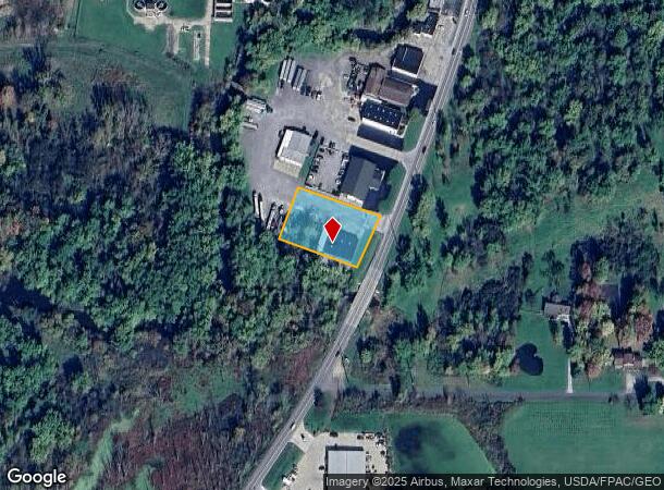
Property Record
10465 Main St, Mantua, OH 44255

NEARBY LISTINGS FOR SALE OR LEASE
Property Detail
10465 Main St
Akron, OH
Atwater
24-041-40-00-001-005
ATWATER LOT 40 & 41
Storebuilding
Portage
AE
Ohio
39133C0063D
40,41
2024
0.80 AC
2024
Portage County
600200
Cleveland
9,000 SF
DEMOGRAPHICS near 10465 Main St
1 Mile
3 Mile
5 Mile
2024 Total Population
1,147
4,870
13,301
2029 Population
1,146
4,880
13,350
Pop Growth 2024-2029
(0.09%)
+ 0.21%
+ 0.37%
Average Age
44
44
43
2024 Total Households
482
1,957
5,247
HH Growth 2024-2029
(0.21%)
+ 0.15%
+ 0.29%
Median Household Inc
$77,273
$73,299
$70,988
Avg Household Size
2.30
2.40
2.40
2024 Avg HH Vehicles
2.00
2.00
2.00
Median Home Value
$208,468
$215,409
$199,936
Median Year Built
1951
1965
1968
Nearby Places
Map Layers
Map Styles
 Street
 Aerial
- Restaurants
- Banks
- Shops
- Fitness
- Groceries
PUBLIC TRANSPORTATION
AIRPORT
Akron-Canton Regional
DRIVE
WALK
Distance
Akron-Canton Regional
53 min
39.9 mi
Cleveland-Hopkins International
DRIVE
WALK
Distance
Cleveland-Hopkins International
56 min
43.4 mi
Nearby Properties
Address
Land Use
TOTAL SIZE
Lot Size
Zoning
Address
Land Use
TOTAL SIZE
Lot Size
Zoning
1,021,440 SF
73.29 AC
Address
Land Use
TOTAL SIZE
Lot Size
Zoning
129,894 SF
32.27 AC
Address
Land Use
TOTAL SIZE
Lot Size
Zoning
211,593 SF
64.96 AC
Address
Land Use
TOTAL SIZE
Lot Size
Zoning
14,307 SF
164.59 AC
Address
Land Use
TOTAL SIZE
Lot Size
Zoning
1,880 SF
391.37 AC
Address
Land Use
TOTAL SIZE
Lot Size
Zoning
21,651 SF
16.29 AC
Address
Land Use
TOTAL SIZE
Lot Size
Zoning
38,460 SF
15 AC
Address
Land Use
TOTAL SIZE
Lot Size
Zoning
3.45 AC
Address
Land Use
TOTAL SIZE
Lot Size
Zoning
18,700 SF
3 AC
Address
Land Use
TOTAL SIZE
Lot Size
Zoning
25,080 SF
11.83 AC
Address
Land Use
TOTAL SIZE
Lot Size
Zoning
8,120 SF
77.58 AC
Address
Land Use
TOTAL SIZE
Lot Size
Zoning
7,163 SF
27.86 AC
Address
Land Use
TOTAL SIZE
Lot Size
Zoning
3,170 SF
183.40 AC
Address
Land Use
TOTAL SIZE
Lot Size
Zoning
6,898 SF
134.22 AC
Address
Land Use
TOTAL SIZE
Lot Size
Zoning
34,840 SF
2 AC
Address
Land Use
TOTAL SIZE
Lot Size
Zoning
30,464 SF
4.18 AC
Address
Land Use
TOTAL SIZE
Lot Size
Zoning
2,800 SF
59.38 AC
Address
Land Use
TOTAL SIZE
Lot Size
Zoning
27,642 SF
24.13 AC
Address
Land Use
TOTAL SIZE
Lot Size
Zoning
12,896 SF
3.02 AC
Address
Land Use
TOTAL SIZE
Lot Size
Zoning
24,225 SF
1 AC
Address
Land Use
TOTAL SIZE
Lot Size
Zoning
152,420 SF
8.95 AC
Address
Land Use
TOTAL SIZE
Lot Size
Zoning
8,826 SF
13.30 AC
Address
Land Use
TOTAL SIZE
Lot Size
Zoning
5,168 SF
93.03 AC
Address
Land Use
TOTAL SIZE
Lot Size
Zoning
1,694 SF
54.92 AC
Address
Land Use
TOTAL SIZE
Lot Size
Zoning
9,684 SF
1.21 AC
Address
Land Use
TOTAL SIZE
Lot Size
Zoning
11,664 SF
2 AC
Address
Land Use
TOTAL SIZE
Lot Size
Zoning
30,507 SF
6.41 AC
Address
Land Use
TOTAL SIZE
Lot Size
Zoning
55,716 SF
1 AC
Address
Land Use
TOTAL SIZE
Lot Size
Zoning
8,409 SF
112.25 AC
Address
Land Use
TOTAL SIZE
Lot Size
Zoning
16,100 SF
2.87 AC
The World's #1 Commercial Real Estate Marketplace
Connect with us
© 2025 CoStar Group
The information above has been obtained from sources believed reliable. While we do not doubt its accuracy we have not verified it and make no guarantee, warranty or representation about it. It is your responsibility to independently confirm its accuracy and completeness. Any projections, opinions, assumptions, or estimates used are for example only and do not represent the current or future performance of the property. The value of this transaction to you depends on tax and other factors which should be evaluated by your tax, financial, and legal advisors. You and your advisors should conduct a careful, independent investigation of the property to determine to your satisfaction the suitability of the property for your needs.