Property Record
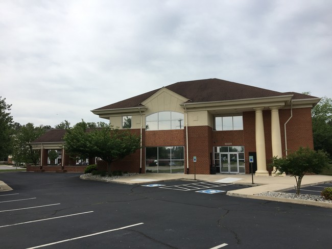
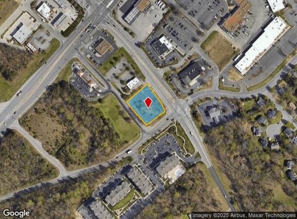
10469 Atlee Station Rd, Ashland, VA 23005
This Property Is For Sale
NEARBY LISTINGS FOR SALE OR LEASE
Property Detail
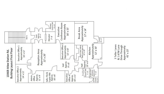
10469 Atlee Station Rd
Richmond, VA
Beechwood Commercial
7787-96-9443
BEECHWOOD COMM CTR
Commercialnec
Hanover
X
Virginia
51085C0304C
2
2025
0.67 AC
2025
I-95 North/Chamberlayne
320805
Richmond VA
5,814 SF
DEMOGRAPHICS near 10469 Atlee Station Rd
1 Mile
3 Mile
5 Mile
2024 Total Population
3,773
29,822
75,892
2029 Population
4,010
31,520
78,566
Pop Growth 2024-2029
+ 6.28%
+ 5.69%
+ 3.52%
Average Age
40
40
41
2024 Total Households
1,403
11,230
29,105
HH Growth 2024-2029
+ 6.49%
+ 5.67%
+ 3.45%
Median Household Inc
$112,093
$98,775
$93,001
Avg Household Size
2.60
2.60
2.60
2024 Avg HH Vehicles
2.00
2.00
2.00
Median Home Value
$320,145
$325,064
$313,895
Median Year Built
1992
1996
1990
Nearby Places
Map Layers
Map Styles
 Street
 Aerial
- Restaurants
- Banks
- Shops
- Fitness
- Groceries
PUBLIC TRANSPORTATION
COMMUTER RAIL
DRIVE
WALK
Distance
12 min
7.3 mi
DRIVE
WALK
Distance
16 min
8.7 mi
AIRPORT
Richmond International
DRIVE
WALK
Distance
Richmond International
29 min
20.3 mi
Freight Ports
Virginia Port Authority - Richmond
DRIVE
WALK
Distance
Virginia Port Authority - Richmond
30 min
19.9 mi
Nearby Properties
Address
Land Use
TOTAL SIZE
Lot Size
Zoning
Address
Land Use
TOTAL SIZE
Lot Size
Zoning
136.01 AC
A-1
Address
Land Use
TOTAL SIZE
Lot Size
Zoning
210.61 AC
M-2
Address
Land Use
TOTAL SIZE
Lot Size
Zoning
95.24 AC
A-1
Address
Land Use
TOTAL SIZE
Lot Size
Zoning
32,407 SF
1.18 AC
UMU
Address
Land Use
TOTAL SIZE
Lot Size
Zoning
347,648 SF
24.75 AC
R-5
Address
Land Use
TOTAL SIZE
Lot Size
Zoning
186,034 SF
13.86 AC
B-3C
Address
Land Use
TOTAL SIZE
Lot Size
Zoning
34.69 AC
A-1
Address
Land Use
TOTAL SIZE
Lot Size
Zoning
43.49 AC
M-2
Address
Land Use
TOTAL SIZE
Lot Size
Zoning
59.30 AC
M-2
Address
Land Use
TOTAL SIZE
Lot Size
Zoning
135,874 SF
31.99 AC
MIXE
Address
Land Use
TOTAL SIZE
Lot Size
Zoning
102,942 SF
71.86 AC
MIXE
Address
Land Use
TOTAL SIZE
Lot Size
Zoning
50.20 AC
M-2
Address
Land Use
TOTAL SIZE
Lot Size
Zoning
39.96 AC
A-1
Address
Land Use
TOTAL SIZE
Lot Size
Zoning
2,952 SF
20.87 AC
RM
Address
Land Use
TOTAL SIZE
Lot Size
Zoning
320,540 SF
18.50 AC
M-2
Address
Land Use
TOTAL SIZE
Lot Size
Zoning
216,900 SF
13.41 AC
R-6
Address
Land Use
TOTAL SIZE
Lot Size
Zoning
159,432 SF
14 AC
R-5
Address
Land Use
TOTAL SIZE
Lot Size
Zoning
138,140 SF
7.66 AC
R-6
Address
Land Use
TOTAL SIZE
Lot Size
Zoning
142,140 SF
10.01 AC
R-5
Address
Land Use
TOTAL SIZE
Lot Size
Zoning
21 AC
M-2
Address
Land Use
TOTAL SIZE
Lot Size
Zoning
25.93 AC
M-2
Address
Land Use
TOTAL SIZE
Lot Size
Zoning
24.80 AC
M-2
Address
Land Use
TOTAL SIZE
Lot Size
Zoning
76,749 SF
22.25 AC
A-1
Address
Land Use
TOTAL SIZE
Lot Size
Zoning
31.70 AC
M-2
Address
Land Use
TOTAL SIZE
Lot Size
Zoning
128,005 SF
16.91 AC
M-1
Address
Land Use
TOTAL SIZE
Lot Size
Zoning
215,072 SF
16.32 AC
M-2
Address
Land Use
TOTAL SIZE
Lot Size
Zoning
17.80 AC
B-3
Address
Land Use
TOTAL SIZE
Lot Size
Zoning
129,663 SF
14 AC
MIXE
Address
Land Use
TOTAL SIZE
Lot Size
Zoning
89,982 SF
10.20 AC
MIXE
Address
Land Use
TOTAL SIZE
Lot Size
Zoning
3.42 AC
R-1
The World's #1 Commercial Real Estate Marketplace
Connect with us
© 2026 CoStar Group
The information above has been obtained from sources believed reliable. While we do not doubt its accuracy we have not verified it and make no guarantee, warranty or representation about it. It is your responsibility to independently confirm its accuracy and completeness. Any projections, opinions, assumptions, or estimates used are for example only and do not represent the current or future performance of the property. The value of this transaction to you depends on tax and other factors which should be evaluated by your tax, financial, and legal advisors. You and your advisors should conduct a careful, independent investigation of the property to determine to your satisfaction the suitability of the property for your needs.