Property Record
1047 Macarthur Rd, Reading, PA 19605


Save to a Folder
{{folder.Name}}
{{folder.ListingIds.length}} Properties
{{folder.ListingIds.length}} Property
Create a New Folder
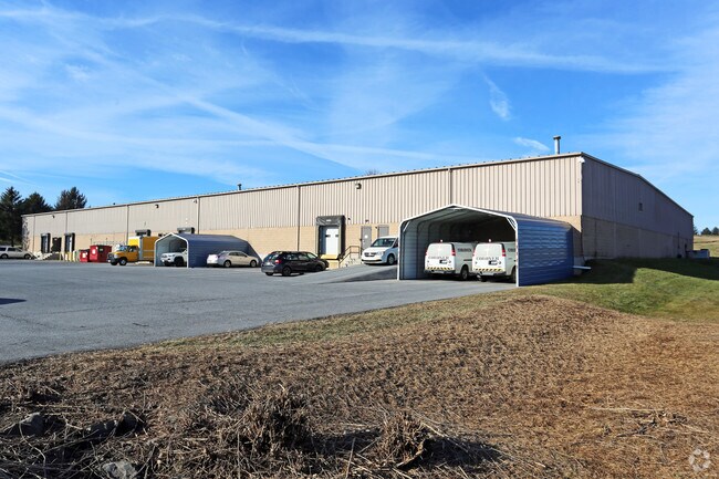
Property Detail
1047 Macarthur Rd
27-4398-01-45-2922
Berks
Warehouse
Pennsylvania
B and X Area of moderate flood hazard, usually the area between the limits of the 100-year and 500-year floods.
17
2026
3.09 AC
2026
Berks
010304
Philadelphia
35,044 SF
Reading, PA
NEARBY LISTINGS FOR SALE OR LEASE
DEMOGRAPHICS near 1047 Macarthur Rd
1 mile
3 mile
5 mile
2025 Total Population
758
39,517
177,983
2030 Population
788
40,407
181,449
Pop Growth 2025-2030
+ 3.96%
+ 2.25%
+ 1.95%
Average Age
39
41
39
2025 Total Households
248
14,651
64,742
HH Growth 2025-2030
+ 4.84%
+ 2.38%
+ 2.00%
Median Household Inc
$121,093
$72,853
$62,085
Avg Household Size
2.30
2.50
2.60
2025 Avg HH Vehicles
2.00
2.00
2.00
Median Home Value
$314,474
$257,006
$212,497
Median Year Built
1982
1971
1956
Nearby Places
Map Layers
Map Styles
 Street
 Aerial
Layers
 Traffic
 Biking
Places
Listings with unknown addresses are not visible on the map
- Restaurants
- Banks
- Shops
- Fitness
- Groceries
PUBLIC TRANSPORTATION
AIRPORT
Lehigh Valley International
Drive
Walk
Distance
Lehigh Valley International
57 min
38.8 mi
Freight Ports
Port of Wilmington, RI
Drive
Walk
Distance
Port of Wilmington, RI
93 min
62.3 mi
Nearby Properties
Address
Land Use
TOTAL SIZE
Lot Size
Zoning
Address
Land Use
TOTAL SIZE
Lot Size
Zoning
137,295 SF
23.26 AC
Address
Land Use
TOTAL SIZE
Lot Size
Zoning
446,569 SF
81.02 AC
Address
Land Use
TOTAL SIZE
Lot Size
Zoning
33,761 SF
4.38 AC
Address
Land Use
TOTAL SIZE
Lot Size
Zoning
609,600 SF
37.91 AC
Address
Land Use
TOTAL SIZE
Lot Size
Zoning
99,065 SF
81.29 AC
Address
Land Use
TOTAL SIZE
Lot Size
Zoning
258,113 SF
5.93 AC
Address
Land Use
TOTAL SIZE
Lot Size
Zoning
74,849 SF
7.25 AC
Address
Land Use
TOTAL SIZE
Lot Size
Zoning
141,767 SF
124.26 AC
Address
Land Use
TOTAL SIZE
Lot Size
Zoning
250,600 SF
37.61 AC
Address
Land Use
TOTAL SIZE
Lot Size
Zoning
69,422 SF
40.02 AC
Address
Land Use
TOTAL SIZE
Lot Size
Zoning
386,194 SF
29.21 AC
Address
Land Use
TOTAL SIZE
Lot Size
Zoning
209,584 SF
24.33 AC
Address
Land Use
TOTAL SIZE
Lot Size
Zoning
292,673 SF
488.56 AC
Address
Land Use
TOTAL SIZE
Lot Size
Zoning
139,946 SF
16.02 AC
Address
Land Use
TOTAL SIZE
Lot Size
Zoning
234,880 SF
21.12 AC
Address
Land Use
TOTAL SIZE
Lot Size
Zoning
130,410 SF
23.02 AC
Address
Land Use
TOTAL SIZE
Lot Size
Zoning
45,138 SF
20.34 AC
Address
Land Use
TOTAL SIZE
Lot Size
Zoning
241,410 SF
44.78 AC
Address
Land Use
TOTAL SIZE
Lot Size
Zoning
112,474 SF
10.38 AC
Address
Land Use
TOTAL SIZE
Lot Size
Zoning
104,559 SF
14.14 AC
Address
Land Use
TOTAL SIZE
Lot Size
Zoning
76,559 SF
13.52 AC
Address
Land Use
TOTAL SIZE
Lot Size
Zoning
51,083 SF
3.26 AC
Address
Land Use
TOTAL SIZE
Lot Size
Zoning
116,788 SF
13.11 AC
Address
Land Use
TOTAL SIZE
Lot Size
Zoning
402,006 SF
32.46 AC
Address
Land Use
TOTAL SIZE
Lot Size
Zoning
167,802 SF
17.62 AC
Address
Land Use
TOTAL SIZE
Lot Size
Zoning
347,124 SF
19.93 AC
Address
Land Use
TOTAL SIZE
Lot Size
Zoning
158,736 SF
12.71 AC
Address
Land Use
TOTAL SIZE
Lot Size
Zoning
149,992 SF
12.13 AC
Address
Land Use
TOTAL SIZE
Lot Size
Zoning
24,245 SF
4 AC
Address
Land Use
TOTAL SIZE
Lot Size
Zoning
66,369 SF
3 AC
The World's #1 Commercial Real Estate Marketplace
Connect with us
© 2026 CoStar Group
The information above has been obtained from sources believed reliable. While we do not doubt its accuracy we have not verified it and make no guarantee, warranty or representation about it. It is your responsibility to independently confirm its accuracy and completeness. Any projections, opinions, assumptions, or estimates used are for example only and do not represent the current or future performance of the property. The value of this transaction to you depends on tax and other factors which should be evaluated by your tax, financial, and legal advisors. You and your advisors should conduct a careful, independent investigation of the property to determine to your satisfaction the suitability of the property for your needs.