Property Record
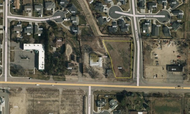
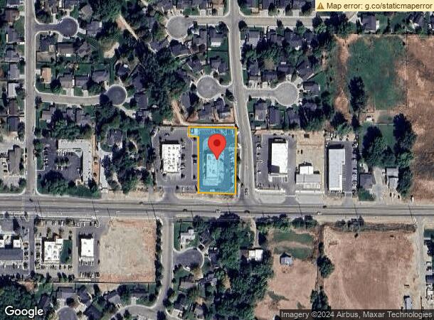
10474 W State St, Star, ID 83669

NEARBY LISTINGS FOR SALE OR LEASE
Property Detail
10474 W State St
S0408347028
PAR #7030 SE4 SW4 SEC 08 4N 1W #347053B 347077B 347028B ROS 13277 PARCEL B
Commercialbuilding
Ada
X
Idaho
16001C0130J
0.93 AC
2024
Star
2025
Boise City/Nampa
010227
Boise City, ID
4,268 SF
DEMOGRAPHICS near 10474 W State St
1 mile
3 mile
5 mile
2024 Total Population
7,874
22,198
59,994
2029 Population
9,024
25,809
69,476
Pop Growth 2024-2029
+ 14.61%
+ 16.27%
+ 15.80%
Average Age
42
42
40
2024 Total Households
2,856
7,784
19,954
HH Growth 2024-2029
+ 14.88%
+ 16.50%
+ 16.18%
Median Household Inc
$75,632
$90,090
$99,547
Avg Household Size
2.70
2.80
3.00
2024 Avg HH Vehicles
2.00
2.00
2.00
Median Home Value
$562,098
$655,779
$627,241
Median Year Built
2010
2010
2010
Nearby Places
Map Layers
Map Styles
 Street
 Aerial
Transit
 Traffic
 Biking
Places
Listings with unknown addresses are not visible on the map
- Restaurants
- Banks
- Shops
- Fitness
- Groceries
PUBLIC TRANSPORTATION
AIRPORT
Boise Air Trml/Gowen Field
Drive
Walk
Distance
Boise Air Trml/Gowen Field
35 min
22.7 mi
SALE & LEASE HISTORY
LISTING DATE
SALE/LEASE

Sep 24, 2016
For Sale
Nearby Properties
Address
Land Use
TOTAL SIZE
Lot Size
Zoning
Address
Land Use
TOTAL SIZE
Lot Size
Zoning
27,975 SF
40.88 AC
Address
Land Use
TOTAL SIZE
Lot Size
Zoning
17.46 AC
R-15
Address
Land Use
TOTAL SIZE
Lot Size
Zoning
15.16 AC
R-14-DA
Address
Land Use
TOTAL SIZE
Lot Size
Zoning
178,710 SF
13.47 AC
R-13
Address
Land Use
TOTAL SIZE
Lot Size
Zoning
227,392 SF
4.40 AC
L-O
Address
Land Use
TOTAL SIZE
Lot Size
Zoning
96,860 SF
12.62 AC
LI-DA
Address
Land Use
TOTAL SIZE
Lot Size
Zoning
174,428 SF
10 AC
MU
Address
Land Use
TOTAL SIZE
Lot Size
Zoning
246,075 SF
11.16 AC
C-2
Address
Land Use
TOTAL SIZE
Lot Size
Zoning
56,420 SF
10.27 AC
M1
Address
Land Use
TOTAL SIZE
Lot Size
Zoning
714 SF
59.61 AC
R-5-DA
Address
Land Use
TOTAL SIZE
Lot Size
Zoning
20,595 SF
2.32 AC
MU
Address
Land Use
TOTAL SIZE
Lot Size
Zoning
63,346 SF
6.87 AC
C-2
Address
Land Use
TOTAL SIZE
Lot Size
Zoning
132,187 SF
7.47 AC
MU
Address
Land Use
TOTAL SIZE
Lot Size
Zoning
89.84 AC
R-4-DA
Address
Land Use
TOTAL SIZE
Lot Size
Zoning
58,697 SF
4.86 AC
CBD-DA
Address
Land Use
TOTAL SIZE
Lot Size
Zoning
34,510 SF
3.20 AC
C-2
Address
Land Use
TOTAL SIZE
Lot Size
Zoning
1,791 SF
40 AC
R-4-DA
Address
Land Use
TOTAL SIZE
Lot Size
Zoning
12.14 AC
C-G
Address
Land Use
TOTAL SIZE
Lot Size
Zoning
6,683 SF
9.62 AC
C-1-DA
Address
Land Use
TOTAL SIZE
Lot Size
Zoning
11,497 SF
4.35 AC
RUT
Address
Land Use
TOTAL SIZE
Lot Size
Zoning
11,022 SF
0.92 AC
RUT
Address
Land Use
TOTAL SIZE
Lot Size
Zoning
52.23 AC
R-3
Address
Land Use
TOTAL SIZE
Lot Size
Zoning
11,526 SF
1.35 AC
RUT
Address
Land Use
TOTAL SIZE
Lot Size
Zoning
4,980 SF
26.18 AC
MU-DA
Address
Land Use
TOTAL SIZE
Lot Size
Zoning
8,883 SF
5 AC
RUT
Address
Land Use
TOTAL SIZE
Lot Size
Zoning
10,180 SF
1.21 AC
RUT
Address
Land Use
TOTAL SIZE
Lot Size
Zoning
38.99 AC
R-3-DA
Address
Land Use
TOTAL SIZE
Lot Size
Zoning
12,437 SF
5.97 AC
R-R-DA
Address
Land Use
TOTAL SIZE
Lot Size
Zoning
16,353 SF
17.12 AC
Address
Land Use
TOTAL SIZE
Lot Size
Zoning
10,253 SF
1.31 AC
RUT
The World's #1 Commercial Real Estate Marketplace
Connect with us
© 2026 CoStar Group
The information above has been obtained from sources believed reliable. While we do not doubt its accuracy we have not verified it and make no guarantee, warranty or representation about it. It is your responsibility to independently confirm its accuracy and completeness. Any projections, opinions, assumptions, or estimates used are for example only and do not represent the current or future performance of the property. The value of this transaction to you depends on tax and other factors which should be evaluated by your tax, financial, and legal advisors. You and your advisors should conduct a careful, independent investigation of the property to determine to your satisfaction the suitability of the property for your needs.