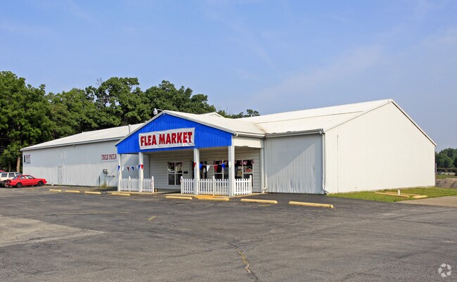
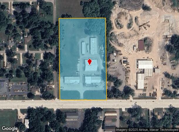
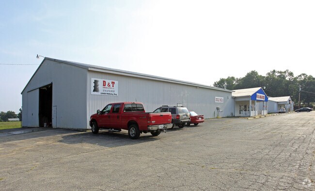
Property Record
10433 Mckinley Hwy, Osceola, IN 46561
NEARBY LISTINGS FOR SALE OR LEASE
Property Detail
10433 Mckinley Hwy
South Bend-Mishawaka, IN-MI
Apple Road Minor Sub
71-10-04-251-002.000-031
LOT 2 APPLE ROAD MINOR SUB EX PTS SOLD FOR STREET 16/17 SPLIT#2676 04-24-2015
Storebuilding
St Joseph
X
Indiana
18039C0125D
2
2023
8.61 AC
2024
Outlying St Joseph County
011603
South Bend/Mishawaka
33,128 SF
DEMOGRAPHICS near 10433 Mckinley Hwy
1 Mile
3 Mile
5 Mile
2024 Total Population
4,578
29,297
75,805
2029 Population
4,513
29,037
75,392
Pop Growth 2024-2029
(1.42%)
(0.89%)
(0.54%)
Average Age
39
39
39
2024 Total Households
1,646
10,741
28,085
HH Growth 2024-2029
(1.46%)
(0.98%)
(0.62%)
Median Household Inc
$81,353
$73,523
$66,645
Avg Household Size
2.70
2.70
2.60
2024 Avg HH Vehicles
2.00
2.00
2.00
Median Home Value
$172,688
$179,278
$179,188
Median Year Built
1979
1977
1974
Nearby Places
- Restaurants
- Banks
- Shops
- Fitness
- Groceries
PUBLIC TRANSPORTATION
COMMUTER RAIL
DRIVE
WALK
Distance
10 min
5.6 mi
AIRPORT
South Bend International
DRIVE
WALK
Distance
South Bend International
34 min
15.6 mi
SALE & LEASE HISTORY
LISTING DATE
SALE/LEASE

May 27, 2023
For Lease
Nearby Properties
Address
Land Use
TOTAL SIZE
Lot Size
Zoning
Address
Land Use
TOTAL SIZE
Lot Size
Zoning
2,584,820 SF
32.18 AC
Address
Land Use
TOTAL SIZE
Lot Size
Zoning
377,169 SF
23.85 AC
ZO01
Address
Land Use
TOTAL SIZE
Lot Size
Zoning
184,212 SF
23.71 AC
ZO01
Address
Land Use
TOTAL SIZE
Lot Size
Zoning
36,851 SF
22.72 AC
Address
Land Use
TOTAL SIZE
Lot Size
Zoning
83,856 SF
54.56 AC
ZO01
Address
Land Use
TOTAL SIZE
Lot Size
Zoning
3,692,640 SF
0.01 AC
Address
Land Use
TOTAL SIZE
Lot Size
Zoning
316,658 SF
27.46 AC
Address
Land Use
TOTAL SIZE
Lot Size
Zoning
144,550 SF
30.99 AC
ZO01
Address
Land Use
TOTAL SIZE
Lot Size
Zoning
188,176 SF
13.90 AC
ZO01
Address
Land Use
TOTAL SIZE
Lot Size
Zoning
51,620 SF
30.21 AC
ZO01
Address
Land Use
TOTAL SIZE
Lot Size
Zoning
123,595 SF
7.92 AC
Address
Land Use
TOTAL SIZE
Lot Size
Zoning
115,990 SF
11.91 AC
Address
Land Use
TOTAL SIZE
Lot Size
Zoning
81,185 SF
23.42 AC
Address
Land Use
TOTAL SIZE
Lot Size
Zoning
159,677 SF
6.67 AC
Address
Land Use
TOTAL SIZE
Lot Size
Zoning
225,200 SF
25.73 AC
Address
Land Use
TOTAL SIZE
Lot Size
Zoning
182,018 SF
30.91 AC
ZO01
Address
Land Use
TOTAL SIZE
Lot Size
Zoning
136,400 SF
6.48 AC
M-1
Address
Land Use
TOTAL SIZE
Lot Size
Zoning
46,080 SF
2.64 AC
Address
Land Use
TOTAL SIZE
Lot Size
Zoning
49,293 SF
87 SF
Address
Land Use
TOTAL SIZE
Lot Size
Zoning
50,250 SF
16.70 AC
ZO01
Address
Land Use
TOTAL SIZE
Lot Size
Zoning
0.02 AC
Address
Land Use
TOTAL SIZE
Lot Size
Zoning
30,470 SF
20 AC
Address
Land Use
TOTAL SIZE
Lot Size
Zoning
47,240 SF
6.66 AC
Address
Land Use
TOTAL SIZE
Lot Size
Zoning
281,499 SF
21.32 AC
Address
Land Use
TOTAL SIZE
Lot Size
Zoning
42,500 SF
1.93 AC
Address
Land Use
TOTAL SIZE
Lot Size
Zoning
69,518 SF
33.38 AC
ZO01
Address
Land Use
TOTAL SIZE
Lot Size
Zoning
29,045 SF
8.25 AC
Address
Land Use
TOTAL SIZE
Lot Size
Zoning
55,428 SF
44 SF
Address
Land Use
TOTAL SIZE
Lot Size
Zoning
50,057 SF
10 AC
ZO01
Address
Land Use
TOTAL SIZE
Lot Size
Zoning
30,344 SF
7.94 AC
The World's #1 Commercial Real Estate Marketplace
Connect with us
© 2025 CoStar Group
The information above has been obtained from sources believed reliable. While we do not doubt its accuracy we have not verified it and make no guarantee, warranty or representation about it. It is your responsibility to independently confirm its accuracy and completeness. Any projections, opinions, assumptions, or estimates used are for example only and do not represent the current or future performance of the property. The value of this transaction to you depends on tax and other factors which should be evaluated by your tax, financial, and legal advisors. You and your advisors should conduct a careful, independent investigation of the property to determine to your satisfaction the suitability of the property for your needs.