Property Record
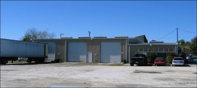
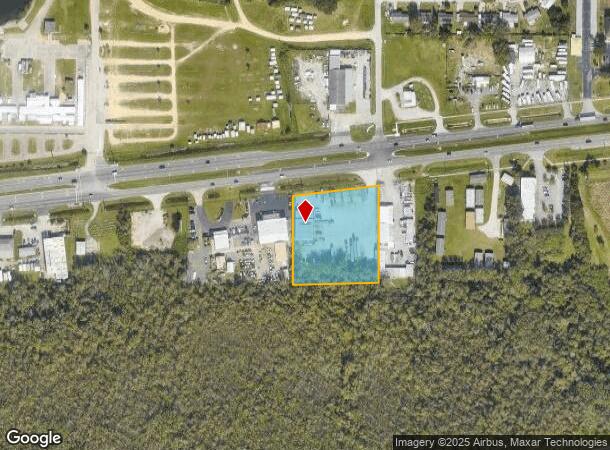
1048 1/2 Us Highway 92 W, Auburndale, FL 33823
NEARBY LISTINGS FOR SALE OR LEASE
Property Detail
1048 1/2 Us Highway 92 W
25-28-09-000000-044140
Hilltop
Storebuilding
BEG 359PT78 FT E OF SW COR OF SW1/4 RUN NLY TO S BDRY OF R/W OF ST RD 600 ELY ALONG R/W 300 FT S TO S SEC LINE W 298 FT TO BEG LESS HWY R/W
X
Polk
12105C0340G
Florida
2024
2.18 AC
2025
Polk County
011721
Tampa/St Petersburg
6,000 SF
Lakeland-Winter Haven, FL
DEMOGRAPHICS near 1048 1/2 Us Highway 92 W
1 Mile
3 Mile
5 Mile
2024 Total Population
2,482
24,170
75,784
2029 Population
2,958
29,063
91,501
Pop Growth 2024-2029
+ 19.18%
+ 20.24%
+ 20.74%
Average Age
37
43
41
2024 Total Households
934
9,585
28,959
HH Growth 2024-2029
+ 19.06%
+ 20.27%
+ 20.71%
Median Household Inc
$39,595
$53,729
$54,089
Avg Household Size
2.60
2.50
2.60
2024 Avg HH Vehicles
2.00
2.00
2.00
Median Home Value
$159,321
$133,403
$167,661
Median Year Built
1978
1985
1983
Nearby Places
Map Layers
Map Styles
 Street
 Aerial
- Restaurants
- Banks
- Shops
- Fitness
- Groceries
PUBLIC TRANSPORTATION
COMMUTER RAIL
DRIVE
WALK
Distance
14 min
7.9 mi
DRIVE
WALK
Distance
14 min
8.3 mi
AIRPORT
Orlando International
DRIVE
WALK
Distance
Orlando International
63 min
50.0 mi
Freight Ports
Port of Tampa Bay
DRIVE
WALK
Distance
Port of Tampa Bay
59 min
42.3 mi
Nearby Properties
Address
Land Use
TOTAL SIZE
Lot Size
Zoning
Address
Land Use
TOTAL SIZE
Lot Size
Zoning
831,600 SF
51.22 AC
Address
Land Use
TOTAL SIZE
Lot Size
Zoning
811,392 SF
47.70 AC
Address
Land Use
TOTAL SIZE
Lot Size
Zoning
942,646 SF
91.30 AC
R3
Address
Land Use
TOTAL SIZE
Lot Size
Zoning
275,220 SF
94.53 AC
Address
Land Use
TOTAL SIZE
Lot Size
Zoning
238,721 SF
11.66 AC
GI
Address
Land Use
TOTAL SIZE
Lot Size
Zoning
202,567 SF
189.02 AC
RE1
Address
Land Use
TOTAL SIZE
Lot Size
Zoning
110,108 SF
10 AC
Address
Land Use
TOTAL SIZE
Lot Size
Zoning
136,724 SF
4.62 AC
GI
Address
Land Use
TOTAL SIZE
Lot Size
Zoning
108,360 SF
4.23 AC
GI
Address
Land Use
TOTAL SIZE
Lot Size
Zoning
188,553 SF
29.12 AC
Address
Land Use
TOTAL SIZE
Lot Size
Zoning
178,899 SF
10.09 AC
GI
Address
Land Use
TOTAL SIZE
Lot Size
Zoning
241,319 SF
5.67 AC
Address
Land Use
TOTAL SIZE
Lot Size
Zoning
291,428 SF
59.34 AC
Address
Land Use
TOTAL SIZE
Lot Size
Zoning
129,567 SF
11.72 AC
C3
Address
Land Use
TOTAL SIZE
Lot Size
Zoning
135,247 SF
22.49 AC
C4
Address
Land Use
TOTAL SIZE
Lot Size
Zoning
91,962 SF
19.46 AC
R4
Address
Land Use
TOTAL SIZE
Lot Size
Zoning
191,975 SF
14.28 AC
HI
Address
Land Use
TOTAL SIZE
Lot Size
Zoning
174,108 SF
4.82 AC
Address
Land Use
TOTAL SIZE
Lot Size
Zoning
126,384 SF
4.67 AC
CH
Address
Land Use
TOTAL SIZE
Lot Size
Zoning
320,765 SF
14.93 AC
GI
Address
Land Use
TOTAL SIZE
Lot Size
Zoning
268,800 SF
9.22 AC
Address
Land Use
TOTAL SIZE
Lot Size
Zoning
42,400 SF
121.06 AC
RC
Address
Land Use
TOTAL SIZE
Lot Size
Zoning
243,600 SF
35.47 AC
C4
Address
Land Use
TOTAL SIZE
Lot Size
Zoning
309,124 SF
31.33 AC
XX
Address
Land Use
TOTAL SIZE
Lot Size
Zoning
80,280 SF
25.05 AC
Address
Land Use
TOTAL SIZE
Lot Size
Zoning
122,260 SF
4.77 AC
Address
Land Use
TOTAL SIZE
Lot Size
Zoning
90,077 SF
12.41 AC
Address
Land Use
TOTAL SIZE
Lot Size
Zoning
69,835 SF
7.06 AC
CH
Address
Land Use
TOTAL SIZE
Lot Size
Zoning
80,100 SF
4.68 AC
GI
Address
Land Use
TOTAL SIZE
Lot Size
Zoning
30,638 SF
4.22 AC
R3
The World's #1 Commercial Real Estate Marketplace
Connect with us
© 2025 CoStar Group
The information above has been obtained from sources believed reliable. While we do not doubt its accuracy we have not verified it and make no guarantee, warranty or representation about it. It is your responsibility to independently confirm its accuracy and completeness. Any projections, opinions, assumptions, or estimates used are for example only and do not represent the current or future performance of the property. The value of this transaction to you depends on tax and other factors which should be evaluated by your tax, financial, and legal advisors. You and your advisors should conduct a careful, independent investigation of the property to determine to your satisfaction the suitability of the property for your needs.