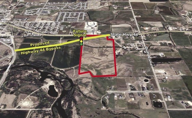
Property Record
10481 Highway 44, Middleton, ID 83644

NEARBY LISTINGS FOR SALE OR LEASE
Property Detail
10481 Highway 44
Boise City, ID
08-4N-2W NE TX 06320 IN SWNE & IN GOVT LT 2 LS TX 22639 & RD & SUBS
3392000000
Canyon
Industrialacreage
Idaho
AE
2
16001C0125J
44 AC
2024
Middleton
2025
Boise City/Nampa
021901
DEMOGRAPHICS near 10481 Highway 44
1 Mile
3 Mile
5 Mile
2024 Total Population
4,048
19,779
55,769
2029 Population
4,936
24,341
68,177
Pop Growth 2024-2029
+ 21.94%
+ 23.06%
+ 22.25%
Average Age
36
37
36
2024 Total Households
1,343
6,380
17,816
HH Growth 2024-2029
+ 22.26%
+ 23.34%
+ 22.52%
Median Household Inc
$58,714
$72,334
$70,954
Avg Household Size
3.00
3.10
3.10
2024 Avg HH Vehicles
3.00
3.00
2.00
Median Home Value
$347,868
$371,385
$366,300
Median Year Built
2002
2005
2003
Nearby Places
Map Layers
Map Styles
 Street
 Aerial
- Restaurants
- Banks
- Shops
- Fitness
- Groceries
PUBLIC TRANSPORTATION
AIRPORT
Boise Air Trml/Gowen Field
DRIVE
WALK
Distance
Boise Air Trml/Gowen Field
55 min
30.9 mi
Freight Ports
Port of Portland
DRIVE
WALK
Distance
Port of Portland
452 min
408.6 mi
SALE & LEASE HISTORY
LISTING DATE
SALE/LEASE

Sep 24, 2016
For Sale
Jan 24, 2024
For Sale
Jan 13, 2023
For Lease
Jan 13, 2023
For Sale
Nearby Properties
Address
Land Use
TOTAL SIZE
Lot Size
Zoning
Address
Land Use
TOTAL SIZE
Lot Size
Zoning
15,490 SF
47.33 AC
M1
Address
Land Use
TOTAL SIZE
Lot Size
Zoning
55,920 SF
7.47 AC
M1
Address
Land Use
TOTAL SIZE
Lot Size
Zoning
9.55 AC
Address
Land Use
TOTAL SIZE
Lot Size
Zoning
20.18 AC
Address
Land Use
TOTAL SIZE
Lot Size
Zoning
4.93 AC
Address
Land Use
TOTAL SIZE
Lot Size
Zoning
4.47 AC
Address
Land Use
TOTAL SIZE
Lot Size
Zoning
15.69 AC
M1
Address
Land Use
TOTAL SIZE
Lot Size
Zoning
4.89 AC
M1
Address
Land Use
TOTAL SIZE
Lot Size
Zoning
48,600 SF
2.17 AC
M1
Address
Land Use
TOTAL SIZE
Lot Size
Zoning
13.44 AC
Address
Land Use
TOTAL SIZE
Lot Size
Zoning
1.08 AC
M1
Address
Land Use
TOTAL SIZE
Lot Size
Zoning
1,368 SF
4.73 AC
Address
Land Use
TOTAL SIZE
Lot Size
Zoning
2.36 AC
M1
Address
Land Use
TOTAL SIZE
Lot Size
Zoning
62,950 SF
8.40 AC
M1
Address
Land Use
TOTAL SIZE
Lot Size
Zoning
3.76 AC
Address
Land Use
TOTAL SIZE
Lot Size
Zoning
23.41 AC
C1
Address
Land Use
TOTAL SIZE
Lot Size
Zoning
Address
Land Use
TOTAL SIZE
Lot Size
Zoning
2.79 AC
Address
Land Use
TOTAL SIZE
Lot Size
Zoning
5.96 AC
Address
Land Use
TOTAL SIZE
Lot Size
Zoning
34,130 SF
5.28 AC
M1
Address
Land Use
TOTAL SIZE
Lot Size
Zoning
49.11 AC
C1
Address
Land Use
TOTAL SIZE
Lot Size
Zoning
57.19 AC
Address
Land Use
TOTAL SIZE
Lot Size
Zoning
1,641 SF
20.32 AC
Address
Land Use
TOTAL SIZE
Lot Size
Zoning
21.43 AC
Address
Land Use
TOTAL SIZE
Lot Size
Zoning
1.06 AC
C1
Address
Land Use
TOTAL SIZE
Lot Size
Zoning
2.07 AC
M1
Address
Land Use
TOTAL SIZE
Lot Size
Zoning
15.58 AC
Address
Land Use
TOTAL SIZE
Lot Size
Zoning
1.31 AC
Address
Land Use
TOTAL SIZE
Lot Size
Zoning
2.23 AC
Address
Land Use
TOTAL SIZE
Lot Size
Zoning
1,745 SF
51.42 AC
The World's #1 Commercial Real Estate Marketplace
Connect with us
© 2025 CoStar Group
The information above has been obtained from sources believed reliable. While we do not doubt its accuracy we have not verified it and make no guarantee, warranty or representation about it. It is your responsibility to independently confirm its accuracy and completeness. Any projections, opinions, assumptions, or estimates used are for example only and do not represent the current or future performance of the property. The value of this transaction to you depends on tax and other factors which should be evaluated by your tax, financial, and legal advisors. You and your advisors should conduct a careful, independent investigation of the property to determine to your satisfaction the suitability of the property for your needs.