Property Record
10489 State Road 27, Hayward, WI 54843


NEARBY LISTINGS FOR SALE OR LEASE
-
-
View all Hayward listings for sale on LoopNet.com
Property Detail
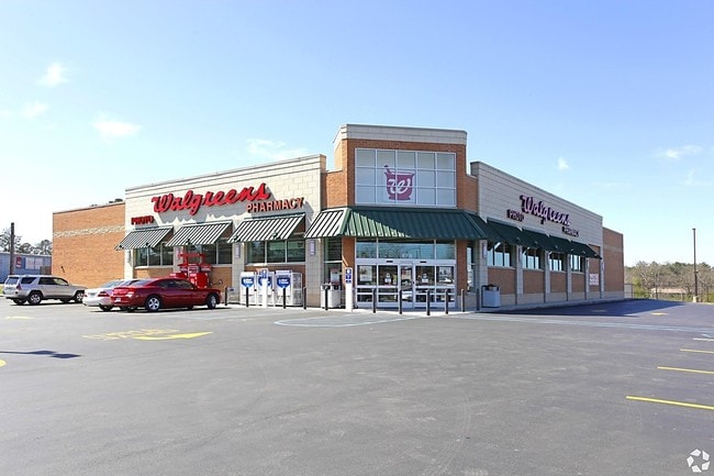
10489 State Road 27
Other Market Areas
PRT NWNW
57-236-2-41-09-27-2 02-000-000260
Sawyer
Commercialnec
Wisconsin
2024
2.23 AC
2024
Wisconsin North Area
100300
DEMOGRAPHICS near 10489 State Road 27
1 Mile
3 Mile
5 Mile
2024 Total Population
1,606
3,490
5,145
2029 Population
1,609
3,503
5,237
Pop Growth 2024-2029
+ 0.19%
+ 0.37%
+ 1.79%
Average Age
42
43
44
2024 Total Households
689
1,496
2,221
HH Growth 2024-2029
(0.15%)
+ 0.13%
+ 1.58%
Median Household Inc
$36,602
$48,749
$52,719
Avg Household Size
2.20
2.20
2.20
2024 Avg HH Vehicles
2.00
2.00
2.00
Median Home Value
$168,811
$178,403
$188,282
Median Year Built
1978
1977
1980
Nearby Places
Map Layers
Map Styles
 Street
 Aerial
- Restaurants
- Banks
- Shops
- Fitness
- Groceries
SALE & LEASE HISTORY
LISTING DATE
SALE/LEASE

Jul 14, 2023
For Sale
Apr 06, 2017
For Sale
Nearby Properties
Address
Land Use
TOTAL SIZE
Lot Size
Zoning
Address
Land Use
TOTAL SIZE
Lot Size
Zoning
17.10 AC
CIT
Address
Land Use
TOTAL SIZE
Lot Size
Zoning
Address
Land Use
TOTAL SIZE
Lot Size
Zoning
91.41 AC
I-1
Address
Land Use
TOTAL SIZE
Lot Size
Zoning
40 AC
I-1
Address
Land Use
TOTAL SIZE
Lot Size
Zoning
8.48 AC
CIT
Address
Land Use
TOTAL SIZE
Lot Size
Zoning
8.28 AC
CIT
Address
Land Use
TOTAL SIZE
Lot Size
Zoning
18.68 AC
CIT
Address
Land Use
TOTAL SIZE
Lot Size
Zoning
389.02 AC
A-1;F-1
Address
Land Use
TOTAL SIZE
Lot Size
Zoning
5.98 AC
CIT
Address
Land Use
TOTAL SIZE
Lot Size
Zoning
2.85 AC
CIT
Address
Land Use
TOTAL SIZE
Lot Size
Zoning
5.25 AC
CIT
Address
Land Use
TOTAL SIZE
Lot Size
Zoning
2.59 AC
CIT
Address
Land Use
TOTAL SIZE
Lot Size
Zoning
2.07 AC
CIT
Address
Land Use
TOTAL SIZE
Lot Size
Zoning
1.43 AC
CIT
Address
Land Use
TOTAL SIZE
Lot Size
Zoning
1.81 AC
CIT
Address
Land Use
TOTAL SIZE
Lot Size
Zoning
20 AC
I-1
Address
Land Use
TOTAL SIZE
Lot Size
Zoning
0.85 AC
CIT
Address
Land Use
TOTAL SIZE
Lot Size
Zoning
1.98 AC
CIT
Address
Land Use
TOTAL SIZE
Lot Size
Zoning
2.68 AC
CIT
Address
Land Use
TOTAL SIZE
Lot Size
Zoning
4.34 AC
CIT
Address
Land Use
TOTAL SIZE
Lot Size
Zoning
4.76 AC
Address
Land Use
TOTAL SIZE
Lot Size
Zoning
11.60 AC
C-1
Address
Land Use
TOTAL SIZE
Lot Size
Zoning
1.41 AC
Address
Land Use
TOTAL SIZE
Lot Size
Zoning
Address
Land Use
TOTAL SIZE
Lot Size
Zoning
0.32 AC
CIT
Address
Land Use
TOTAL SIZE
Lot Size
Zoning
0.40 AC
CIT
Address
Land Use
TOTAL SIZE
Lot Size
Zoning
2.27 AC
CIT
Address
Land Use
TOTAL SIZE
Lot Size
Zoning
0.86 AC
CIT
Address
Land Use
TOTAL SIZE
Lot Size
Zoning
1.58 AC
The World's #1 Commercial Real Estate Marketplace
Connect with us
© 2026 CoStar Group
The information above has been obtained from sources believed reliable. While we do not doubt its accuracy we have not verified it and make no guarantee, warranty or representation about it. It is your responsibility to independently confirm its accuracy and completeness. Any projections, opinions, assumptions, or estimates used are for example only and do not represent the current or future performance of the property. The value of this transaction to you depends on tax and other factors which should be evaluated by your tax, financial, and legal advisors. You and your advisors should conduct a careful, independent investigation of the property to determine to your satisfaction the suitability of the property for your needs.