Property Record
10489 W Lake Hazel Rd, Boise, ID 83709
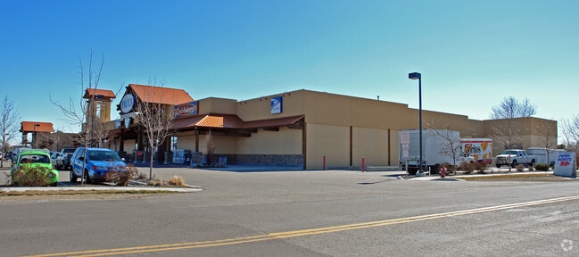

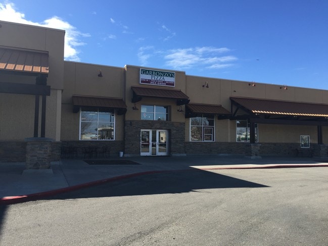
Property Detail
10489 W Lake Hazel Rd
R7620760500
LOT 5 BLK 1 RUNNING SPRINGS SUB
Commercialnec
ADA
C2
Idaho
B and X Area of moderate flood hazard, usually the area between the limits of the 100-year and 500-year floods.
5
2024
2.36 AC
2025
Southwest Boise
010410
Boise City/Nampa
20,484 SF
Boise City, ID
NEARBY LISTINGS FOR SALE OR LEASE
-
-
View all Boise listings for lease on LoopNet.com
DEMOGRAPHICS near 10489 W Lake Hazel Rd
1 mile
3 mile
5 mile
2025 Total Population
14,428
54,363
120,669
2030 Population
15,131
57,131
126,991
Pop Growth 2025-2030
+ 4.87%
+ 5.09%
+ 5.24%
Average Age
37
39
40
2025 Total Households
4,952
18,732
42,962
HH Growth 2025-2030
+ 5.27%
+ 5.42%
+ 5.65%
Median Household Inc
$87,402
$105,036
$95,792
Avg Household Size
2.90
2.90
2.70
2025 Avg HH Vehicles
2.00
2.00
2.00
Median Home Value
$457,830
$498,119
$497,982
Median Year Built
2007
2005
2001
Nearby Places
Map Layers
Map Styles
 Street
 Aerial
Layers
 Traffic
 Biking
Places
Listings with unknown addresses are not visible on the map
- Restaurants
- Banks
- Shops
- Fitness
- Groceries
PUBLIC TRANSPORTATION
AIRPORT
Boise Air Trml/Gowen Field
Drive
Walk
Distance
Boise Air Trml/Gowen Field
15 min
6.1 mi
SALE & LEASE HISTORY
LISTING DATE
SALE/LEASE

Apr 05, 2018
For Lease
Nearby Properties
Address
Land Use
TOTAL SIZE
Lot Size
Zoning
Address
Land Use
TOTAL SIZE
Lot Size
Zoning
164,981 SF
7.47 AC
R20
Address
Land Use
TOTAL SIZE
Lot Size
Zoning
69,620 SF
6.22 AC
M-1D
Address
Land Use
TOTAL SIZE
Lot Size
Zoning
31,460 SF
12.64 AC
ZC-269
Address
Land Use
TOTAL SIZE
Lot Size
Zoning
87,080 SF
2.77 AC
R-15
Address
Land Use
TOTAL SIZE
Lot Size
Zoning
70.14 AC
SP-03
Address
Land Use
TOTAL SIZE
Lot Size
Zoning
58,142 SF
6.48 AC
C-C
Address
Land Use
TOTAL SIZE
Lot Size
Zoning
15 AC
R-3D/DA
Address
Land Use
TOTAL SIZE
Lot Size
Zoning
121,203 SF
5.56 AC
LO
Address
Land Use
TOTAL SIZE
Lot Size
Zoning
54,000 SF
3.23 AC
M-1D
Address
Land Use
TOTAL SIZE
Lot Size
Zoning
16,268 SF
2.27 AC
C-N
Address
Land Use
TOTAL SIZE
Lot Size
Zoning
72,744 SF
3.86 AC
C-C
Address
Land Use
TOTAL SIZE
Lot Size
Zoning
17,175 SF
2.96 AC
C1
Address
Land Use
TOTAL SIZE
Lot Size
Zoning
32,324 SF
6.37 AC
M-1D
Address
Land Use
TOTAL SIZE
Lot Size
Zoning
38,637 SF
0.77 AC
M-1D
Address
Land Use
TOTAL SIZE
Lot Size
Zoning
9.87 AC
R-8
Address
Land Use
TOTAL SIZE
Lot Size
Zoning
5,517 SF
2.72 AC
C-1D
Address
Land Use
TOTAL SIZE
Lot Size
Zoning
14,739 SF
1.74 AC
C2
Address
Land Use
TOTAL SIZE
Lot Size
Zoning
13.33 AC
R-1B
Address
Land Use
TOTAL SIZE
Lot Size
Zoning
15,290 SF
0.56 AC
C2
Address
Land Use
TOTAL SIZE
Lot Size
Zoning
42,680 SF
3.46 AC
C2
Address
Land Use
TOTAL SIZE
Lot Size
Zoning
37,587 SF
1.60 AC
M-1D
Address
Land Use
TOTAL SIZE
Lot Size
Zoning
32,942 SF
2.49 AC
M-1D
Address
Land Use
TOTAL SIZE
Lot Size
Zoning
32,942 SF
2.48 AC
M-1D
Address
Land Use
TOTAL SIZE
Lot Size
Zoning
40.19 AC
R-6
Address
Land Use
TOTAL SIZE
Lot Size
Zoning
5,148 SF
1.48 AC
C2
Address
Land Use
TOTAL SIZE
Lot Size
Zoning
48,905 SF
4.55 AC
R-8
Address
Land Use
TOTAL SIZE
Lot Size
Zoning
11,331 SF
1.51 AC
C-N
Address
Land Use
TOTAL SIZE
Lot Size
Zoning
32,942 SF
2.69 AC
M-1D
Address
Land Use
TOTAL SIZE
Lot Size
Zoning
32,942 SF
2.71 AC
M-1D
Address
Land Use
TOTAL SIZE
Lot Size
Zoning
29,620 SF
2.13 AC
M-1D
The World's #1 Commercial Real Estate Marketplace
Connect with us
© 2026 CoStar Group
The information above has been obtained from sources believed reliable. While we do not doubt its accuracy we have not verified it and make no guarantee, warranty or representation about it. It is your responsibility to independently confirm its accuracy and completeness. Any projections, opinions, assumptions, or estimates used are for example only and do not represent the current or future performance of the property. The value of this transaction to you depends on tax and other factors which should be evaluated by your tax, financial, and legal advisors. You and your advisors should conduct a careful, independent investigation of the property to determine to your satisfaction the suitability of the property for your needs.