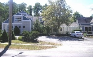
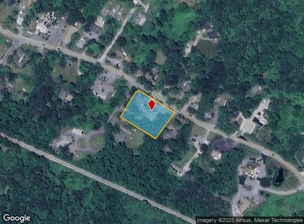
Property Record
1049 Main St, West Barnstable, MA 02668
Current Lease Availabilities
NEARBY LISTINGS FOR SALE OR LEASE
-
-
View all West Barnstable listings for lease on LoopNet.com
Property Detail
1049 Main St
BARN-000178-000000-000030
Barnstable
Officebuilding
Massachusetts
X
30
25001C0553J
1.09 AC
2025
Cape Cod
2025
Other Market Areas
012200
Barnstable Town, MA
6,684 SF
DEMOGRAPHICS near 1049 Main St
1 mile
3 mile
5 mile
2024 Total Population
437
9,956
37,482
2029 Population
430
9,873
37,702
Pop Growth 2024-2029
(1.60%)
(0.83%)
+ 0.59%
Average Age
48
47
47
2024 Total Households
172
4,024
15,196
HH Growth 2024-2029
(1.74%)
(1.17%)
+ 0.39%
Median Household Inc
$111,397
$114,456
$95,852
Avg Household Size
2.30
2.40
2.40
2024 Avg HH Vehicles
2.00
2.00
2.00
Median Home Value
$626,237
$479,908
$475,149
Median Year Built
1985
1981
1979
Nearby Places
Map Layers
Map Styles
 Street
 Aerial
Transit
 Traffic
 Biking
Places
Listings with unknown addresses are not visible on the map
- Restaurants
- Banks
- Shops
- Fitness
- Groceries
PUBLIC TRANSPORTATION
COMMUTER RAIL
Drive
Walk
Distance
12 min
6.0 mi
AIRPORT
Martha's Vineyard
Drive
Walk
Distance
Martha's Vineyard
101 min
36.9 mi
Freight Ports
Port of New Bedford Harbor
Drive
Walk
Distance
Port of New Bedford Harbor
59 min
42.9 mi
Nearby Properties
Address
Land Use
TOTAL SIZE
Lot Size
Zoning
Address
Land Use
TOTAL SIZE
Lot Size
Zoning
44 AC
RG;RF
Address
Land Use
TOTAL SIZE
Lot Size
Zoning
1,114.30 AC
Address
Land Use
TOTAL SIZE
Lot Size
Zoning
36,536 SF
36.91 AC
RG;RF-
Address
Land Use
TOTAL SIZE
Lot Size
Zoning
39,689 SF
9.12 AC
Address
Land Use
TOTAL SIZE
Lot Size
Zoning
9,038 SF
2.20 AC
R-2
Address
Land Use
TOTAL SIZE
Lot Size
Zoning
126.31 AC
RG;RF-
Address
Land Use
TOTAL SIZE
Lot Size
Zoning
5,554 SF
2.70 AC
R-2
Address
Land Use
TOTAL SIZE
Lot Size
Zoning
9,104 SF
2.40 AC
R-2
Address
Land Use
TOTAL SIZE
Lot Size
Zoning
1,188.31 AC
RF;RF-
Address
Land Use
TOTAL SIZE
Lot Size
Zoning
6,582 SF
30.69 AC
RC
Address
Land Use
TOTAL SIZE
Lot Size
Zoning
143.68 AC
R
Address
Land Use
TOTAL SIZE
Lot Size
Zoning
1.91 AC
RF
Address
Land Use
TOTAL SIZE
Lot Size
Zoning
7,474 SF
3.50 AC
R-2
Address
Land Use
TOTAL SIZE
Lot Size
Zoning
3,690 SF
1.83 AC
1
Address
Land Use
TOTAL SIZE
Lot Size
Zoning
6,730 SF
2.10 AC
R-2
Address
Land Use
TOTAL SIZE
Lot Size
Zoning
4,723 SF
1.29 AC
1
Address
Land Use
TOTAL SIZE
Lot Size
Zoning
5.32 AC
RF
Address
Land Use
TOTAL SIZE
Lot Size
Zoning
5,771 SF
3.06 AC
R
Address
Land Use
TOTAL SIZE
Lot Size
Zoning
5,530 SF
2.40 AC
R-2
Address
Land Use
TOTAL SIZE
Lot Size
Zoning
7.13 AC
1
Address
Land Use
TOTAL SIZE
Lot Size
Zoning
61 AC
1
Address
Land Use
TOTAL SIZE
Lot Size
Zoning
6,209 SF
7.18 AC
R-2
Address
Land Use
TOTAL SIZE
Lot Size
Zoning
3,356 SF
1.30 AC
RF
Address
Land Use
TOTAL SIZE
Lot Size
Zoning
4,888 SF
1.50 AC
R-2
Address
Land Use
TOTAL SIZE
Lot Size
Zoning
7,389 SF
1.10 AC
1
Address
Land Use
TOTAL SIZE
Lot Size
Zoning
3,653 SF
1.86 AC
1
Address
Land Use
TOTAL SIZE
Lot Size
Zoning
2,600 SF
1.44 AC
RF
Address
Land Use
TOTAL SIZE
Lot Size
Zoning
172.75 AC
RG;RF-
Address
Land Use
TOTAL SIZE
Lot Size
Zoning
4,334 SF
2.07 AC
1
Address
Land Use
TOTAL SIZE
Lot Size
Zoning
4,217 SF
1.86 AC
R-2
The World's #1 Commercial Real Estate Marketplace
Connect with us
© 2026 CoStar Group
The information above has been obtained from sources believed reliable. While we do not doubt its accuracy we have not verified it and make no guarantee, warranty or representation about it. It is your responsibility to independently confirm its accuracy and completeness. Any projections, opinions, assumptions, or estimates used are for example only and do not represent the current or future performance of the property. The value of this transaction to you depends on tax and other factors which should be evaluated by your tax, financial, and legal advisors. You and your advisors should conduct a careful, independent investigation of the property to determine to your satisfaction the suitability of the property for your needs.