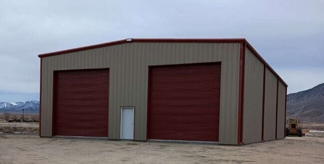
Property Record
105 121St St, Hawthorne, NV 89415

NEARBY LISTINGS FOR SALE OR LEASE
-
-
View all Hawthorne listings for lease on LoopNet.com
Property Detail
105 121St St
006-640-61
General
Lightindustrial
GENERAL
A
Mineral
32021C0995C
Nevada
2024
6.01 AC
2025
Carson City/Nevada Area
970700
Other Market Areas
DEMOGRAPHICS near 105 121St St
1 mile
3 mile
5 mile
2024 Total Population
218
2,967
3,166
2029 Population
218
2,917
3,114
Pop Growth 2024-2029
0.00%
(1.69%)
(1.64%)
Average Age
43
44
44
2024 Total Households
94
1,362
1,451
HH Growth 2024-2029
+ 1.06%
(1.69%)
(1.65%)
Median Household Inc
$51,667
$51,681
$50,424
Avg Household Size
2.20
2.10
2.10
2024 Avg HH Vehicles
2.00
2.00
2.00
Median Home Value
$150,000
$162,923
$153,688
Median Year Built
1966
1969
1970
Nearby Places
Map Layers
Map Styles
 Street
 Aerial
Transit
 Traffic
 Biking
Places
Listings with unknown addresses are not visible on the map
- Restaurants
- Banks
- Shops
- Fitness
- Groceries
SALE & LEASE HISTORY
LISTING DATE
SALE/LEASE

Apr 01, 2024
For Lease
Nearby Properties
Address
Land Use
TOTAL SIZE
Lot Size
Zoning
Address
Land Use
TOTAL SIZE
Lot Size
Zoning
68,761 SF
52.99 AC
P;PUBLIC
Address
Land Use
TOTAL SIZE
Lot Size
Zoning
74,176 SF
0.83 AC
C1;COMMERC
Address
Land Use
TOTAL SIZE
Lot Size
Zoning
42,236 SF
2.30 AC
C1;COMMERC
Address
Land Use
TOTAL SIZE
Lot Size
Zoning
27,300 SF
13 AC
C1;COMMERC
Address
Land Use
TOTAL SIZE
Lot Size
Zoning
7,200 SF
7.14 AC
C1
Address
Land Use
TOTAL SIZE
Lot Size
Zoning
10,411 SF
3.40 AC
P;PUBLIC
Address
Land Use
TOTAL SIZE
Lot Size
Zoning
43.70 AC
M1;INDUSTR
Address
Land Use
TOTAL SIZE
Lot Size
Zoning
13,098 SF
5.93 AC
C1;COMMERC
Address
Land Use
TOTAL SIZE
Lot Size
Zoning
25,488 SF
18.18 AC
P;PUBLIC
Address
Land Use
TOTAL SIZE
Lot Size
Zoning
10,956 SF
2.58 AC
P;PUBLIC
Address
Land Use
TOTAL SIZE
Lot Size
Zoning
20,225 SF
0.68 AC
C1;COMMERC
Address
Land Use
TOTAL SIZE
Lot Size
Zoning
4,790 SF
2 AC
C1;COMMERC
Address
Land Use
TOTAL SIZE
Lot Size
Zoning
16,836 SF
1.84 AC
R3;MULTI F
Address
Land Use
TOTAL SIZE
Lot Size
Zoning
3,275 SF
2 AC
M3;OPEN US
Address
Land Use
TOTAL SIZE
Lot Size
Zoning
26,564 SF
2.40 AC
C1;COMMERC
Address
Land Use
TOTAL SIZE
Lot Size
Zoning
5,742 SF
0.62 AC
C1;COMMERC
Address
Land Use
TOTAL SIZE
Lot Size
Zoning
7,200 SF
Address
Land Use
TOTAL SIZE
Lot Size
Zoning
8,000 SF
0.92 AC
C1;COMMERC
Address
Land Use
TOTAL SIZE
Lot Size
Zoning
9,100 SF
0.97 AC
C1;COMMERC
Address
Land Use
TOTAL SIZE
Lot Size
Zoning
4,438 SF
1.05 AC
R1;SINGLE
Address
Land Use
TOTAL SIZE
Lot Size
Zoning
14,492 SF
1.15 AC
C1;COMMERC
Address
Land Use
TOTAL SIZE
Lot Size
Zoning
13,602 SF
0.92 AC
C1;COMMERC
Address
Land Use
TOTAL SIZE
Lot Size
Zoning
2,304 SF
1.17 AC
C1;COMMERC
Address
Land Use
TOTAL SIZE
Lot Size
Zoning
9,120 SF
0.76 AC
P;PUBLIC
Address
Land Use
TOTAL SIZE
Lot Size
Zoning
11,609 SF
2.50 AC
P;PUBLIC
Address
Land Use
TOTAL SIZE
Lot Size
Zoning
80 AC
Address
Land Use
TOTAL SIZE
Lot Size
Zoning
13,600 SF
0.88 AC
C1;COMMERC
Address
Land Use
TOTAL SIZE
Lot Size
Zoning
4,484 SF
0.10 AC
R2T;LTD MU
Address
Land Use
TOTAL SIZE
Lot Size
Zoning
9,485 SF
24.33 AC
M3
The World's #1 Commercial Real Estate Marketplace
Connect with us
© 2026 CoStar Group
The information above has been obtained from sources believed reliable. While we do not doubt its accuracy we have not verified it and make no guarantee, warranty or representation about it. It is your responsibility to independently confirm its accuracy and completeness. Any projections, opinions, assumptions, or estimates used are for example only and do not represent the current or future performance of the property. The value of this transaction to you depends on tax and other factors which should be evaluated by your tax, financial, and legal advisors. You and your advisors should conduct a careful, independent investigation of the property to determine to your satisfaction the suitability of the property for your needs.