Property Record
105 2Nd St, Isleton, CA 95641

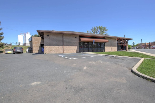

Property Detail
105 2Nd St
Sacramento-Roseville-Folsom, CA
CITY OF ISLETON,, LOT 4, BLOCK:: 12
157-0013-004
SACRAMENTO
Storebuilding
California
CC
4
AE The base floodplain where base flood elevations are provided. AE Zones are now used on new format FIRMs instead of A1-A30 Zones.
0.83 AC
2024
Outer Sacramento Cnty
2025
Sacramento
009800
NEARBY LISTINGS FOR SALE OR LEASE
DEMOGRAPHICS near 105 2Nd St
1 mile
3 mile
5 mile
2025 Total Population
527
1,401
6,832
2030 Population
503
1,350
6,805
Pop Growth 2025-2030
(4.55%)
(3.64%)
(0.40%)
Average Age
46
45
44
2025 Total Households
210
553
2,836
HH Growth 2025-2030
(4.29%)
(3.62%)
(0.49%)
Median Household Inc
$99,218
$96,220
$86,533
Avg Household Size
2.50
2.50
2.40
2025 Avg HH Vehicles
2.00
2.00
2.00
Median Home Value
$397,367
$431,034
$543,575
Median Year Built
1972
1972
1969
Nearby Places
Map Layers
Map Styles
 Street
 Aerial
Layers
 Traffic
 Biking
Places
Listings with unknown addresses are not visible on the map
- Restaurants
- Banks
- Shops
- Fitness
- Groceries
PUBLIC TRANSPORTATION
AIRPORT
Stockton Metro
Drive
Walk
Distance
Stockton Metro
48 min
34.7 mi
Freight Ports
Port of Stockton
Drive
Walk
Distance
Port of Stockton
38 min
27.1 mi
SALE & LEASE HISTORY
LISTING DATE
SALE/LEASE

May 03, 2019
For Sale
Feb 17, 2020
For Sale
Nearby Properties
Address
Land Use
TOTAL SIZE
Lot Size
Zoning
Address
Land Use
TOTAL SIZE
Lot Size
Zoning
153,371 SF
15.46 AC
C-O
Address
Land Use
TOTAL SIZE
Lot Size
Zoning
530.29 AC
AG-80
Address
Land Use
TOTAL SIZE
Lot Size
Zoning
AG80 F
Address
Land Use
TOTAL SIZE
Lot Size
Zoning
4,606 SF
720.08 AC
DW-S AG-80
Address
Land Use
TOTAL SIZE
Lot Size
Zoning
513.57 AC
AG-80
Address
Land Use
TOTAL SIZE
Lot Size
Zoning
Address
Land Use
TOTAL SIZE
Lot Size
Zoning
288.37 AC
AG-80
Address
Land Use
TOTAL SIZE
Lot Size
Zoning
420.96 AC
Address
Land Use
TOTAL SIZE
Lot Size
Zoning
Address
Land Use
TOTAL SIZE
Lot Size
Zoning
804 SF
10.12 AC
Address
Land Use
TOTAL SIZE
Lot Size
Zoning
Address
Land Use
TOTAL SIZE
Lot Size
Zoning
Address
Land Use
TOTAL SIZE
Lot Size
Zoning
109.82 AC
AG-80 DW-S
Address
Land Use
TOTAL SIZE
Lot Size
Zoning
Address
Land Use
TOTAL SIZE
Lot Size
Zoning
249.63 AC
AG-80
Address
Land Use
TOTAL SIZE
Lot Size
Zoning
146 AC
AG-80
Address
Land Use
TOTAL SIZE
Lot Size
Zoning
1,694 SF
34.57 AC
DW
Address
Land Use
TOTAL SIZE
Lot Size
Zoning
Address
Land Use
TOTAL SIZE
Lot Size
Zoning
2,438 SF
25.10 AC
DW AG-80
Address
Land Use
TOTAL SIZE
Lot Size
Zoning
206.31 AC
AG-80
Address
Land Use
TOTAL SIZE
Lot Size
Zoning
198 AC
SPA AG-80
Address
Land Use
TOTAL SIZE
Lot Size
Zoning
Address
Land Use
TOTAL SIZE
Lot Size
Zoning
Address
Land Use
TOTAL SIZE
Lot Size
Zoning
6.90 AC
DW-R
Address
Land Use
TOTAL SIZE
Lot Size
Zoning
2,642 SF
534.50 AC
AG-80
Address
Land Use
TOTAL SIZE
Lot Size
Zoning
116.27 AC
AG-80
Address
Land Use
TOTAL SIZE
Lot Size
Zoning
3.06 AC
PDI
Address
Land Use
TOTAL SIZE
Lot Size
Zoning
190.74 AC
A 80
Address
Land Use
TOTAL SIZE
Lot Size
Zoning
6,048 SF
0.36 AC
CC
Address
Land Use
TOTAL SIZE
Lot Size
Zoning
The World's #1 Commercial Real Estate Marketplace
Connect with us
© 2026 CoStar Group
The information above has been obtained from sources believed reliable. While we do not doubt its accuracy we have not verified it and make no guarantee, warranty or representation about it. It is your responsibility to independently confirm its accuracy and completeness. Any projections, opinions, assumptions, or estimates used are for example only and do not represent the current or future performance of the property. The value of this transaction to you depends on tax and other factors which should be evaluated by your tax, financial, and legal advisors. You and your advisors should conduct a careful, independent investigation of the property to determine to your satisfaction the suitability of the property for your needs.