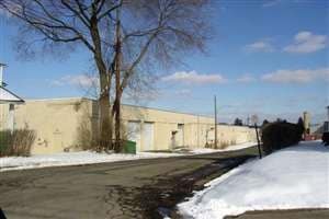
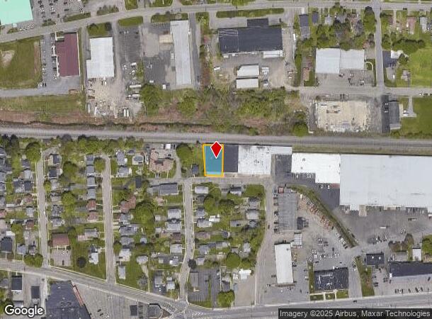
Property Record
105 Brink St, Endicott, NY 13760
NEARBY LISTINGS FOR SALE OR LEASE
Property Detail
105 Brink St
Binghamton, NY
COM 0030J7000K14X0000000
034689-141-020-0006-005-000-0000
Broome
Warehouse
New York
2025
5.000
2024
0.21 AC
013100
Broome County
12,875 SF
Syracuse
DEMOGRAPHICS near 105 Brink St
1 Mile
3 Mile
5 Mile
2024 Total Population
10,836
48,022
93,803
2029 Population
10,516
46,923
91,826
Pop Growth 2024-2029
(2.95%)
(2.29%)
(2.11%)
Average Age
41
42
41
2024 Total Households
4,918
20,496
37,387
HH Growth 2024-2029
(3.09%)
(2.49%)
(2.38%)
Median Household Inc
$54,304
$63,701
$58,634
Avg Household Size
2.20
2.20
2.20
2024 Avg HH Vehicles
1.00
2.00
2.00
Median Home Value
$125,178
$149,620
$144,610
Median Year Built
1951
1957
1956
Nearby Places
- Restaurants
- Banks
- Shops
- Fitness
- Groceries
PUBLIC TRANSPORTATION
AIRPORT
Ithaca Tompkins International
DRIVE
WALK
Distance
Ithaca Tompkins International
72 min
46.2 mi
SALE & LEASE HISTORY
LISTING DATE
SALE/LEASE

Sep 23, 2016
For Sale
Oct 11, 2017
For Sale
May 30, 2017
For Lease
Jun 16, 2017
For Sale
Nearby Properties
Address
Land Use
TOTAL SIZE
Lot Size
Zoning
Address
Land Use
TOTAL SIZE
Lot Size
Zoning
Address
Land Use
TOTAL SIZE
Lot Size
Zoning
203,306 SF
30.33 AC
C-2
Address
Land Use
TOTAL SIZE
Lot Size
Zoning
198,892 SF
40.31 AC
RR
Address
Land Use
TOTAL SIZE
Lot Size
Zoning
124,053 SF
7.63 AC
RC
Address
Land Use
TOTAL SIZE
Lot Size
Zoning
206,537 SF
15.02 AC
C-2
Address
Land Use
TOTAL SIZE
Lot Size
Zoning
117,267 SF
17.65 AC
C-2
Address
Land Use
TOTAL SIZE
Lot Size
Zoning
93,010 SF
12.32 AC
Address
Land Use
TOTAL SIZE
Lot Size
Zoning
126,000 SF
10.76 AC
C-2
Address
Land Use
TOTAL SIZE
Lot Size
Zoning
139,175 SF
13.43 AC
C-2
Address
Land Use
TOTAL SIZE
Lot Size
Zoning
135,382 SF
14.47 AC
Address
Land Use
TOTAL SIZE
Lot Size
Zoning
68,546 SF
28.40 AC
Address
Land Use
TOTAL SIZE
Lot Size
Zoning
87,842 SF
7.73 AC
C-2
Address
Land Use
TOTAL SIZE
Lot Size
Zoning
18,104 SF
9.94 AC
RC
Address
Land Use
TOTAL SIZE
Lot Size
Zoning
71,076 SF
12.22 AC
RR
Address
Land Use
TOTAL SIZE
Lot Size
Zoning
Address
Land Use
TOTAL SIZE
Lot Size
Zoning
24,600 SF
8.75 AC
RC
Address
Land Use
TOTAL SIZE
Lot Size
Zoning
33,600 SF
7.16 AC
RC
Address
Land Use
TOTAL SIZE
Lot Size
Zoning
58,604 SF
6.02 AC
I
Address
Land Use
TOTAL SIZE
Lot Size
Zoning
12,665 SF
2.65 AC
C-1
Address
Land Use
TOTAL SIZE
Lot Size
Zoning
74,394 SF
7.51 AC
C-2
Address
Land Use
TOTAL SIZE
Lot Size
Zoning
7,452 SF
3.47 AC
C-1
Address
Land Use
TOTAL SIZE
Lot Size
Zoning
8,840 SF
5.90 AC
RC
Address
Land Use
TOTAL SIZE
Lot Size
Zoning
954 SF
67.72 AC
CD
Address
Land Use
TOTAL SIZE
Lot Size
Zoning
29,750 SF
14.38 AC
RA-2
Address
Land Use
TOTAL SIZE
Lot Size
Zoning
56,411 SF
3.20 AC
C-1
Address
Land Use
TOTAL SIZE
Lot Size
Zoning
69,590 SF
8.51 AC
C-1
Address
Land Use
TOTAL SIZE
Lot Size
Zoning
58,480 SF
2.60 AC
C-2
Address
Land Use
TOTAL SIZE
Lot Size
Zoning
45,398 SF
1.29 AC
C-2
Address
Land Use
TOTAL SIZE
Lot Size
Zoning
15,624 SF
4.08 AC
RR
Address
Land Use
TOTAL SIZE
Lot Size
Zoning
31,973 SF
4.11 AC
C-2
The World's #1 Commercial Real Estate Marketplace
Connect with us
© 2025 CoStar Group
The information above has been obtained from sources believed reliable. While we do not doubt its accuracy we have not verified it and make no guarantee, warranty or representation about it. It is your responsibility to independently confirm its accuracy and completeness. Any projections, opinions, assumptions, or estimates used are for example only and do not represent the current or future performance of the property. The value of this transaction to you depends on tax and other factors which should be evaluated by your tax, financial, and legal advisors. You and your advisors should conduct a careful, independent investigation of the property to determine to your satisfaction the suitability of the property for your needs.