Property Record
105 Chapman Rd, Anderson, SC 29625


Save to a Folder
{{folder.Name}}
{{folder.ListingIds.length}} Properties
{{folder.ListingIds.length}} Property
Create a New Folder
Property Detail
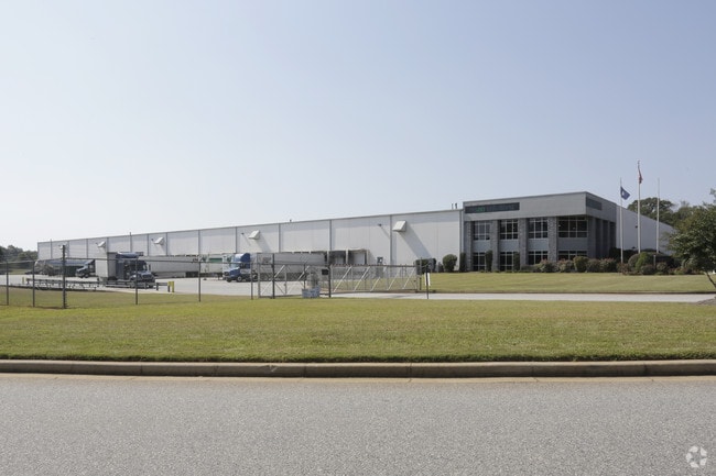
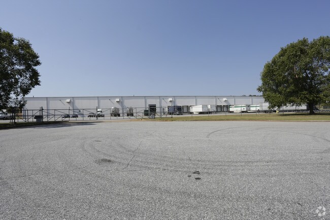
105 Chapman Rd
065-06-01-001
CP S 1806/8 F000 D000 PP S 1350/4 CHAPMAN RD 24.88 AC
Warehouse
Anderson
B and X Area of moderate flood hazard, usually the area between the limits of the 100-year and 500-year floods.
South Carolina
2025
24.88 AC
2025
Outlying Anderson Co
010602
Greenville/Spartanburg
125,000 SF
Greenville-Anderson-Greer, SC
NEARBY LISTINGS FOR SALE OR LEASE
DEMOGRAPHICS near 105 Chapman Rd
1 mile
3 mile
5 mile
2025 Total Population
481
8,426
31,663
2030 Population
492
8,880
33,259
Pop Growth 2025-2030
+ 2.29%
+ 5.39%
+ 5.04%
Average Age
44
44
42
2025 Total Households
194
3,547
13,465
HH Growth 2025-2030
+ 3.09%
+ 5.72%
+ 5.34%
Median Household Inc
$71,052
$72,746
$69,667
Avg Household Size
2.40
2.30
2.30
2025 Avg HH Vehicles
2.00
2.00
2.00
Median Home Value
$286,841
$273,712
$265,300
Median Year Built
1990
1989
1990
Nearby Places
Map Layers
Map Styles
 Street
 Aerial
Layers
 Traffic
 Biking
Places
Listings with unknown addresses are not visible on the map
- Restaurants
- Banks
- Shops
- Fitness
- Groceries
PUBLIC TRANSPORTATION
COMMUTER RAIL
Drive
Walk
Distance
16 min
9.7 mi
AIRPORT
Greenville Spartanburg International
Drive
Walk
Distance
Greenville Spartanburg International
52 min
41.1 mi
Nearby Properties
Address
Land Use
TOTAL SIZE
Lot Size
Zoning
Address
Land Use
TOTAL SIZE
Lot Size
Zoning
220.33 AC
Address
Land Use
TOTAL SIZE
Lot Size
Zoning
1,310 SF
31.53 AC
Address
Land Use
TOTAL SIZE
Lot Size
Zoning
36,891 SF
3.14 AC
Address
Land Use
TOTAL SIZE
Lot Size
Zoning
102,816 SF
28.36 AC
Address
Land Use
TOTAL SIZE
Lot Size
Zoning
68,593 SF
2.46 AC
Address
Land Use
TOTAL SIZE
Lot Size
Zoning
2,078 SF
44.20 AC
Address
Land Use
TOTAL SIZE
Lot Size
Zoning
Address
Land Use
TOTAL SIZE
Lot Size
Zoning
6,500 SF
7.41 AC
Address
Land Use
TOTAL SIZE
Lot Size
Zoning
41,054 SF
2.04 AC
Address
Land Use
TOTAL SIZE
Lot Size
Zoning
35,305 SF
1.93 AC
Address
Land Use
TOTAL SIZE
Lot Size
Zoning
44,089 SF
6.94 AC
Address
Land Use
TOTAL SIZE
Lot Size
Zoning
6,166 SF
1.92 AC
Address
Land Use
TOTAL SIZE
Lot Size
Zoning
22,545 SF
5.20 AC
Address
Land Use
TOTAL SIZE
Lot Size
Zoning
38.90 AC
Address
Land Use
TOTAL SIZE
Lot Size
Zoning
5,839 SF
6.03 AC
Address
Land Use
TOTAL SIZE
Lot Size
Zoning
121,275 SF
18.25 AC
Address
Land Use
TOTAL SIZE
Lot Size
Zoning
11,067 SF
3 AC
Address
Land Use
TOTAL SIZE
Lot Size
Zoning
1.68 AC
Address
Land Use
TOTAL SIZE
Lot Size
Zoning
13.14 AC
Address
Land Use
TOTAL SIZE
Lot Size
Zoning
3,960 SF
1.03 AC
Address
Land Use
TOTAL SIZE
Lot Size
Zoning
139.61 AC
Address
Land Use
TOTAL SIZE
Lot Size
Zoning
40,086 SF
1.42 AC
Address
Land Use
TOTAL SIZE
Lot Size
Zoning
38,551 SF
0.96 AC
Address
Land Use
TOTAL SIZE
Lot Size
Zoning
Address
Land Use
TOTAL SIZE
Lot Size
Zoning
Address
Land Use
TOTAL SIZE
Lot Size
Zoning
5,301 SF
1.90 AC
The World's #1 Commercial Real Estate Marketplace
Connect with us
© 2026 CoStar Group
The information above has been obtained from sources believed reliable. While we do not doubt its accuracy we have not verified it and make no guarantee, warranty or representation about it. It is your responsibility to independently confirm its accuracy and completeness. Any projections, opinions, assumptions, or estimates used are for example only and do not represent the current or future performance of the property. The value of this transaction to you depends on tax and other factors which should be evaluated by your tax, financial, and legal advisors. You and your advisors should conduct a careful, independent investigation of the property to determine to your satisfaction the suitability of the property for your needs.