Property Record
105 Coal St, Mc Donald, PA 15057


NEARBY LISTINGS FOR SALE OR LEASE
-
-
View all Mc Donald listings for sale on LoopNet.com
Property Detail
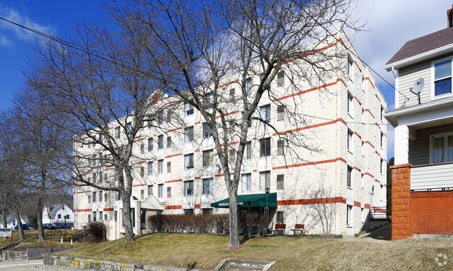
105 Coal St
Pittsburgh, PA
LOTS 25-29 3 STY BR BLDG
4700140001000200
Washington
Apartment
Pennsylvania
X
25
42125C0176E
0.86 AC
2025
Washington County
2025
Pittsburgh
715700
DEMOGRAPHICS near 105 Coal St
1 Mile
3 Mile
5 Mile
2024 Total Population
3,180
10,576
32,669
2029 Population
3,187
10,502
32,524
Pop Growth 2024-2029
+ 0.22%
(0.70%)
(0.44%)
Average Age
44
41
41
2024 Total Households
1,440
4,145
12,575
HH Growth 2024-2029
+ 0.28%
(0.60%)
(0.44%)
Median Household Inc
$63,170
$89,252
$95,777
Avg Household Size
2.20
2.50
2.50
2024 Avg HH Vehicles
2.00
2.00
2.00
Median Home Value
$158,290
$260,216
$264,861
Median Year Built
1947
1970
1980
Nearby Places
Map Layers
Map Styles
 Street
 Aerial
- Restaurants
- Banks
- Shops
- Fitness
- Groceries
PUBLIC TRANSPORTATION
AIRPORT
Pittsburgh International
DRIVE
WALK
Distance
Pittsburgh International
30 min
14.8 mi
Nearby Properties
Address
Land Use
TOTAL SIZE
Lot Size
Zoning
Address
Land Use
TOTAL SIZE
Lot Size
Zoning
2.08 AC
Address
Land Use
TOTAL SIZE
Lot Size
Zoning
7.44 AC
Address
Land Use
TOTAL SIZE
Lot Size
Zoning
Address
Land Use
TOTAL SIZE
Lot Size
Zoning
269.80 AC
Address
Land Use
TOTAL SIZE
Lot Size
Zoning
224.31 AC
Address
Land Use
TOTAL SIZE
Lot Size
Zoning
10,212 SF
4.39 AC
Address
Land Use
TOTAL SIZE
Lot Size
Zoning
3.57 AC
Address
Land Use
TOTAL SIZE
Lot Size
Zoning
0.31 AC
Address
Land Use
TOTAL SIZE
Lot Size
Zoning
27,340 SF
5.50 AC
Address
Land Use
TOTAL SIZE
Lot Size
Zoning
11.49 AC
Address
Land Use
TOTAL SIZE
Lot Size
Zoning
1.88 AC
Address
Land Use
TOTAL SIZE
Lot Size
Zoning
0.25 AC
Address
Land Use
TOTAL SIZE
Lot Size
Zoning
1.76 AC
Address
Land Use
TOTAL SIZE
Lot Size
Zoning
0.30 AC
Address
Land Use
TOTAL SIZE
Lot Size
Zoning
4,498 SF
73.26 AC
Address
Land Use
TOTAL SIZE
Lot Size
Zoning
2,278 SF
42 AC
Address
Land Use
TOTAL SIZE
Lot Size
Zoning
5,256 SF
14.29 AC
Address
Land Use
TOTAL SIZE
Lot Size
Zoning
1,764 SF
0.32 AC
Address
Land Use
TOTAL SIZE
Lot Size
Zoning
1,844 SF
58.70 AC
Address
Land Use
TOTAL SIZE
Lot Size
Zoning
0.34 AC
Address
Land Use
TOTAL SIZE
Lot Size
Zoning
0.25 AC
Address
Land Use
TOTAL SIZE
Lot Size
Zoning
4,684 SF
29.10 AC
Address
Land Use
TOTAL SIZE
Lot Size
Zoning
238.36 AC
Address
Land Use
TOTAL SIZE
Lot Size
Zoning
3,533 SF
57.44 AC
Address
Land Use
TOTAL SIZE
Lot Size
Zoning
0.32 AC
Address
Land Use
TOTAL SIZE
Lot Size
Zoning
3.75 AC
Address
Land Use
TOTAL SIZE
Lot Size
Zoning
Address
Land Use
TOTAL SIZE
Lot Size
Zoning
3,778 SF
8 AC
The World's #1 Commercial Real Estate Marketplace
Connect with us
© 2026 CoStar Group
The information above has been obtained from sources believed reliable. While we do not doubt its accuracy we have not verified it and make no guarantee, warranty or representation about it. It is your responsibility to independently confirm its accuracy and completeness. Any projections, opinions, assumptions, or estimates used are for example only and do not represent the current or future performance of the property. The value of this transaction to you depends on tax and other factors which should be evaluated by your tax, financial, and legal advisors. You and your advisors should conduct a careful, independent investigation of the property to determine to your satisfaction the suitability of the property for your needs.