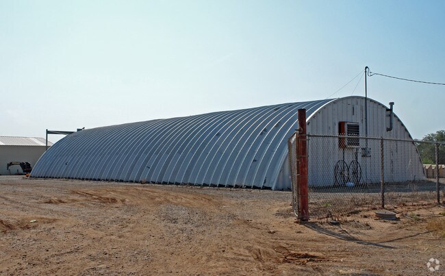
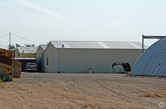
Property Record
105 E 32Nd St, Plainview, TX 79072
Property Detail
105 E 32Nd St
24234
MARTIN-HARLAN PLV BLK 11 NW/4 EX SOLD PTS 3.878 AC
Commercialnec
HALE
B and X Area of moderate flood hazard, usually the area between the limits of the 100-year and 500-year floods.
Texas
2025
3.88 AC
2025
Panhandle Area
950500
Other Market Areas
20,364 SF
Plainview, TX
NEARBY LISTINGS FOR SALE OR LEASE
DEMOGRAPHICS near 105 E 32Nd St
1 mile
3 mile
5 mile
2025 Total Population
3,589
19,856
23,104
2030 Population
3,593
19,615
22,789
Pop Growth 2025-2030
+ 0.11%
(1.21%)
(1.36%)
Average Age
36
37
38
2025 Total Households
1,247
6,926
8,044
HH Growth 2025-2030
+ 0.32%
(1.24%)
(1.47%)
Median Household Inc
$44,331
$46,386
$48,829
Avg Household Size
2.80
2.70
2.60
2025 Avg HH Vehicles
2.00
2.00
2.00
Median Home Value
$55,251
$96,179
$102,941
Median Year Built
1968
1966
1966
Nearby Places
Map Layers
Map Styles
 Street
 Aerial
Transit
 Traffic
 Biking
Places
Listings with unknown addresses are not visible on the map
- Restaurants
- Banks
- Shops
- Fitness
- Groceries
Nearby Properties
Address
Land Use
TOTAL SIZE
Lot Size
Zoning
Address
Land Use
TOTAL SIZE
Lot Size
Zoning
290,304 SF
98.06 AC
Address
Land Use
TOTAL SIZE
Lot Size
Zoning
169,517 SF
2.76 AC
Address
Land Use
TOTAL SIZE
Lot Size
Zoning
75,000 SF
6.67 AC
Address
Land Use
TOTAL SIZE
Lot Size
Zoning
142,098 SF
28.62 AC
Address
Land Use
TOTAL SIZE
Lot Size
Zoning
7,532 SF
10.83 AC
Address
Land Use
TOTAL SIZE
Lot Size
Zoning
149,000 SF
27.30 AC
Address
Land Use
TOTAL SIZE
Lot Size
Zoning
180,520 SF
26.52 AC
Address
Land Use
TOTAL SIZE
Lot Size
Zoning
105,109 SF
11.19 AC
Address
Land Use
TOTAL SIZE
Lot Size
Zoning
177,376 SF
15.73 AC
Address
Land Use
TOTAL SIZE
Lot Size
Zoning
118,100 SF
2.45 AC
Address
Land Use
TOTAL SIZE
Lot Size
Zoning
154,595 SF
14.14 AC
Address
Land Use
TOTAL SIZE
Lot Size
Zoning
93,784 SF
8.15 AC
Address
Land Use
TOTAL SIZE
Lot Size
Zoning
60,973 SF
3.86 AC
Address
Land Use
TOTAL SIZE
Lot Size
Zoning
80,443 SF
2.57 AC
Address
Land Use
TOTAL SIZE
Lot Size
Zoning
83,501 SF
1.96 AC
Address
Land Use
TOTAL SIZE
Lot Size
Zoning
30,978 SF
3.89 AC
Address
Land Use
TOTAL SIZE
Lot Size
Zoning
79,406 SF
4.26 AC
Address
Land Use
TOTAL SIZE
Lot Size
Zoning
117,704 SF
6.68 AC
Address
Land Use
TOTAL SIZE
Lot Size
Zoning
Address
Land Use
TOTAL SIZE
Lot Size
Zoning
40,458 SF
1.90 AC
Address
Land Use
TOTAL SIZE
Lot Size
Zoning
172,558 SF
4.46 AC
Address
Land Use
TOTAL SIZE
Lot Size
Zoning
87,986 SF
6.50 AC
Address
Land Use
TOTAL SIZE
Lot Size
Zoning
Address
Land Use
TOTAL SIZE
Lot Size
Zoning
341,021 SF
9.07 AC
Address
Land Use
TOTAL SIZE
Lot Size
Zoning
32,253 SF
2.07 AC
Address
Land Use
TOTAL SIZE
Lot Size
Zoning
46,861 SF
12.60 AC
Address
Land Use
TOTAL SIZE
Lot Size
Zoning
265,444 SF
5.36 AC
Address
Land Use
TOTAL SIZE
Lot Size
Zoning
100,000 SF
3.03 AC
Address
Land Use
TOTAL SIZE
Lot Size
Zoning
108,226 SF
11.48 AC
Address
Land Use
TOTAL SIZE
Lot Size
Zoning
19,556 SF
0.80 AC
The World's #1 Commercial Real Estate Marketplace
Connect with us
© 2026 CoStar Group
The information above has been obtained from sources believed reliable. While we do not doubt its accuracy we have not verified it and make no guarantee, warranty or representation about it. It is your responsibility to independently confirm its accuracy and completeness. Any projections, opinions, assumptions, or estimates used are for example only and do not represent the current or future performance of the property. The value of this transaction to you depends on tax and other factors which should be evaluated by your tax, financial, and legal advisors. You and your advisors should conduct a careful, independent investigation of the property to determine to your satisfaction the suitability of the property for your needs.