Property Record
105 E La Platte Rd, , NE
Property Detail
105 E La Platte Rd
Omaha, NE-IA
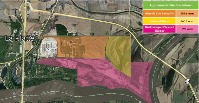
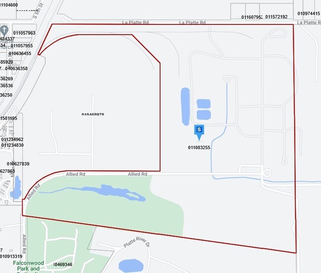
TAX LOT 9 24-13-13 (1.37 AC)
011083263
SARPY
Agriculturalland
Nebraska
IGM
9
AE The base floodplain where base flood elevations are provided. AE Zones are now used on new format FIRMs instead of A1-A30 Zones.
4.75 AC
2024
Southeast Omaha
2025
Omaha/Council Bluffs
010305
NEARBY LISTINGS FOR SALE OR LEASE
DEMOGRAPHICS near 105 E La Platte Rd
1 mile
3 mile
5 mile
2025 Total Population
129
5,714
40,238
2030 Population
138
6,119
42,473
Pop Growth 2025-2030
+ 6.98%
+ 7.09%
+ 5.55%
Average Age
37
39
37
2025 Total Households
52
2,170
15,151
HH Growth 2025-2030
+ 7.69%
+ 7.28%
+ 5.72%
Median Household Inc
$94,642
$116,845
$87,975
Avg Household Size
2.40
2.60
2.60
2025 Avg HH Vehicles
2.00
2.00
2.00
Median Home Value
$290,624
$352,240
$272,284
Median Year Built
1994
2003
1987
Nearby Places
Map Layers
Map Styles
 Street
 Aerial
Transit
 Traffic
 Biking
Places
Listings with unknown addresses are not visible on the map
- Restaurants
- Banks
- Shops
- Fitness
- Groceries
PUBLIC TRANSPORTATION
AIRPORT
Eppley Airfield
Drive
Walk
Distance
Eppley Airfield
35 min
22.4 mi
Freight Ports
Tulsa Port Of Catoosa
Drive
Walk
Distance
Tulsa Port Of Catoosa
446 min
404.5 mi
SALE & LEASE HISTORY
LISTING DATE
SALE/LEASE

May 16, 2017
For Sale
Nearby Properties
Address
Land Use
TOTAL SIZE
Lot Size
Zoning
Address
Land Use
TOTAL SIZE
Lot Size
Zoning
10,800 SF
12.03 AC
Address
Land Use
TOTAL SIZE
Lot Size
Zoning
2,440 SF
18.88 AC
RG28
Address
Land Use
TOTAL SIZE
Lot Size
Zoning
121,660 SF
9.23 AC
RG28
Address
Land Use
TOTAL SIZE
Lot Size
Zoning
141,620 SF
84.13 AC
ILM
Address
Land Use
TOTAL SIZE
Lot Size
Zoning
Address
Land Use
TOTAL SIZE
Lot Size
Zoning
101,606 SF
5.01 AC
RG20
Address
Land Use
TOTAL SIZE
Lot Size
Zoning
5,400 SF
0.80 AC
MH
Address
Land Use
TOTAL SIZE
Lot Size
Zoning
43.33 AC
RD50
Address
Land Use
TOTAL SIZE
Lot Size
Zoning
12,000 SF
2.95 AC
03-COMMERC
Address
Land Use
TOTAL SIZE
Lot Size
Zoning
1,152 SF
319.20 AC
AG
Address
Land Use
TOTAL SIZE
Lot Size
Zoning
10,000 SF
34.82 AC
04-INDUSTR
Address
Land Use
TOTAL SIZE
Lot Size
Zoning
5,001 SF
4.91 AC
Address
Land Use
TOTAL SIZE
Lot Size
Zoning
304.68 AC
AG
Address
Land Use
TOTAL SIZE
Lot Size
Zoning
292.40 AC
AG
Address
Land Use
TOTAL SIZE
Lot Size
Zoning
14,758 SF
43.38 AC
AG
Address
Land Use
TOTAL SIZE
Lot Size
Zoning
48,677 SF
0.74 AC
IL
Address
Land Use
TOTAL SIZE
Lot Size
Zoning
8,225 SF
11.99 AC
IL
Address
Land Use
TOTAL SIZE
Lot Size
Zoning
5,092 SF
1.78 AC
BNH
Address
Land Use
TOTAL SIZE
Lot Size
Zoning
8,000 SF
12.95 AC
03-COMMERC
Address
Land Use
TOTAL SIZE
Lot Size
Zoning
24,000 SF
2.70 AC
IL
Address
Land Use
TOTAL SIZE
Lot Size
Zoning
864 SF
74.43 AC
RD50
Address
Land Use
TOTAL SIZE
Lot Size
Zoning
14,760 SF
4.48 AC
BHS
Address
Land Use
TOTAL SIZE
Lot Size
Zoning
28.05 AC
03-COMMERC
Address
Land Use
TOTAL SIZE
Lot Size
Zoning
5,280 SF
113.22 AC
AG
Address
Land Use
TOTAL SIZE
Lot Size
Zoning
2,709 SF
138.39 AC
AG
Address
Land Use
TOTAL SIZE
Lot Size
Zoning
14.76 AC
RS72
Address
Land Use
TOTAL SIZE
Lot Size
Zoning
7,169 SF
9.77 AC
AG
The World's #1 Commercial Real Estate Marketplace
Connect with us
© 2026 CoStar Group
The information above has been obtained from sources believed reliable. While we do not doubt its accuracy we have not verified it and make no guarantee, warranty or representation about it. It is your responsibility to independently confirm its accuracy and completeness. Any projections, opinions, assumptions, or estimates used are for example only and do not represent the current or future performance of the property. The value of this transaction to you depends on tax and other factors which should be evaluated by your tax, financial, and legal advisors. You and your advisors should conduct a careful, independent investigation of the property to determine to your satisfaction the suitability of the property for your needs.