Property Record
105 Emily Dr, Moore, SC 29369
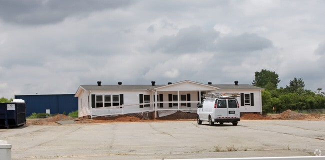
Property Detail
105 Emily Dr
Spartanburg, SC
W SIDE ASHEVILLE HWY & N SIDE ALICE STREET PB 131-304 PB 167-625
5-38-00-013.00
SPARTANBURG
Residentialacreage
South Carolina
B and X Area of moderate flood hazard, usually the area between the limits of the 100-year and 500-year floods.
1.02 AC
2024
North Side/Rt 9 Corr
2025
Greenville/Spartanburg
021600
NEARBY LISTINGS FOR SALE OR LEASE
DEMOGRAPHICS near 105 Emily Dr
1 mile
3 mile
5 mile
2025 Total Population
4,425
46,726
112,787
2030 Population
4,907
52,192
125,873
Pop Growth 2025-2030
+ 10.89%
+ 11.70%
+ 11.60%
Average Age
37
36
38
2025 Total Households
1,501
17,358
44,314
HH Growth 2025-2030
+ 11.26%
+ 12.13%
+ 11.81%
Median Household Inc
$34,504
$45,945
$54,578
Avg Household Size
2.50
2.40
2.40
2025 Avg HH Vehicles
2.00
2.00
2.00
Median Home Value
$126,229
$162,640
$211,350
Median Year Built
1974
1980
1983
Nearby Places
Map Layers
Map Styles
 Street
 Aerial
Layers
 Traffic
 Biking
Places
Listings with unknown addresses are not visible on the map
- Restaurants
- Banks
- Shops
- Fitness
- Groceries
PUBLIC TRANSPORTATION
AIRPORT
Greenville Spartanburg International
Drive
Walk
Distance
Greenville Spartanburg International
23 min
13.3 mi
Freight Ports
North Charleston Terminal
Drive
Walk
Distance
North Charleston Terminal
216 min
192.1 mi
Nearby Properties
Address
Land Use
TOTAL SIZE
Lot Size
Zoning
Address
Land Use
TOTAL SIZE
Lot Size
Zoning
210.98 AC
Address
Land Use
TOTAL SIZE
Lot Size
Zoning
14,168 SF
8.33 AC
Address
Land Use
TOTAL SIZE
Lot Size
Zoning
27,288 SF
19.85 AC
Address
Land Use
TOTAL SIZE
Lot Size
Zoning
2,417 SF
21.12 AC
Address
Land Use
TOTAL SIZE
Lot Size
Zoning
15,300 SF
13.48 AC
Address
Land Use
TOTAL SIZE
Lot Size
Zoning
38,313 SF
15.53 AC
Address
Land Use
TOTAL SIZE
Lot Size
Zoning
10,126 SF
11.86 AC
Address
Land Use
TOTAL SIZE
Lot Size
Zoning
1,312 SF
415.98 AC
Address
Land Use
TOTAL SIZE
Lot Size
Zoning
6,290 SF
Address
Land Use
TOTAL SIZE
Lot Size
Zoning
393,732 SF
11.88 AC
Address
Land Use
TOTAL SIZE
Lot Size
Zoning
5,860 SF
0.90 AC
Address
Land Use
TOTAL SIZE
Lot Size
Zoning
6,086 SF
1.20 AC
Address
Land Use
TOTAL SIZE
Lot Size
Zoning
170,279 SF
17.56 AC
Address
Land Use
TOTAL SIZE
Lot Size
Zoning
4,028 SF
0.25 AC
Address
Land Use
TOTAL SIZE
Lot Size
Zoning
51,914 SF
13.69 AC
Address
Land Use
TOTAL SIZE
Lot Size
Zoning
6,121 SF
2.78 AC
Address
Land Use
TOTAL SIZE
Lot Size
Zoning
6,609 SF
2.01 AC
Address
Land Use
TOTAL SIZE
Lot Size
Zoning
5,697 SF
23.10 AC
Address
Land Use
TOTAL SIZE
Lot Size
Zoning
4,026 SF
0.20 AC
Address
Land Use
TOTAL SIZE
Lot Size
Zoning
3,308 SF
0.21 AC
Address
Land Use
TOTAL SIZE
Lot Size
Zoning
1,861 SF
155.78 AC
Address
Land Use
TOTAL SIZE
Lot Size
Zoning
5,296 SF
0.61 AC
Address
Land Use
TOTAL SIZE
Lot Size
Zoning
3,851 SF
0.60 AC
Address
Land Use
TOTAL SIZE
Lot Size
Zoning
2,460 SF
0.17 AC
Address
Land Use
TOTAL SIZE
Lot Size
Zoning
5,273 SF
0.85 AC
Address
Land Use
TOTAL SIZE
Lot Size
Zoning
3,251 SF
0.17 AC
Address
Land Use
TOTAL SIZE
Lot Size
Zoning
3,896 SF
0.53 AC
Address
Land Use
TOTAL SIZE
Lot Size
Zoning
9,594 SF
Address
Land Use
TOTAL SIZE
Lot Size
Zoning
4,004 SF
0.33 AC
Address
Land Use
TOTAL SIZE
Lot Size
Zoning
12.76 AC
The World's #1 Commercial Real Estate Marketplace
Connect with us
© 2026 CoStar Group
The information above has been obtained from sources believed reliable. While we do not doubt its accuracy we have not verified it and make no guarantee, warranty or representation about it. It is your responsibility to independently confirm its accuracy and completeness. Any projections, opinions, assumptions, or estimates used are for example only and do not represent the current or future performance of the property. The value of this transaction to you depends on tax and other factors which should be evaluated by your tax, financial, and legal advisors. You and your advisors should conduct a careful, independent investigation of the property to determine to your satisfaction the suitability of the property for your needs.